Today all land users should know how to survey a plot of land. This issue is especially acute for those who are faced with certain problems associated with various inaccuracies of the legal side of the issue. The answer to the question posed will also be of interest to those who decide to buy a plot of land (with or without buildings) and not inadvertently end up breaking the law.
To correctly determine the boundaries of a land plot, complex procedures must be followed, so it is absolutely not enough to drive stakes or install a permanent fence yourself. It is also noteworthy that in the latter case there is a high probability of all sorts of disputes arising with neighbors or even representatives of the executive committee, which often acts as the sole legal holder of the territory.
Before starting the land surveying process itself, applicants should know and understand for themselves not only where they can demarcate the site and where to go on this issue, but also resolve any issues that arise related to solving problems. Most often they relate to the order in which the work will be carried out and by what structures.
Also, those who are interested in establishing boundaries are always interested in answers to questions related not only to costs and the actual cost of work and their order. It is important for customers to know the length of time it will take to legally complete the procedure. All this is described in detail in the article. Separately, it is worth noting the fact that the priority and order of the applicant’s actions do not differ in most countries of the post-Soviet space, so the information will be useful to readers from the CIS.
Cost of land surveying
The need to carry out legal procedures confronts plot owners with the need to register their plot. There is no point in carrying out measuring activities on your own. Only licensed professionals should be involved in such activities.
Important!
Measuring activities carried out by a company without a license, or by the owner personally, will not have legal force. Rosreestr, court and other authorities accept the results of land surveying of licensed organizations.
There are several federal and regional programs under which border marking can be done at the expense of the state. In other cases, you have to order the service from commercial companies. For plot owners, a logical question arises: how much does land surveying cost in 2020? Let's look at prices in Moscow and the region.
Be responsible when choosing a company or engineer. The specialist must belong to an SRO and have a qualification certificate. Low cost of services is not the main selection criterion. You need to pay attention to the quality of the work performed; it can be determined by the number of unfinished tasks and errors.
Approximate prices on the market
Cadastral specialists can set prices for services based on different criteria. But it is not permissible to exceed the maximum tariffs stipulated by law. Unauthorized price increases will result in a fine. But you must also take into account that land surveying costs may include payment for additional services.
It is worth talking separately about the lands allocated for agriculture. Their surveying requires less money than plots in a populated area. Let's consider approximate prices taking into account the area of land.
| Average cost of agricultural land surveying | |
| Allotment size, in hectares | Amount in rubles per 1 ha |
| Less than 10 | 3000, but not less than 13,000 for the entire work |
| Up to 30 | 2500 |
| No more than 50 | 2000 |
| From 50 | 1500 |
When surveying agricultural plots, you will have to pay 300 rubles for 1 point. The category of additional costs is the registration of a cadastral passport, which is about 5,000 rubles.
| Costs of land surveying in a populated area | |
| Evaluation criteria based on the number of points | Payment in rubles |
| Up to 5 | 1000 for 1 point |
| 5-15 | 1500 for work within normal limits and 700 for each subsequent point |
| Over 15 | 4500 per event + 400 per 1 point above the standard |
Cost of work
The cost of land surveying work not only varies across federal districts, but may also vary depending on various components. The price of the service depends entirely on many factors, the main ones being:
- accessibility of the area for taking measurements using standard methods and simple measuring instruments;
- use of instruments and software to establish plot boundaries;
- weather conditions and regional terrain features;
- the length of the sides of the site and the number of points whose coordinates need to be calculated;
- technological complexity of the work for the contractor;
- price per hour of work (hourly rate) of the land surveyor (set by the enterprise independently, since most organizations are self-supporting groups).
Also, the cost of work to document the boundaries of a plot of land includes the so-called “urgency”.
The State Certificate price for land is set by the self-government body on whose territory the land plot is located, and also includes mandatory duties and fees. On the territory of some federal districts there is a special procedure and limited rates of fees for work to establish rights to plots of land used:
- associations of citizens (gardening societies for growing fruit and berry crops) and unorganized individuals for growing vegetables and fruits;
- for private construction, landscaping and subsequent operation of houses and ancillary buildings;
- for running a household that does not involve commercial use of land (including leasing);
- garage cooperatives.
This category also includes plots allocated for separate buildings for storing personal vehicles.
An applicant who applies to government agencies to establish property rights to a newly allocated plot pays a fee, the amount of which is established by current legislation, a protocol of a community meeting or any other document of federal, regional or city significance. It should be noted that the amount of the state duty, the cost of cartographic or geodetic work, as well as other fees depends on many factors, including:
- economically significant indicators (profitability, profit, reimbursement of taxes and fees, business expenses of the contractor, be it the cost of renting premises, depreciation, etc.), included in the price list for the provision of various types of services to land users;
- the minimum hourly rate of workers involved in the work;
- subsistence minimum valid at the time of application;
- the cost of information services from organizations where you can order the land demarcation procedure.
You can reduce the cost of dividing land plots by applying for the provision of geodetic services to state-owned institutions. In such institutions, the fee is minimal and does not contain hidden fees. But in state geodetic services or departments there is usually a waiting list for work, so along with saving money, the applicant usually loses a lot of time, and some documents have to be ordered several times, because visas of notaries and government agencies have an “expiration date.”
It is not possible to carry out surveying of a land plot completely free of charge, although some categories of citizens (the list of benefits approved at the legislative level of the state, federal district or other territorial unit) may be exempt from paying all or part of the fee charged for the services of state enterprises involved in the process of issuing documentary evidence of the boundaries of the site.
In some cases, certain groups of applicants may not be able to pay out-of-pocket costs for special security forms or court-related procedures. Also, certain categories of citizens can find out for free or on preferential terms whether land surveying has been done previously, and also receive a certificate about this.
That is why it is not possible to give unambiguous answers to questions about how much it costs to survey a land plot, as well as what the cost of services is established in 2020. The only thing that can be said on this issue is that the cost of issuing documents for a previously unregistered site will be higher than the customer’s costs incurred in restoring or determining the boundaries of a previously documented site. And first of all, this is due to the procedure for assigning a land use class and checking documents related to obtaining official information that the site is not:
- located in protected, recreational or other environmental areas;
- belongs to no one else, and third parties have no right to dispose of it;
- is in collateral.
Read also: How to expel a person from an apartment without his consent?
The price of the work will vary due to the cost of the resource itself. That is why the cost of registering and measuring a plot in the Moscow or Leningrad region will be greater than the costs incurred by the applicant for registering rights and demarcating a plot in the Vladimir or, for example, Chelyabinsk region or Petrozavodsk. Also, a frequent criterion for the price of land surveying is the distance of the latter from the city, regional center or capital.
Stages of the procedure
The procedure for performing land surveying depends on what service the client orders. Let's consider the standard stages of interaction:
- Filing an application.
- Drawing up an estimate.
- Drawing up a cooperation agreement.
- Prepayment.
- Carrying out the entire range of work.
- Coordination and registration.
- Full repayment of the cost of services.
How to implement the procedure
Stage one - ordering a service
You should contact the Cadastral Bureau to clarify the terms of cooperation. You can call a commercial company directly to determine the interaction scheme and the approximate amount of expenses. At this stage, the client should have the following documents in his hands:
- Passport.
- Extract from the Unified State Register of Real Estate.
- Power of attorney (if you entrust the execution to a third party).
Stage two - notifying neighbors
The implementation of this stage takes place only if there are intervening plots. In this case, you need to notify interested parties a month before the start of work. There are several ways to do this:
- Written notification against signature (in person).
- Sending a registered letter. It is imperative to keep the delivery receipt with the recipient's signature.
- Read receipt email.
- Publication in a local print publication. This option is justified if the neighbors refuse to sign the notice or the applicant does not have contacts to send a letter.
This third one is preparation.
The participation of both performers and customers is required. The task of the first party is to study the type of terrain and analyze the proposed documents. At this time, the customer must prepare the area for exploration. It is necessary to free up access to the borders and clear the territory to facilitate the installation and use of equipment.
Stage four - geodetic operations
It brings together a whole range of events. Determine the actual configuration and area of the territory. This is a survey of the geodetic network, surveying of actual contours, instrumental work, study of characteristic points, and recording of coordinates. After processing the information, an act is drawn up, which is signed by all participants:
The procedure for clarifying the boundaries of land plots
Like most cadastral works, the order is as follows: preparation, field work, desk work/issuance of a finished document. Now more details.
1. First of all, you need to collect all the available documents (about them above⇑) for the site and formulate a task with which you will go to the geodetic company.
2. Next, contact our company and draw up an agreement for the provision of cadastral services. Also, the so-called “public contract” is often practiced with private individuals. That is, you simply pay a receipt () for the agreed amount indicating the type of work, and after the money arrives in our account, we complete the work within the stipulated period. Do not be afraid to resort to this payment method - this is an official confirmation of our cooperation.
3. Before our employee arrives at your site, you must notify your neighbors about the time of work if there are disagreements regarding adjacent boundaries. Many controversial issues can be resolved at the field stage of work. Neighbors should be notified at least 7 days before the survey.
4. On the appointed day, our cadastral engineers arrive and take measurements of the actual boundaries of the land plot. More details in the article “Geodetic field work during land surveying”.
During boundary measurements, cadastral engineers will ask adjacent land users present if they agree with the boundaries.
5. After carrying out field work, we begin to draw up a boundary plan and draw up an approval act. If adjacent land users have already undergone cadastral registration, then an agreement is not signed with them. The remaining owners will have to sign.
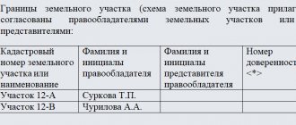
The approval document must be signed by the following persons:
• the owner of the plot or an authorized representative;
• adjacent neighbors, if they do not “stand” on the cadastre;
• cadastral engineer who carried out the work;
• a representative of the administration who certifies the boundaries of municipal or state lands.
6. When the approval act is signed, it is attached to the boundary plan and handed over to the Customer or handed over to the cadastral chamber by a representative of our company. Since an electronic form of the document is provided, it is signed with the digital seal of a cadastral engineer and sent using special programs to the Cadastral Chamber. Or the Customer submits an application and a recorded disk with an electronic interplane independently to the Rosreestr authority.
7. After checking the submitted documents, the Cadastral Chamber issues a cadastral passport/cadastral extract for the land plot (or a resolution to refuse/suspension of the cadastral registration procedure). In the second case, you need to contact us again with a resolution; we will sort it out.
If you have received a cadastral passport/extract, submit an application to the Registration Chamber, where, after reviewing your documents, you will be issued a new certificate for the updated land plot.
What does the cost consist of?
To determine how much land surveying costs, you need to track a number of circumstances. The need to provide additional services is taken into account. The more actions an engineer must perform, the higher the final cost will be.
List of mandatory procedures:
- Collection and preparation of information on the object.
- Geodetic operations for exploring the earth.
- Refinement of contours and their registration.
- Drawing up a detailed plan.
- Formation of a survey file, its submission to the cadastral chamber.
- Issuance of a cadastral passport.
At the stage of implementation of geodetic research activities, the presence of the owner himself, as well as neighbors of adjacent plots, is desirable. Such interaction allows us to resolve all controversial issues on the spot. All participants must sign a certificate of completion of work. If there are controversial issues, the dissatisfied party can express written disagreement, which is attached to the boundary file.
Important!
Private companies, when determining the exact boundaries and size of the plot, often charge an additional fee for transport support services. The list and payment for them is formed taking into account the company’s policy. On average, you will have to add 200-300 rubles.
Types of additional services:
- fare;
- payment for services of attracted specialists;
- combining several plots into one;
- delimitation of land into shares;
- urgent implementation;
- solving complex situations, one of which is surveying areas with heterogeneous terrain or large areas;
- registration without primary documents.
For reference!
If you involve a lawyer in the registration process, you will have to pay an additional 4,000 rubles or more, depending on the type of services provided. For division you will have to pay about 12,000; when merging, you need to spend from 2,000 rubles for each plot.
What does a boundary plan look like to clarify boundaries?
As we have said many times, boundary plans are like brothers. And besides the name on the title page, an inexperienced reader will not be able to understand the difference between them. There is no point in dwelling in detail on all sections of the boundary plan. These signs and diagrams will not tell the owner of the site anything useful. The cadastral engineer must ensure that the entire document is filled out correctly. It is perhaps worth paying attention to the “Conclusion of the cadastral engineer” and the “Boundary approval act”.
In the first mentioned section, all the features of the area being specified (if any), as well as the difficulties and conflict situations that arose as a result of the work, are indicated in coherent text. That is, if it is impossible to clarify the boundary due to intersection with other land plots or if representatives of neighboring plots refuse to coordinate the boundaries, all this will be indicated in the conclusion.
In the second section (if necessary), you will need to coordinate the location of the boundaries of the land plot with neighbors who have not yet carried out land surveying. The main thing here is not to make mistakes and carefully check all the data that is entered there. Incorrect completion of the “Act of Approval” often leads to a refusal to make changes to the land plot in cadastral registration.
To understand how the interplane should look, you can refer to the slider on the left. There is an example for clarifying boundaries.
It is worth noting that the paper version of the boundary plans, whether for clarification, or any other, is prepared exclusively for the Customer and then at his request. At the moment, all interplans are prepared electronically in XML format with attachments in PDF format. And it is in electronic form that they are submitted to the cadastral chamber along with the application.
Review of offers on the turnkey surveying market
Turnkey surveying is a full range of actions of the company, starting from collecting the document and ending with registering the object in Rosreestr. By ordering the service, the applicant deprives himself of the difficulties associated with registration. All activities, including notification of neighbors, are taken over by the service company.
For reference!
The minimum cost of “turnkey surveying” in Moscow is 15,000 rubles and is completed on average in 2-3 weeks.
Activities that include “turnkey surveying”:
- Legal analysis of the submitted land documentation.
- Departure of specialists with expensive equipment necessary to carry out complex survey operations.
- Notifying neighbors.
- Carrying out measurements on adjacent plots.
- Registration of a cadastral passport.
- Approval of the boundary plan.
- Registration of the property with the Cadastral Chamber.
- State registration of property rights.
- Support of controversial cases.
- Correction of errors, elimination of inaccuracies, if there are comments from the registration authority.
Important!
Often, the cost of a comprehensive service is completely justified, as it saves the client from the need to order support specialists. For example, “turnkey surveying” will allow controversial issues to be resolved by the service company’s lawyers. This saves the cost of paying for outside legal services.
Before ordering land surveying, look at the price lists of popular companies where you can compare prices. The data is presented in tabular form.
| Company | Minimum price for the service (in rubles) |
| BTI LLC | 12 000 |
| Grand Cadastre | 35 000 |
| Geo-Time | 10 000 |
| Petersburg geodesy | 15 000 |
| Geoleader | 10 000 |
| North-West Service Center | Negotiable amount, no minimum threshold |
| Geosector | 15 000 |
Cost of land surveying services (in rubles) in Moscow and the Moscow region when merging, dividing and changing the scheme without a surveyor visiting the site:
- Up to 1500 sq. m. sq. – from 15,000;
- 1501 – 2000 sq. m. – from 16,000;
- 2001-3000 squares – from 17,000;
- 3001-5000 sq. m. – 20,000.
Land surveying to clarify boundaries in case of redistribution, division and unification will cost (calculated in rubles):
- up to 1500 sq. m. – 25,000;
- from 1501 to 2000 square meters – 27,000;
- 2001-3000 sq. m. – 30000;
- 3001-5000 squares – 32,000.
Regardless of the type of survey, there will be additional costs. Upon receipt of the boundary plan and the formation of a new extract from the Unified State Register, you will have to pay about 3,000 more rubles.
For reference!
If in the Moscow and Leningrad region prices start from 10,000-15,000 rubles, then in other areas there are more loyal prices. In Krasnodar they start from 7000, in Krasnoyarsk from 2000-3000, and in Novosibirsk from 3000-5000 rubles.
Free survey
There are several programs that allow the procedure to be carried out at state expense. Let's look at them briefly. More detailed information is presented in the article about free land surveying in 2020.
Cases in which land surveying will be carried out free of charge:
- Dacha amnesty. The state has provided the opportunity to register allotments free of charge until January 1, 2021.
- Purchase, rental of an object at auction.
- Quarterly survey. For example, a gardening association decides to register the entire community. Owners will receive a free service at the expense of the municipality.
- State projects aimed at implementing the target program for the development of a unified cadastre system. In 2020, residents of Crimea and Mordovia, Kamchatka and Yakutia can become participants in the project.
Conditions for the implementation of free surveying for a special project:
- registered the land before 1998, but did not have time to register it in the Unified State Register of Real Estate;
- encountered a cadastral error during registration;
- The information was entered into Rosreestr, but the land cadastral registration was not completed.
The article is over. Do you have any questions? FREE legal consultation
☎ 8
hotline for Russian regions
With the introduction of the “dacha amnesty” law, the process of setting the boundaries of a land plot has been significantly simplified, and land surveying is no longer required. But this opens the field for maneuver to more cunning and dexterous citizens, who, after all, resorting to land surveying, privatize the percentage of land they need, and it will no longer be possible to prove the opposite. How is land surveying carried out? Read here.
Who clarifies the boundaries of land plots and what document prepares them?
Clarification of boundaries is one of the types of cadastral work. And the preparation of information for inclusion in cadastral registration is carried out by the same certified cadastral engineer. And in order to make changes to the boundaries of a land plot that has already undergone cadastral registration, he draws up a boundary plan. It is easy to remember that all data on a land plot is displayed in a boundary plan, and on a capital construction project (CFU) - in a technical plan.
Factors affecting cost
In many ways, the cost of the procedure is influenced by the characteristics of the land itself: location and area, configuration, transportation costs when conducting geodetic surveys.
Another factor influencing the cost is the number of stages during land surveying . The presence or absence of the original site plan, cadastral or land management documentation. Thus, the more documentation is provided to cadastral services, the lower the cost of the work itself.
In case of complete absence of documents, the price will be set at the maximum rate. When determining the final cost, the following are also taken into account:
- The need for the services of a special geodetic team , which will determine the real coordinates of the land plot, and also include in the plans the buildings that are actually located on the site.
- Coordination of the boundaries of the site with the owners of adjacent lands, as well as coordination and comparison with the plans held by the responsible persons.
- Submitting an application to receive documents from the cadastral authorities.
This may also include legal expenses.
- Assistance from specialists in the formation of a boundary plan, as well as the transfer with their help of all documents to the cadastral registration authorities.
- It is also worth considering the number of land plots that are involved in the land surveying process and the size of the plots. As a rule, the price for land surveying of plots whose size exceeds 10 hectares is negotiated separately.
Methods and methods of carrying out the procedure
The methods and methods of carrying out the procedure are considered complex complex work. They include two diverse categories of events:
- geodetic measurements and calculations;
- cartographic research.
Read also: What is and when does an inheritance agreement come into force?
Both types of procedures must be performed exclusively by certified specialists who are authorized to engage in this type of activity. Technical workers of this profile are cadastral engineers and surveyors. The former keep public documentary records of land, while the latter are given the right to make instrumental measurements in open areas, as well as perform calculations related to them.
The table shows some features of the above-mentioned works.
| Type of work | Features of the procedure |
| Cartographic | They do not take a long time, because they involve the collection of information available on paper or electronic media. To carry out this operation, a specialist from the land department will need an original and a copy of the landowner’s document (in the case of establishing the boundaries of an existing plot), so the applicant needs to take care of the availability of the latter in advance. |
| Geodetic | They are painstaking work and that is why, if necessary, they can be produced over a long period of time, and sometimes repeatedly or repeatedly. In the process of geodetic research, specialists establish the real boundaries of the plots, the condition and presence of delimiters (or the presence of boundary signs), and also establish the compliance of technical indicators with the documented ones. |
The result of geodetic work will be the issuance of a document, a kind of technical passport for the land, which will necessarily indicate:
- easements (laws and by-laws, their individual articles and clauses, provisions of local councils and other documentary acts that have legal force at the time of work);
- techniques used by specialists in the process of geodetic surveying;
- boundaries of the site after the survey procedure (geographical coordinates, direction relative to the cardinal points and length of the sides of the plot).
Also, in the boundary plan issued by the specialists who carried out the measurements, there must be a conclusion about whether discrepancies with the previous document were recorded or whether they are absent.
When conducting geodetic surveys, the presence or written consent of the owners of neighboring plots is required. A separate column in the document contains a written conclusion on the coordination of the boundaries of the site with the neighbors and the absence of claims on their part.
Neighbors should be notified of the date of such measurements no later than thirty calendar days before the work is carried out. Usually this action is assigned to specialists from the land use department, but if the applicant has the opportunity to do this independently, then the land surveying process will take much less time. But this is only in the case when the neighbors have no complaints and deign to voluntarily come to the land registration department.
At the end of these procedures, specialists from the land use department or village (city, district) councils vested with similar powers analyze and coordinate the available data. And only after this the applicant is issued legal documents that confirm the right to use a certain plot and indicate the exact location of the latter.
How much does it cost to do this?
On average, in Russia, land surveying of a summer cottage costs approximately 5 to 10 thousand rubles. A plot for a house will cost a little more - from 8 to 15 thousand rubles. The most expensive land surveying procedure for commercial purposes. Here the price ranges from 15 to 20 thousand rubles. When assessing costs, you should also be aware of regional differences. For most regions, the usual cost of land surveying, together with drawing up a land survey plan, is 5-6 thousand rubles. But for the capital and surrounding areas, the cost of the same work is already higher - from 10 thousand rubles.
When carrying out land surveying, do not forget to clarify what is included in the cost of the work. If it turns out that the amount exceeds the maximum allowable value, you have the right to demand a price reduction or file a complaint with the authority that established this tariff.
Where to go?
To carry out boundary surveying, you need to find the appropriate companies in your region. Cadastral issues are handled by various expert groups, for example, the Center for Land Expertise .
Land surveying can only be carried out by an authorized person - a cadastral engineer. At the same time, he must have a license confirming the right to carry out this type of work. A cadastral engineer can act as a private entrepreneur or a legal entity. It is worth paying attention to the staff of the company you contacted. It must have at least two cadastral engineers.
The activities of cadastral companies are subject to state control. This is done by the committees on land management and land resources. Their responsibilities include approval of plans, acts and technical projects, as well as control over the safety of boundary signs.
The decision to mark boundaries can be challenged in court . Such processes are happening more and more often, but the proceedings themselves can last for years. Therefore, when filing a claim, you need to clearly understand what you are getting into and weigh all the risks.
But despite the possible risks and expenses, using a site without established precise boundaries is riskier. In the future, this is fraught with the emergence of many problems. So, carrying out land surveying work is the responsibility of each owner to protect their own interests and possessions. How is land allocated? Read here.
Didn't find the answer to your question? Find out how to solve exactly your problem - call right now:
+7 (Moscow) It's fast and free!
In order to highlight the boundaries of your own land plot, you need to perform geodetic survey work. Upon completion of all activities, the specialist makes a detailed plan, which displays the following points:
- Clearly defined boundaries of the site.
- Location of neighboring lands and places for boundary marks.
- The total area of the site, which strictly corresponds to the measured coordinates and posted boundary signs.
- Shooting plan with detailed description.
The resulting plan is submitted to the land management organization.
Need for land surveying
Free legal consultation
The need for land surveying, as already mentioned, arises when landowners need to document the boundaries of a land plot (share). The action is relevant not only in the case of legitimizing the coordinates of an already existing piece of land and registered with the relevant institutions, but also in the division of new plots that previously did not belong to enterprises, private individuals and were not used by the population for personal purposes.
Most often, the reason for the need to prove the existing boundaries of the plot is the pre-sale preparation of documents or the current verification of the compliance of the documentary part and the real location of the exploited plot. Reconciliation of the boundaries of the plot will also need to be done when it is necessary to approve or refute the value of the area (for example, when calculating the amount of taxes), the current location and coordinates of the plot, data about which were previously entered into the State Register and are mandatory legitimized in the Unified State Register right).
Land surveying is a necessary procedure and is always required in the following cases:
- the emergence of various disputes related to the incorrect establishment of previously drawn boundaries, or other actions requiring resolution in court;
- restoration of documents confirming title, or extracts indicating the cadastral number, to replace lost, invalid or damaged ones;
- collective surveying of the territory of a society having legal ownership of the land plot;
- confirming the location of boundary (extreme) points and establishing accurate data for the new plot;
- resolving economic issues related to the joint use of adjacent territory by neighbors - owners of adjacent plots;
- increasing the area by combining two or more adjacent plots, or dividing one plot into any number of smaller ones.
Land surveying will definitely need to be done when assigning a cadastral number to a plot and, in accordance with current laws and regulations, in the process of work aimed at changing the intended use of plots allocated to the land user. Measurements are also taken when the landowner wants to carry out any legal procedure, for example, transferring ownership of a plot or its share.
Establishing the boundaries of a site may be a requirement of justice and carried out forcibly by a court decision. Moreover, in the latter case, all owners of adjacent plots will be involved in the procedure for measuring the plot, and neighbors will not have the opportunity to refuse this procedure.
Why are such activities carried out?
The site surveying procedure is carried out in order to clearly define the boundaries, as well as the area of the entire site. After all the work is completed, the boundaries are established or restored. This procedure is useful in the process of preparing documents that are required to prepare detailed information about a specific land plot.
When to do land surveying:
- If you are planning to buy or sell a plot.
- An exchange of land plots is expected.
- Transfer of land on a gift basis.
- Leasing land for development.
There are cases when the design of a site can be done without the need for land surveying. This includes inheriting land if the new owner has already claimed his rights in accordance with current legislation. To make a plot of land a real estate property, you will need to register the land in the Unified State Register.
Further in the text we will look at the features of land surveying that is already in the possession of someone.
Who can carry out land surveying
To carry out land surveying work, you first need to contact a cadastral engineer. A cadastral engineer is a specialist with an appropriate certificate that confirms his qualifications. Such a person can be either an individual or a legal entity.
There are special requirements for cadastral engineers. The specialist must have a specialized education and pass the appropriate exams to confirm his qualifications. Work experience must include an internship as an assistant for at least two years.
Constant updating of legislation in relation to cadastral engineers has a beneficial effect - both on their activities and on the quality of the work performed.
General concepts
When surveying land plots, various problems are solved.
The point is to accurately determine the boundaries of the land plot.
In addition, in some cases it is necessary to install special signs or dismantle existing ones.
The estimate when carrying out land surveying is extremely important. This is a complex technical document that must be drafted correctly.
Drawing up an estimate is directly related to the formation of a correct boundary plan. It is made on the basis of accurate measurements and calculations and is a necessary document when carrying out land surveying work.
Land surveying means establishing the boundaries of a certain piece of land using boundary signs after determining the required coordinates in accordance with existing documentation.
Carrying out this type of work is necessary to perform any legal action with the land plot:
- Sales.
- Inheritance.
- Donations.
- Construction.
- Conducting communications.
- Fencing installations.
- Litigation with neighbors in case of unauthorized seizure of territory.
The technical project for land surveying includes a register of documents containing information about the exact boundaries of the surveyed territory. The owner of the land will sooner or later be faced with the need to carry out land surveying.
What it is
Any transaction with a land plot will be illegal without land surveying in order to form a package of title documents. Without a project, you can use the land, but you cannot manage it.
To carry out the project, a properly drawn up estimate is necessary. This document greatly facilitates land surveying work, since it takes into account the entire range of legal, territorial, and financial nuances.
To create an estimate you will need:
| Indicators | Description |
| Documentation | legal and technical nature |
| Taking measurements | on the ground |
| Drawing up a list of works | — |
An incorrectly drawn up estimate can significantly complicate land surveying, so when drawing it up you need to take into account all possible subtleties.
The accuracy of the estimate largely depends on the completeness of the documentation provided and the quality of other preliminary work.
Where to contact
The implementation of work on land surveying is under the jurisdiction of the Russian Federation Committee on Land Resources and Land Management (Roskomzem).
For help in making an estimate, you can contact:
| Indicators | Description |
| To special design and survey organizations | working under the auspices of Roskomzem |
| To companies | having the appropriate licenses |
| To individuals (citizens working without forming a legal entity) | who have received such licenses in the prescribed manner with the right to perform these works |
The process of determining the boundaries of a land plot is complex and requires specific knowledge. It must be carried out in strict accordance with the requirements of the Town Planning Code of the Russian Federation.
Based on the results of the work, it is necessary to register the land plot with cadastral registration by contacting the Federal Cadastral Chamber of Rosreestr (FKP Rosreestr).
How much does land surveying cost today?
The price for this type of service can be very different, since the cost is greatly influenced by various factors. The final price consists of the following work that needs to be performed:
- Land surveying itself usually costs from 2 to 15 thousand rubles. It all depends on the volume of work. The most expensive pleasure is the allocation of land.
- Drawing up a technical plan based on the property for which such work is being carried out. The price for such a service usually does not exceed four thousand rubles.
- Typographic shooting will require another thousand rubles. Maybe less - it all depends on the development of the territory.
- A company providing such price lists may well independently regulate the price range for its services, which may differ greatly from the prices considered in this article.
Therefore, when visiting a cadastral engineer, be careful and study the pricing policy of the services provided.
Is it possible to carry out land surveying for free?
On the first of June 2020, some amendments were made to the Land Code of the Russian Federation, where a provision appeared on land surveying on a free basis. The only condition for obtaining such an opportunity is that the request (initiative) must come from a municipal organization.
As practice shows, local authorities notify land owners in advance that land surveying work needs to be carried out. In this case, no one is ready to guarantee that the entire process will be completed as efficiently as it can be done independently.
Free land surveying may not take into account the personal preferences of land owners in the measurements. Accordingly, in the future, questions usually arise regarding the establishment of boundaries and areas of plots. If you took advantage of free land surveying and you are not satisfied with the result of the work, then you can appeal this point in court.
When are the boundaries of a land plot clarified?
A boundary plan to clarify the boundaries of a land plot is prepared in the following cases:
- if there is no information about the exact location of the boundaries of the site (in cadastral information)
- if the cadastral information about the coordinates of the turning points of the boundaries of the land plot has an accuracy below the standard for land for this purpose. Simply put, if the coordinates of these points are not determined accurately enough, the boundaries need to be clarified. Read more about the accuracy of the memory boundary here.
- if the cadastral information contains insufficient information about the unambiguous location of border turning points (several values of one point).
All the points described above agree on one thing - if the cadastral information diverges from the actual location of the land plot, it is impossible to do without clarifying the boundaries.
Do not confuse clarification of boundaries and elimination of cadastral errors. That is, if the information about a land plot entered in the cadastre is erroneous (cadastral error), another type of boundary plan is prepared to eliminate the cadastral error.
The process of surveying a summer cottage
As we mentioned above, the price for land surveying depends on the specific organization chosen that will deal with this matter. Typically, the price includes the survey itself, distance and costs for:
- Transport.
- Geodetic survey.
- Configuration of the land plot.
- Square.
In addition, the price directly depends on the volume of stages of work performed.
Using the example of a summer cottage, the following steps are performed:
- Initially, a contract for land surveying is signed.
- A specialist’s visit to the site (site) where he surveys the area.
- Ordering data from state registers about whether neighboring areas are registered. All this is also paid for by the customer.
- If the neighboring areas have not been subject to a land surveying procedure, then the proposed boundaries will have to be agreed upon with local authorities.
- Development and preparation of a boundary plan by a cadastral engineer.
If you need to survey a plot of land with a private house, but there is no supporting documentation for the land, the number of stages increases. Therefore, it is necessary to make a diagram of the site itself, and coordinate all this with the Department of Architecture at the location of the object. Only after this comes the stage of developing a survey board.
Prices in Russia start from 5 and end with 10 thousand rubles. For lands with houses, the amount to be paid will be no more than 15 thousand in national currency. And land surveying for commercial use will require up to 20,000 rubles.
All prices are regulated at the state level - this applies to maximum values. Therefore, you are unlikely to see “cosmic” price tags. If you find highly inflated prices, inquire about the services provided. In addition to the main cost, an item for transportation costs may be added.
What conditions are necessary to clarify the boundaries of the memory?
Many people confuse the concept of clarifying the boundaries of a land plot and separating a land plot from municipal or state-owned lands . That is, the owner of the plot has certain title documents (certificate, court decision, resolution, order, etc., issued by authorized government bodies), and has an idea of where the plot is located, but without an accurate description of the location of the boundaries. The difference is whether there is data about this land plot in the real estate cadastre or not.
— If a plot is assigned a cadastral number, then the plot is considered “ previously registered ”. What does it mean? This means that the land plot has been declaratively registered in the cadastral register. That is, according to the title documents, the Rosreestr body entered data about the plot (area, owner, intended use, etc.) into the cadastral register and assigned it a cadastral number. But the location of the boundaries of the land plot has not been established (after all, land surveying was not carried out). As well as the actual area and configuration of the site. In this case, the cadastral engineer prepares a boundary plan to clarify the boundaries of the land plot.
— If the plot does not have a cadastral number, the plot is considered not allocated from state-owned land. In fact, it has neither boundaries nor an exact area (even if it is indicated in the documents). In order to register such a land plot with cadastral registration, it is necessary to prepare a boundary plan for the allocation of a land plot from municipal or state-owned lands.
In the two cases described above, different boundary plans are prepared and slightly different approaches and documents are required for their preparation.
Show hidden content
it is necessary to order a cadastral extract for it (indicating the exact address). If the extract is refused, it means there is no data in the cadastre. If they give out 1 sheet of form B1, it means the area was previously taken into account without specified boundaries.
So, the main condition specifically for clarifying the boundaries of a land plot is the presence of incomplete information about it in the real estate cadastre.
Some useful tips
In the following list, we will give you several recommendations that will significantly reduce your time and money:
- Carry out the land surveying procedure even if no one requires it from you (including the law). Land with clearly defined boundaries is the key to the absence of any problems in the future. As a result, you will not have any problems with neighbors or local authorities during the process of securing boundaries.
- If you are planning to make a transaction with a plot, be sure to visit the land management company. A surveyor will visit the site and mark the area with pegs. This way you and the potential buyer will see the real area of the plot.
- When paying for surveying services, please clarify what is included in the cost. If the maximum price established by the Land Code of the Russian Federation is exceeded, you may well request a reduction. Otherwise, such a precedent is a valid reason for filing a complaint with the relevant authorities that set tariffs.
To summarize, we note that more and more people have recently become interested in the issue of land surveying. The relevance of such issues is being discussed today even at the highest level. In this article, we examined in detail the most common questions regarding the procedure for delimiting a site, and also told you, using an example, how land surveying is carried out in a summer cottage and not only.
If you need land surveying services, contact the experts. Since the complexity of the various stages and the high probability of unforeseen problems will make you quite nervous and spend money. Otherwise, at least consult a professional - this will also save your time and finances.
Apply the knowledge you have just acquired in practice, and you will undoubtedly simplify the entire process of surveying any site, spending a minimum amount of time, effort and money on all this.
List of required documents
The list of necessary documents for carrying out work on land surveying has been approved by the procedure in force on the territory of the state. The lack of documents entails the refusal of representatives of land departments to begin the process related to the behavior of the boundaries of the site.
When contacting an organization with the issue of land surveying and real rights to an allotment, you should have with you the originals of such documents as:
| For legal entities | For private applicants | |
| 1 | The main documents of the enterprise are the state registration certificate and the first two pages of the Charter, stitched, sealed by the enterprise and certified by specialists from a higher organization. | Passport of a citizen of the Russian Federation or a document that legally replaces it. |
| 2 | Power of attorney for the right to formulate an application for land surveying by an authorized employee of the enterprise. | An agreement to acquire rights to property, which can be a deed of sale, a will, or a deed of gift. |
| 3 | Employee identification document. | Technical passport of the site, drawn up in accordance with the requirements, norms and regulations and issued by the authorized authority. |
| 4 | A document confirming ownership of land. | Certificate of assignment of cadastral number. |
In order to avoid disagreements, it is recommended to also prepare a sheet-by-sheet plan of the site filed into a single document, a certificate from the BTI indicating which buildings are on the site and which ones, as well as a document indicating the direction of the possible intended use of the site.
As the last named evidence of property rights, a document issued by associations of citizens before the entry into force of the laws of the Russian Federation regulating the right to own and dispose of land plots, as well as the rules assigning the latter to the owners, can also be used. This statement is completely true if at the beginning of 1992 the land was already owned.
All documents listed in the list are provided personally by the applicant or an authorized representative representing the interests of the latter, as well as by an authorized employee of the enterprise.
Photocopies of documents must be attached to the originals. In some cases, it may be necessary to notarize existing photo duplicates, so you must also be prepared to pay fees for this action.
Read also: How to obtain a construction permit through the MFC
A complete list of required documents, the number of copies and other requirements can be found in the institutions that will deal with the procedure for demarcating a land plot.