Home / Land, dacha, construction / Documents and legislation / Land plot / Land survey / Land survey for different types of purposes
Back
Published: 01/12/2018
Reading time: 8 min
0
948
One of the most common forms of providing land plots to citizens is gardening non-profit partnerships (SNT). Land plots provided to citizens as part of the SNT are allocated in strictly designated sizes.
- How to do land surveying in SNT
- Documents for land surveying in SNT
- Why do you need to survey land plots in SNT?
- Cost of land surveying in SNT
Registration of ownership of a land plot as part of the SNT is not particularly hassle, however, in order to carry out any actions with this plot of land, it is necessary to first carry out the land surveying process.
What is this
Land surveying is a set of geodetic measures that help describe the boundaries of property, as well as topographic and cartographic features. The process involves measuring the boundaries, as well as the total area of the site, using geodetic equipment. As soon as the work is completed, specific information will be reflected in legal papers.
There are a number of reasons when land surveying is required:
- A land deal needs to be completed. We are talking about buying and selling, exchanging, donating and making a will.
- Situations when you need to confirm your rights to a plot.
- The need arises to divide or unite the land.
- The plot has a high market value.
- The owner wants to reduce the payment of taxes or rent by specifying the area of the plot.
- Correction of cadastral errors, as well as resolution of disputes with neighbors regarding boundaries.
However, in a gardening partnership the situation is slightly different.
Its peculiarity is that the land has a specific owner, but it is part of the whole complex. Therefore, it is not always clear who exactly may express a desire to define the boundaries, the owner or the managers of SNT. If we look at the law, we can conclude that the partnership is not the collective owner of the plots. Therefore, the authorities do not have the right to independently begin land surveying, because they are not considered the owner of all the land. But at the same time, gardeners can jointly decide that it would be easier to organize the procedure for everyone at once. Then you can instruct the management of SNT to deal with the process, because it was created for such events.
Important! Carrying out land surveying in SNT is not a mandatory procedure. But it is recommended to complete it in order to be able to carry out real estate transactions.
A person can decide for himself whether it is necessary to do land surveying for his plot. He has the right to single-handedly engage in the procedure for determining boundaries or, conversely, to refuse it. But it is worth remembering that until the land survey is done, it will not be possible to sell, bequeath or donate. This legislative rule will come into effect at the beginning of 2020.
What documents are needed for land surveying in SNT in
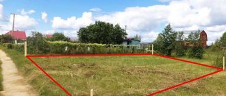
First, the necessary data is collected and analyzed. Next comes notification of citizens whose rights may be affected during land surveying. A specialist from an authorized organization goes to the site. Using special instruments, he takes measurements of the territory. For clarity, pegs are inserted into the ground to indicate the boundaries of the site. An act of surveying the boundaries of the land plot is drawn up. signed by the owners of the plot and neighbors, the engineer who is carrying out the work Draw up a boundary plan At the appointed time, the owner of the land plot can pick it up from the company that carries out the survey Submit documents and the boundary plan to the government agency To obtain a cadastral passport
This is interesting: Invalid Voyni Voyenni Travma Razmer Pensi 2020 Year of the Russian Federation
Plots are accepted for registration with the Rosreestr authorities without surveying and coordination of boundaries. A case is drawn up only in cases where there is a dispute or difficulties in establishing them. In other cases, it is enough to provide a cadastral passport or an extract from the cadastre.
Advantages and disadvantages
Before asking yourself how to survey a plot of land, it is worth considering the positive and negative aspects of this procedure.
As you know, according to the rules, no one can force a person to start this process. Therefore, now such a decision is made voluntarily, if necessary. There are certain disadvantages due to which people refuse the procedure and postpone it until later. The advantages include:
- The boundaries of the land plot are displayed in documents. At the same time, neighbors must confirm that they agree with the established boundaries. This means that in the future they will not be able to start an argument over where exactly their plot ends.
- The procedure is carried out free of charge from the municipality. Therefore, people don't have to worry about paying large sums of money to set boundaries.
- It becomes possible to carry out various transactions, including donation, inheritance, purchase and sale and rental. As already mentioned, from 2020, such an opportunity will disappear for dacha lands if they have not been surveyed.
Disadvantages also exist, and first of all, people are not satisfied with the fact that they will have to spend time and effort on the procedure. On average, this will take one and a half months, although the period may vary depending on the situation. However, the process will still have to be carried out one day, so you should not postpone it until the last minute, so as not to experience inconvenience in the future.
People are also concerned about the fact that legislation changes quite often. Therefore, owners of gardening plots decide to wait longer. Moreover, municipal specialists are not always competent enough, which also leads to difficulties.
Based on this, it is worth deciding whether land surveying is necessary for the dacha. Experts recommend that you still carry out this procedure, because it eliminates many inconveniences and allows you to avoid conflicts with neighbors. It will be useful for people who decide to start the process to know its sequence and the necessary measures.
Documents for land surveying
As mentioned above, land surveying is carried out by a special organization or person who has the appropriate license for this activity. The customer has the right to choose a specialist at his own discretion. You can contact the Technical Inventory Bureau or consult with those who have already had experience in this matter.
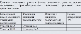
- Last names with initials of all persons interested in this issue.
- Details of passports or other identification documents.
- Results of coordination (joint or individual).
- The final diagram of the boundaries of the site indicating the coordinates.
- Objections from interested parties (if any).
- Seal and signature of the engineer who carried out the survey.
- Signatures of neighbors who expressed consent.
This is interesting: If I was Born and Lived for a Year in the Chernobyl Zone
About public lands
A garden partnership includes not only people’s plots, but also a PDO. This abbreviation can be deciphered as public lands, which include specific territories. These are roads, parking lots for technical equipment, utility rooms, ponds and passages. That is, the public lands of the SNT are an obligatory part, which cannot be dispensed with.
Not everyone considers whether their boundaries need to be defined. According to the law, land surveying of public lands is a mandatory procedure that every partnership must carry out. The process itself is similar to that carried out for plots owned by people. However, the main difference is that the responsibility falls not on the owner of the site, but on the board of SNT. It is they who should think about starting the process.
It will be necessary to convene a meeting of shareholders, where the issue of land surveying will be raised. People will need to make a decision about starting the procedure, and then start collecting contributions. Although the process is not easy, without it the state has the right to cancel the garden partnership.
Summing up, we can come to the conclusion that, although it is not necessary to survey your site, it is very desirable. In the future, many problems, especially related to transactions, can be avoided. That is why the sooner the boundaries are identified and the property is registered in the real estate registry, the better it will be for the owner. The same can be said about public lands, only in their case this procedure is mandatory.
When the surveying procedure is not necessary, but advisable:
— if land surveying has already been carried out according to all the rules, it will be very difficult to challenge its results even in court. If there was no land survey, then when resolving legal disputes it is carried out in accordance with the court decision. That is, during the process, a judicial land management examination is carried out and a decision is made on its basis. Often the court obliges the disputing parties to carry out land surveying based on its decision, since the court decision does not yet mean cadastral registration.
- to identify unused space. Gardening partnerships have undeveloped plots. During the survey, all unregistered land will be recorded by a cadastral engineer and put on cadastral registration.
— to increase the liquidity of the land plot. If the plot is registered in the cadastral register, potential buyers are more willing to make a deal. After all, in this case there will be no problems with boundaries.
— when registering land plots of complex shape. It is often impossible to determine the area of a plot without special measurements, so it is worth resorting to land surveying.
- during capital construction on a land plot. Until the land plot is registered with the cadastral register, there is no certainty that the building is not being built on a “neighboring plot”. There are often cases where it is impossible to obtain permission to operate a house due to the fact that it is located on “foreign land.” Sometimes such buildings are demolished by court order.
Survey results
The main and indisputable result of land surveying is the registration of the land plot in the cadastral register. This means that the boundaries of the site have been established, agreed upon, and claims can only be made in court. Even if there are no boundaries on the ground, or they have been destroyed, a cadastral engineer will be able to restore them with maximum accuracy any number of times.
If, after reading this article, you still haven’t decided whether the site needs to be surveyed or not, contact our specialists by phone or come to our office. We will explain in detail what to do with your documents free of charge. And don’t worry - we don’t impose our services, we offer them!
Prices of our services
When is land surveying not necessary? Land surveying without land surveying.
There are many opponents of land surveying. After all, this is an extra expense and time for preparing documents. If land surveying is not required by law, then you don’t have to do it. The desire of the state, for the money of the population, to send everyone by force to the “cadastral paradise”, where everything is taken into account and calculated, is worthy, at a minimum, of surprise on the part of the same population. After all, before, everyone managed somehow without cadastral registration. There were master plans for partnerships, plans for the development of villages, etc. But the reality is that sooner or later, all land plots will be required to be registered in the cadastral register. This can be considered a kind of additional one-time tax on land.
To confirm these words, you can read paragraph 21 of the Order No. 2236-r dated December 1, 2012, which clearly stipulates “the establishment, from January 1, 2020, of a ban (without exceptions) on the disposal of land plots for which there is no information about the location of the boundaries "
There is such a term among the “people” - land surveying without land surveying. That is, to demarcate without going through all the routine and expensive stages of “establishing the boundaries of the memory.” Let us repeat once again - by law you are not obliged to carry out land surveying if the site is “previously registered” (described above). Even if the plot is not “previously registered”, if you have been using the plot for more than 15 years and have only an old certificate or garden book, you can contact the cadastral registration authority with these documents and, under the “dacha amnesty”, receive a fresh cadastral passport (the plot will be assigned a cadastral number ) and a new certificate at the registration chamber.
This is land surveying without land surveying. That is, your property is still assigned a cadastral number (an integral part of land surveying) and data on the location and area of the land plot is declaratively entered. It's quite simple and completely free. But the boundaries remain uncertain until the owner clarifies the boundaries or undergoes a free, comprehensive survey funded by the state.
Land surveying is also not necessary if the site is already registered. In order not to survey the plot twice, order a cadastral extract or cadastral passport. If land surveying not carried out, then in the cadastral passport/extract of the land plot in the column “special notes” it will be written: “the boundary of the land plot is not established in accordance with the requirements of land legislation”, “there is no information in the land cadastre that allows one to unambiguously identify the land plot” or “The boundaries of the land plot are not defined.”
But we should not forget that lawmaking does not stop for a minute. And even if your land plot has already been surveyed, there is one caveat. If the accuracy of determining boundary marks does not correspond to the normative for a given category of land (you can look at the cadastral extract on page B6), then it will not be possible to merge, divide or redistribute the plot. It will be necessary to go through the 7 circles of hell again and clarify the boundaries of the site again. This especially often applies to residents of New Moscow - previously there was a standard of 0.3 m - now it is 0.1 m. All this disgrace is happening because the authorities change regulations and rules without particularly caring about the convenience for citizens. And again, property owners will have to pay and “run around with paperwork.”
As a result, we can say this - now in many cases there is no need for land surveying, at least until January 1, 2020. It is possible that, as with the “dacha amnesty” and “free privatization,” the authorities will revise the dates for the entry into force of the new rules, but what It really will be, we'll see.