What do you need to know about the land boundary plan?
A boundary plan of a land plot is a document that displays data about the plot and new information transmitted to regulatory authorities.
We are talking, for example, about information on dividing a plot, as well as changing boundaries and clarifying them. The boundary plan contains information about:
- Cadastral plan;
- Results of completed geodetic work;
- Information from land management documentation;
- Land ownership rights;
- Land belonging to municipal or state property;
- Formation of new plots by allocating shares in common property;
- Areas for which cadastral information is being updated.
When developing a boundary plan for a land plot, certain engineering and geodetic work is carried out. This is important for determining the real location of the land, calculating its area and securing boundaries. The finished document is certified by an official.
Who needs a land boundary plan?
Land surveying and development of a plan may be required in a number of cases. This applies to the redistribution of the original plots and the formation of new ones, as well as the division of the plot. It is possible that a cadastral error was previously made in relation to this or that land, and then a boundary plan for the land plot will also be required.
Land surveying and drawing up a plan for the boundaries of a land plot are allowed to be carried out exclusively by cadastral engineers. Our company employs just such experienced specialists, helping numerous clients draw up documents in accordance with legal regulations. All of them are certified by government agencies.
What is there in topographical terms?
For the most accurate and detailed display of the parameters of the area under study, the following information should be displayed on the topographic plan of the site:
- information about points of the reference geodetic network;
- relief and its characteristics;
- hydrography with the location of all available artificial and natural reservoirs;
- information about vegetation;
- data on the presence and characteristics of underground and above-ground communications;
- information about existing residential and non-residential buildings;
- exact location and characteristics of transport infrastructure;
- data on other objects, if any, on the site.
Order a topographic plan from the company EXACTLY
Within 5 minutes a specialist will contact you and clarify the details of the project
The correctness, feasibility, depth and methodology of design solutions depends on how correctly and completely the information is reflected on the topographic plan.
The topoplan gives a clear idea of the features of the relief, building density, hydrography and many other characteristics of the territory, which allows it to be used by specialists in almost any sector of the national economy.
The quality and completeness of design solutions largely depends on the quality and integrity of the production of the topographic plan. Geodetic has a lot of experience in the field of engineering geodesy. We create topographic plans taking into account the specifics of design of various directions, as we understand full responsibility for the completeness and quality of the basic, primary information provided to our clients.
Geodetic carries out a full range of works on compiling topographic surveys of territories for various purposes. From field work to finished products. Moreover, if necessary, our specialists will help develop the correct technical specifications for topographic surveying, taking into account the further use of the results of our work. We carry out topographic survey work on at least 100 sites annually. Most of our work undergoes expert reviews at various levels, including State Expertise structures.
Our Company employs highly qualified surveying engineers. Two of them are current members of the National Register of Specialists in the field of engineering surveys and architectural and construction design. The company's activities are fully within the framework of the existing legislation of the Russian Federation.
What is included in a land plot plan?
The land plot plan includes two parts: text and graphic. They are formed from mandatory sections, as well as sections corresponding to specific types of cadastral work.
The elements of the text part are always the title page and contents. This part also includes:
- Background information;
- Data on measurements and calculations;
- Information about changed or newly formed areas, as well as their parts;
- Data on the procedure for access to sites;
- Data on the specified areas or their formed parts;
- Conclusion drawn up by a cadastral engineer;
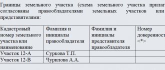
- The act of agreeing on the location of borders.
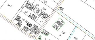
The graphic part of the land plot plan presents diagrams of geodetic constructions, land locations, data on key points of boundaries and drawings of the plots themselves and their parts.
Document design principles
The conclusion of the cadastral engineer is included in the boundary plan of the boundaries of the land plot if, during the period of work, a discrepancy between the cadastral data on the boundaries of adjacent plots, settlements or municipalities is discovered with the real situation. In such cases, errors prevent the land from being registered in the cadastral register. The person performing the relevant work may insist on additional justification for the results. This section is presented in the form of coherent text material.
The land plot plan is carried out in electronic format or on paper. The cadastral engineer can certify it with an electronic signature, then there is no need for a paper version.
If the plan is drawn up on paper, one copy is sent to the cadastral registration authorities, the rest are transferred to the customer. Such a document is stitched, it is sealed with the signature of the cadastral engineer and his seal. The seal must also appear in the act confirming the approval of boundaries.
Drawing up a topographic plan of the area: at what scale are plans created?
As a rule, we ask clients to draw up a detailed technical specification, indicating the required scale. But not everyone understands their scope of application.
The most popular scale for creating topographic documentation is 1:500. Experts in the field of geodesy often call it “five hundred”. This scale allows you to create a fairly detailed image of the area. But this scale has its drawbacks - it is convenient to use for studying small areas.
If you need to draw up a topographical plan of the area for large industrial facilities, master plans of settlements or drawings of open-pit mining, we recommend using a scale of 1:2000 or larger. Such objects do not require such detailed detailing.
To order the preparation of a topographical plan of the area in our company, you need the following documents: a passport, technical specifications, as well as documents confirming ownership of the land (if you order a topographic survey of a land plot).
How our specialists create a topographic plan: from order to technical report
Our main task when drawing up a topoplan is the accuracy of the research and efficiency. We try to complete the work quickly and divide it into 3 steps:
- preparation (we draw up a contract for services, calculate the cost, study the terms of reference);
- field work (we go to the site, make survey justification and measure the area);
- office work (calculations, drawing up graphic documents).
After the entire cycle of research, we draw up a technical report. In the report we describe:
- general parameters of the site;
- details of the work performed;
- topographic plan of the area.
We carry out work in accordance with regulatory documents and GOSTs. Therefore, our clients have no problems agreeing on documentation.
Differences between boundary plan, cadastral plan and boundary plan
A land plot plan is often confused with a boundary plan, although these are completely different concepts. The second document outlines the current boundaries of the land, their parameters, total length, as well as landscape features within the boundaries of the site. The boundary plan includes information about the newly formed areas. The process is marked here using arrows, dotted lines and other symbols. The only thing that unites the two types of plans is the accuracy of the image.
A land plot plan can be not only a boundary plan, but also a cadastral plan. There are also differences here. In essence, a cadastral plan is a map of a given area, on which information from the State Land Cadastre is displayed using graphics and text. The boundary plan can be considered a continuation of the cadastral plan and its addition. It was compiled taking into account the transformations that occurred after the registration of the cadastral plan. These changes are indicated by unifying or dividing lines.
Wakeboarding
- it's like water skiing, only on a board. A rapidly developing water sport that combines the best of water skiing, snowboarding and surfing.
Probably the most bouncy of water sports. The beauty of a wake is the jumping on the wave that a well-loaded boat provides. In fact: you have neither sea nor wind, and the amplitude of movement is limited by the length of the halyard - the rope connecting the athlete to the boat.
Wake in Russia is now developing very quickly, new wake stations appear every summer, because this is perhaps the only board and water entertainment for which the main condition in the middle zone is smooth water.
Boat.
You need to ride behind a professional wakeboard towing vehicle, the engine of which is from 300 horses and above. The boat must give the right wave, for which it must be thoroughly loaded. And the point is not only in the height of the wave, but also in its shape - a good tow gives an even wave, with which the board itself flies out.
Board.
Selected not by height, but by weight. Every good club will rent a wake, the most popular sizes are: 142 cm for men and 134 cm for women. If you are a beginner and the main thing for you is to somehow stay afloat, it is better to ask for a board that is a little larger in size than you need; and when you start mastering tricks, the weight of the board becomes important - a heavy one is more difficult to both unfold and lift into the air.
Board Substance (Liquid Force)
) — 13,000 rub.
Watson
board ) - 15,000 rub.
Fastenings.
It’s difficult to get into the wake bindings if you’re not used to them – they’re very tight. To make it easier, you need to dip your bare feet and fastenings in water and spread a drop of liquid soap on your foot.
Crepes (Liquid Force)
) — 5,800 rub.
Transit
crepes ) - 11,000 rub.
Wetsuit.
Only necessary if you are going to ride in cold weather.
Wetsuit (Pro-Limit)
) — 2,200 rub.
Life vest.
They will give it at any wake station. It is absolutely necessary - it protects against impact on the water, which becomes very noticeable at speed.
Helmet.
Saves you from a lot of trouble. When falling forward flat, people instinctively turn their face away and hit their ear; at high speed, this can damage the eardrum.
Helmet (Pro-Tec)
) — 1,900 rub.
False
. The general rule is this: beginner wakers ride “on a short leash”, advanced ones need a longer halyard.
halyard (Straight Line
) — 1,900 rub.
Where to ride:
.
Based on the landing stage on the territory of the Avangard yacht club. The station was made more for our own people, but they can give rides to anyone - you just need to call and make an agreement. Boat - 70 rub. for 1 minute or 3,600 rub. for 1 hour (with hourly payment - for large companies), equipment rental is free. Dmitrovskoe highway, turn to Khlebnikovo, then 2 km to the Avangard yacht club 8, wakebrothers.ru
A floating house at the end of the pier on the territory of the Stroginsky yacht port. Equipment rental is free, boat costs 60-70 rubles. for 1 minute, lessons with an instructor - 400 rub. for 1 lesson. Tvardovsky, Vlad. 16, next to the rescue station of the Ministry of Emergency Situations, metro station "Schukinskaya", then bus. 640, 652 8, stroginowake.ru
The station is on the territory of the Crocus yacht club - right behind Crocus City. Equipment rental is free, boat - 70 rubles. in 1 minute 66th km of the Moscow Ring Road, Crocus City shopping center, Tushinskaya metro station, then bus. 631, 640 8, wakeschool.ru
The station is in Orekhovoy Bay, side by side with the Marabou windsurf club. Equipment rental - 5 rubles. for 1 minute, boat - 40-70 rubles. in 1 minute. Pirogovskoye Reservoir, 8.5 km from the Moscow Ring Road along Ostashkovskoye Highway, along the main road following the signs to Pirogovo, then to the Boltino gardening partnership 8, wakeboardclub.ru
Station on the Pirogovskoye reservoir. There is a hot shower and toilet, a bar, a cafe with dastarkhans, and a fireplace. One of the optional joys is Wi-Fi. Pirogovskoye Reservoir, 8.5 km from the Moscow Ring Road along Ostashkovskoye Highway, along the main road following the signs to Pirogovo, then to the Boltino gardening partnership 8, surfsport.ru
Station on the Istra reservoir. You can bring non-skating family members here: there is a volleyball court, barbecues and an excellent beach.
Solnechnogorsk district, village. Friday, recreation area "Sosnovy Mys" 8, surfline.ru
Friendly surfing and kiting community. There is a hotel nearby and a camping site.
63rd km of Leningradskoye Highway, before reaching Solnechnogorsk, turn right at the sign “Senezh”, then 3 km 8, ozero-senej.ru
Sources:
- bg.ru - “Big City” magazine, article “Marine Moscow” in No. 16 (187) dated 08/01/2007;
Wikipedia - about wakeboarding, equipment;
is a community of people united by wakeboarding and more...
Additionally on the topic:
kite surfing , diving , yachting .
The procedure for obtaining a boundary plan of a land plot
If you have a need for a land survey plan, you need to contact an organization that specializes in surveying and land management work. The activities of a cadastral engineer are divided into several stages:
- Collecting data about the site and studying it;
- Notifications of organizations and citizens whose rights are affected during land surveying
- Agreeing with them on all issues, including the boundaries of the site;
- Geodetic survey;
- Processing the results;
- Preparation of a land plot plan with subsequent registration;
- Transfer of documentation to cadastral registration authorities;
- Obtaining a cadastral passport, as well as an extract with the coordinates of the site.
If, at the stages of surveying or agreeing on the location of boundaries, disputes arise that cannot be resolved, the landowner will have to resolve them in court. True, this can only be done after the cadastral engineer has drawn up a document such as an approval act.