Home / Land, dacha, construction / Documents and legislation / Land plot / Cadastral registration / Number
Back
Published: 01/25/2018
Reading time: 4 min
0
2176
Each registered land plot is assigned a cadastral number. Knowing this number, you can quickly find the site on the Rosreestr map and get acquainted with all the information about it. However, citizens, when purchasing land, sometimes encounter the concepts of conditional and old cadastral numbers.
- Conditional number
- Old cadastral number
- Instructions: how to find out the new cadastral number of a land plot from the old one
Land Cadastre Law: innovations from January 1, 2020
The authorities continue to make changes to the legal framework aimed at streamlining relations in the land sector. Officials intend to minimize the number of illegal plots, which will have a positive impact on tax revenues
. In addition to legalizing land plots, the authorities plan to fix the existing boundaries of plots by making appropriate changes to the state cadastre.
From January 1 next year, a ban on the disposal of land plots for which the location of the boundaries has not been determined comes into force. Owners of land plots who do not survey their plots in a timely manner will be deprived of the opportunity to sell or donate their plots. At the same time, the existence of property rights will not affect the principle of operation of this norm.
. Owners of plots who registered their plots for cadastral registration before 2008 (when this procedure was not mandatory) are also required to carry out land surveying.
After successfully completing the land surveying procedure, the owner of the plot receives a cadastral extract. According to expert estimates, more than half of the plots that are on the cadastral register remain with unspecified boundaries
. This situation is also related to the simplified registration procedure established in the “dacha amnesty”.
The “dacha amnesty” mechanism was developed for simplified registration of land plots. In particular, owners who did not have a full package of title documents took advantage of the amnesty
. At the same time, land surveying during cadastral registration was optional, which will become a problem from January 1, 2020. Owners who took advantage of the simplified procedure without land surveying will have to fix the boundaries of their land plots by the end of this year.
Officials emphasize that the adopted innovations will help restore order in the land sector. The lack of land surveying leads to frequent disputes between neighbors, which have to be resolved in court. Ordinary owners of land plots who do not go through the land surveying procedure may lose their plots.
Does the cadastral number change when the owner changes?
Employees of this institution check the documents provided by the applicant and have the right to refuse registration if inconsistencies are identified. Citizens can also contact the territorial MFC. In this case, the cadastral registration process is slightly delayed, but the applicant will avoid the queue. The cadastral number contains information about the house, apartment, plot, etc.
In it you can “read” the location region, address and other data. The numbers are not repeated, they are unique. In addition to the obvious information, data on other characteristics is entered into the database: area, number of floors, information about the owner.
As long as no data has changed, the cadastral number remains the same. If for some reason the property is liquidated, this entails the cancellation of the unique code that was previously assigned. Information about the termination of existence is also entered into Rosreestr. When the characteristics of an object in kind change, the cadastral number also changes.
Today there is a promotion - consultation of lawyers and advocates 0 - rubles. hurry to get an answer for free→
“Processing of personal data” - any action (operation) or set of actions (operations) performed using automation tools or without the use of such means with personal data, including collection, recording, systematization, accumulation, storage, clarification (updating, changing), extraction, use, transfer (distribution, provision, access), depersonalization, blocking, deletion, destruction of personal data.1.1.4. “Confidentiality of personal data” is a mandatory requirement for the Operator or other person who has access to personal data to not allow their distribution without the consent of the subject of personal data or the presence of another legal basis.1.1.5.
“Site https://online-sovetnik.ru” is a collection of interconnected web pages located on the Internet at a unique address (URL): https://online-sovetnik.ru, as well as its subdomains.1.1. 6.
Consequences for site owners
Failure to survey or register a plot of land in the Unified State Register may be grounds for loss of property rights. The court may recognize such a land plot as “no man’s”
. In this case, local authorities will be able to dispose of the site.
After the corresponding court decision, the “former” owner of the land plot will not be able to sell, exchange or donate his plot. Also, ownership of such a plot cannot be inherited.
In addition to mandatory land surveying starting in 2020, land owners need to take into account other changes in the cadastre that will remain relevant next year. First of all, this concerns the assessment of sites on the basis of which the amount of tax will be calculated.
Next year, government agencies will assess the sites. At the same time, the cost of the plot will be as close as possible to the market price, officials emphasize. Previously, the assessment of plots could be carried out by contract workers who represented an independent party
.
Representatives of the government apparatus will be interested in the maximum assessment of the site, experts emphasize
.
In some cases, ordinary owners will have to defend their interests in court
. Otherwise, taxes will be calculated on the value recorded in the state cadastre.
The transition to cadastral value will lead to an increase in budget revenues. The economic crisis and falling oil prices have led to a sharp increase in the budget deficit
. Among other things, the budgets of the regions, which depended on the amount of tax revenues, were under attack.
When determining the cadastral valuation, various factors are taken into account that help to get as close as possible to the market value. Regions retain the right to use a differentiated approach when determining the tax rate
. As a result, local authorities received a tool that allows them to increase budget revenues.
Starting next year, owners of land plots will face further innovations that may limit the rights of owners. Problems await owners who do not timely record the boundaries of their plots in the land cadastre
. In this case, the court may recognize the land as “no man’s land,” and the ex-owner will lose the right to dispose of his plot.
The transition to cadastral value will have a positive impact on local budget revenues. In 2020, cadastral valuation will be carried out exclusively by government agencies
. If the owner of a land plot considers the cadastral value to be inflated, then he will have to challenge the assessment in court.
Watch the video about mandatory land surveying until 2020:
What is it and what does it mean?
In Soviet times, there was no need to officially register your real estate in the cadastral register, since any real estate objects were owned by the state.
Today, using a unique real estate identification number, any citizen can, if necessary, confirm that he has ownership rights to a land plot.
In this regard, determining the cadastral number may be required:
- when purchasing or selling real estate;
- when registering the right of inheritance or donation;
- to prove your own property rights in court in the process of conflict situations;
- in order to rent out real estate.
Thus, the cadastral number is the most important point when conducting any transactions with real estate, and without assigning the specified number, transactions with such property become impossible in principle.
The resulting cadastral passport, which is issued after receiving all the documents, includes quite extensive information about the land plot in question. For example, there is information here about who is the owner of the land plot, what area the specified territory has, what number it is assigned and
cadastral value
.
If for any reason a person does not agree with the results of the cadastral assessment, he can always contact government authorities to change it, but for this he will need to collect other documents.
The received passport is the main document issued for the land plot, since it confirms the ownership of the territory of a certain citizen, and also ensures the identification of real estate.
If any conflict situations arise, it is this certificate that will make it possible to determine the ownership of a particular citizen.
Sample cadastral passport of a land plot
Does the cadastral number change when the owner changes?
Employees of this institution check the documents provided by the applicant and have the right to refuse registration if inconsistencies are identified. Citizens can also contact the territorial MFC.
In this case, the cadastral registration process is slightly delayed, but the applicant will avoid the queue. The cadastral number contains information about the house, apartment, plot, etc.
In it you can “read” the location region, address and other data. The numbers are not repeated, they are unique.
In addition to the obvious information, data on other characteristics is entered into the database: area, number of floors, information about the owner. As long as no data has changed, the cadastral number remains the same. If for any reason the property is liquidated, this entails the cancellation of the unique code that was previously assigned.
Information about the termination of existence is also entered into the Rosreestr. When the characteristics of an object change in kind, the cadastral number also changes.
Why do you need to change
The conditions under which it may be necessary to make adjustments to the cadastral number or completely cancel this parameter are prescribed in Federal Law No. 221, which was adopted in 2007.
Thus, amendments are made to the state register only in exceptional situations, that is, when any changes occur related to the land plot itself, or when the territory is endowed with new properties.
At the same time, a change of owner cannot be considered as a basis for changing the cadastral number, because the key properties of the land plot continue to remain unchanged.
Some modifications of the characteristics of a land plot require submitting an appropriate application to Rosreestr to make changes to the state cadastre, but as a result of the operation the cadastral number will not change. In particular, this applies to the construction of new buildings on the territory of a land plot or changes in its cadastral price.
Does the cadastral number change when the owner changes?
Employees of this institution check the documents provided by the applicant and have the right to refuse registration if inconsistencies are identified.
Citizens can also contact the territorial MFC.
In this case, the cadastral registration process is slightly delayed, but the applicant will avoid the queue.
The cadastral number contains information about the house, apartment, plot, etc. In it you can “read” the location region, address and other data.
The numbers are not repeated, they are unique. In addition to the obvious information, data on other characteristics is entered into the database: area, number of floors, information about the owner.
As long as no data has changed, the cadastral number remains the same. If for any reason the property is liquidated, this entails the cancellation of the unique code that was previously assigned.
Information about the termination of existence is also entered into the Rosreestr. When the characteristics of an object change in kind, the cadastral number also changes.
How does the cadastral number of a land plot change?
Today, state registration of real estate is carried out by authorized employees of Rosreestr, and therefore, in order to make adjustments to the cadastral number of a land plot, you need to contact the territorial office of this body located at the location of the plot of interest.
To clarify the address of regional offices, you can go to the official website of the specified department. Also, if necessary, all necessary documents can be submitted to the multifunctional center or online on the official website of the department.
The documents that will need to be provided to make adjustments to the state register are as follows:
- the applicant's civil passport;
- an extract made from the state register;
- completed cadastral passport and boundary plan;
- a decision made by a territorial administrative body to change the address of the specified real estate, transfer a land plot to another category, or carry out any other actions due to which there is a need to change the cadastral number;
- technical plan drawn up for any real estate located within the land plot.
Regardless of the circumstances, the owner will be required to fill out an application form, on the basis of which adjustments will be made. This document can be filled out when visiting Rosreestr or in advance.
The provision of the public service itself is absolutely free, and payment of the state fee is provided only if the property owner needs to obtain a new extract from the state register.
The procedure for changing the number followed by making amendments to the state register must be carried out within 18 days, but if the application is submitted by mail or through a multifunctional center, the period may increase by the time required to deliver the notification through the postal service or using a multifunctional courier center, and will be from 21 to 25 days.
Land owners can constantly monitor the processing status of the submitted application online using the received number.
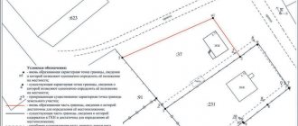
Sample boundary plan:
Where to contact
As mentioned above, applications are considered at the territorial office of Rosreestr or through a multifunctional center. The latter body is a simple intermediary between government agencies and ordinary citizens, and its employees are not involved in reviewing submitted documents or making any decisions.
In this regard, contacting this body is carried out only if it is more convenient than submitting a full package of papers to the territorial office of Rosreestr, since the procedure for processing documents through the MFC will take longer.
Cost of the procedure
In addition to all the necessary operations, the interested person will have to pay the state fee provided for by current legislation. The amount of this fee will vary depending on who is applying for a government service and why it is needed in general.
Thus, legal entities pay a state fee of 1,000 rubles, while individuals may be limited to a fee of 100 rubles.
At the same time, the electronic version of the passport provides for an additional payment of 50 or 300 rubles for individuals and legal entities, respectively. If the interested person orders the specified document in paper form, its cost will already be 200 and 600 rubles for individuals and legal entities, respectively.
Does the cadastral number change when the owner changes?
Employees of this institution check the documents provided by the applicant and have the right to refuse registration if inconsistencies are identified.
As long as the object itself has not changed, the number will not change. In order to organize all the information about apartments and houses by address, it is necessary to assign each object an individual number, which is called a cadastral number. It is displayed in digital format in registers and documents.
Citizens can also contact the territorial MFC. In this case, the cadastral registration process is slightly delayed, but the applicant will avoid the queue. The cadastral number contains information about the house, apartment, plot, etc. In it you can “read” the location region, address and other data.
The numbers are not repeated, they are unique.
In addition to the obvious information, data on other characteristics is entered into the database: area, number of floors, information about the owner.
As long as no data has changed, the cadastral number remains the same.
If for any reason the property is liquidated, this entails the cancellation of the unique code that was previously assigned. Information about the termination of existence is also entered into the Rosreestr.
When the characteristics of an object change in kind, the cadastral number also changes.
What to do if Rosreestr independently assigned a different code to the plot
Correction of such technical errors is carried out in accordance with Article 28 of Federal Law No. 221, adopted on July 24, 2007. As a result of making appropriate adjustments to the information specified in the state cadastre, in the future, data on the previously recorded site will be transferred to the correct cadastral quarter.
These standards are spelled out in Rosreestr letter No. 14-9519-VK, which was published on November 17, 2009.
A cadastral number is assigned to each land plot included in the state real estate register (USRN). It allows you to clearly identify the land plot
. Typically, a number is assigned to a site at a time and cannot be changed. But sometimes situations arise that require owners to take active action to change the current cadastral number.
How to change the cadastral number?
Rosreestr maintains state records of real estate in Russia. This is where you need to go to make changes.
.
The application is submitted to the territorial office of Rosreestr at the location of the land plot
.
You can find out the addresses of regional offices and authorized branches for accepting applications directly on the department’s website.
If you want to find out how to solve your particular problem, call the following numbers: Moscow +7(499)350-66-30 , St. Petersburg +7(812)309-36-67 .
Other ways to make changes is to transfer documents through the MFC or by Russian post. Rosreestr also allows you to send an application in electronic format through the website.
The documents required from the applicant to amend the State Tax Code will depend on the specific situation. This list may include:
- Applicant's passport and power of attorney to represent interests (optional).
- An extract from the Unified State Register of Real Estate (it must, among other things, confirm the ownership rights to the applicant’s land).
- Boundary plan and cadastral passport.
- The administration’s decision to change the address, transfer land, clarify their intended use.
- Technical plan for the located buildings.
In any case, the owner will be required to fill out an application form for making changes. It can be filled out directly during a visit to Rosreestr or in advance. The application must include:
- name of the Rosreestr body;
- the reason that prompted the owner to make changes (what characteristics of the site have changed);
- information about the applicant;
- list of attached documents;
- consent to the processing of personal data;
- preferred method of receiving a decision on the application (in person, by mail or through a representative).
statements you can
Here
.
The edits themselves are made free of charge. The state duty is paid only if the owner needs to obtain a new extract from the Unified State Register of Real Estate.
The department will have 18 days to change the number and make amendments to the State Tax Code. But when submitting an application by mail or through the MFC, the specified deadlines can be extended by the time the notification is delivered by the postal service or MFC couriers up to 21-25 days
. Land owners will always be able to track the status of application processing online using the number issued to them.
During the specified time frame, the owner may be refused to register changes (for example, if factual errors and inaccuracies are found, or documents are incomplete).
Does the cadastral number change when the owner changes?
Employees of this institution check the documents provided by the applicant and have the right to refuse registration if inconsistencies are identified. Citizens can also contact the territorial MFC. In this case, the cadastral registration process is slightly delayed, but the applicant will avoid the queue.
The cadastral number contains information about the house, apartment, plot, etc. In it you can “read” the location region, address and other data.
The numbers are not repeated, they are unique. In addition to the obvious information, data on other characteristics is entered into the database: area, number of floors, information about the owner.
As long as no data has changed, the cadastral number remains the same.
How is a cadastral number canceled?
In a situation where the owner becomes aware of the cancellation of information about a land plot and its exclusion from the State Property Committee, he needs to take measures to register the plot with Rosreestr. Only in this way will he be able to legitimize his rights to the land.
This procedure involves going through the following steps:
- Collection of the necessary set of documents. The list of required documentation includes: the applicant’s passport; boundary plan drawn up by a cadastral engineer; application for registration of the site. The specified list of documents is not exhaustive and can be supplemented taking into account the specific changes.
- With the presented set of documents, you must contact the Rosreestr branch, the MFC (pre-registration for an appointment is allowed) or send them electronically using the government services portal. This service is provided free of charge.
- Receive an extract from the Unified State Register of Real Estate, confirming the assignment of a cadastral number and the introduction of changes to the State Tax Registration Number.
Thus, when canceling the cadastral number, the user must re-register the land, since there is no possibility of restoring information from the State Property Committee.
Dear readers, the information in the article may be out of date, take advantage of a free consultation by calling: Moscow +7(499)350-66-30 , St. Petersburg +7(812)309-36-67 .
In recent months, one could see how many cadastral engineers almost unanimously argued that if the land plot is not surveyed before January 1, 2020, then the owner of the property right will lose the right to use his own land plot. Rosreestr had to urgently reassure citizens and give some explanations why this excitement arose.
Does the cadastral number change when the owner of the apartment changes?
For example, when land plots are divided or merged, their numbers change.
However, as long as the apartment and the building in which it is located are intact, the number remains the same. A change in the owner of an apartment does not mean that the cadastral number will be changed. Actually, the cadastral number serves as an identifier for real estate, including residential ones.
Along with the actual address, it is the number that allows you to distinguish two apartments of the same type from each other.
If data in electronic and paper media have discrepancies, when identifying them, preference is given to paper ones. Registration authorities that
Everything remains the same, but you need to be vigilant
First of all, Rosreestr explained that land surveying from January 1, 2020 will be carried out on a voluntary basis, as before, and no one will take away a land plot, even if you did not have time to go through this procedure before December 31, 2020. The second sign of excitement was most likely caused by the fact that cadastral engineers decided to interpret the law on land plots and the new law on cadastral real estate in their own way. The third sign is banal greed; cadastral engineers still wanted to make money from the legal illiteracy of the population.
Land surveying from January 1, 2020
Further, Rosreestr says that the new Federal Law-18 does not indicate anywhere about the timing of land surveying, which means that everything remains as before, but still, there is a certain recommendation on what needs to be done with the land plot after this period. An official representative of Rosreestr even pointed out the fact that Rosreestr does not speak anywhere on the website or in public statements about mandatory land surveying.
If your extract contains no information about actual land surveying, then you can easily go through this procedure after January 1, 2020, and the state will not apply sanctions to land owners.
Where did the rumors about urgent land survey come from?
Meanwhile, there remain a number of factors under which land surveying will still need to be carried out without fail from 2020, regardless of the actual status of the land:
- You have a dispute with your neighbors or the state is making claims on a plot of land.
- During the sale without land survey, one of the parties made a claim to the land plot.
Figuratively speaking, land surveying is necessary if there is some kind of dispute with one of the parties. In addition, you can sell your plot of land next year without surveying, but the lack of surveying can play a cruel joke on the new owner due to the fact that someone will make a claim
.
Therefore, Rosreestr gives only RECOMMENDATIONS for carrying out land surveying on a voluntary basis
. Thus, you will fix the coordinate points of the object of law for all occasions.
Land surveying in 2020
Who does land surveying
The land surveying procedure is within the competence of cadastral managers. You can find the “Cadastral Register Engineer” section on the Rosreestr website, where you can select a suitable specialist from the list. In the register you can study the specialist’s data, as well as read reviews about him.
Stages of land surveying
The surveying procedure itself includes the following:
- Establishment and precise determination of coordinate points of the land plot.
- Attaching boundary markers to the site.
- Accurate determination of the area of land.
- Formation of a refined boundary plan, as well as completion of a topographic drawing, including based on aerial photography data.
- Entering data into the Roskadastre database.
This is the basic procedure for carrying out boundary work.
Stages of land surveying in 2020
How can an owner go through the stages of land surveying correctly?
The survey period may take up to 2 months; this is the maximum period determined by the cadastre law in the Russian Federation. In any case, during the land surveying process various changes in configuration and changes may occur. Coordinate points, by rotation angles
. Ultimately, you will officially secure your data in the Rosreestr database, and no one will be able to encroach on your land plot.
The land surveying stages themselves take place according to a specially approved scheme:
- We prepare the required package of documents in 2 copies for the geodetic service.
- An act is being developed to determine the coordinate points of the land plot, the signatures of the land owner, neighbors, government representatives, as well as the specialist who is conducting the work are signed.
- We receive one of the copies from the official master plan form.
- We present a document confirming the absence of arrest (in some cases this is not required, you need to check with a specialist).
- Carrying out geodetic survey of the area.
- Installation of boundary signs (special symbols in the form of flags or other identification marks).
- Drawing up a boundary plan that is submitted to Rosreestr.
- Receiving a new extract from the Unified State Register of Real Estate, indicating the new coordinate points of the land allotment.
Thus, you legally secure the right to the boundaries of a plot of land, and in the future you can dispose of your property at your discretion.
Remember that land surveying is voluntary, but if you don’t want problems in the future, we recommend that you do not put the matter off, but order land surveying from a specialist who will carry out the work in accordance with the requirements of Russian cadastral legislation.