With the onset of 2020, the right to dispose of a land plot without restrictions, without prior land surveying, will become limited, and this condition applies to everyone, including its owner. This term refers to the exact designation of the boundaries of the site, which were previously established in approximate form. Today, the law on land surveying assumes that in order to put the situation in order, it will be necessary to carry out a whole range of works related not only to geodesy, but also to their legal registration.
Description of the law
The regulation of all aspects related to land surveying is dealt with by such a document as the Land Code. These aspects are directly contained in its 11th article, and the most recent changes and additions were made by Federal Law 361-FZ. In particular, this law states that during the procedure for registering a disputed site in the federal register, land surveying is mandatory, without which this process is impossible. The conditions for the demarcation were determined by the Federal Law “On State Registration of Real Estate” N 218-FZ, adopted in 2013.
Land surveying is one of the mandatory procedures that can be used to determine whether the owner owns his land; the legislation does not provide for other options for resolving this issue.
With the onset of 2020, without carrying out the land surveying procedure, it will no longer be possible to carry out actions with a land plot to change its owner.
Land surveying and registration of a new cadastral passport for the land in 2018-2019
What is required now from land owners? What documents are needed and is it necessary to obtain a cadastral passport and survey a plot of land at the dacha?
Land surveying and registration of a new cadastral passport is necessary for owners of land plots if the owner intends to sell his possessions. What is required now from land owners? What documents are needed and is it necessary to obtain a cadastral passport and survey a plot of land at the dacha?
Let us also remind you that the law on registration of citizens in houses on garden plots will come into force in 2020.
On January 1, amendments to the law on state registration of real estate came into force, according to which all so-called turning points on a land plot must be indicated in the cadastral passport. They indicate the boundaries of the site. This information must be up-to-date and not just formal.” Without a cadastral passport, Rosreestr simply will not register the transfer of ownership.
“If the owner of a garden or vegetable plot plans to sell it, then it is necessary to carry out land surveying and update the cadastral passport,” says the lawyer.
If the landowner has not carried out the land surveying procedure, he will have an old passport, possibly even with a note that the exact boundaries of the land plot have not been determined. When selling real estate with such a cadastral passport, a lot of problems will arise. Firstly, many people will simply refuse to buy a plot without up-to-date documents for it. And secondly, even if the buyer does not know all the intricacies of the law, he will learn about them when registering the transaction. It will also be impossible to inherit a plot with an old passport.
The concept of land surveying
Indicating the boundaries of a land plot using special signs and preparing a corresponding plan is the definition of the concept of “land surveying”. It is in many ways similar to cadastral activities, but between these terms, despite their similarity, there are differences. First of all, it is necessary to understand that land surveying is an integral part of cadastral activities, which is the preparation of certain documentation necessary for the implementation of the entire procedure.
Land surveying becomes mandatory for the following situations:
- when property is transferred from communal or municipal property to private hands;
- when performing operations on the division of land plots;
- when combining two or more plots;
- when carrying out the process of land redistribution.
Mandatory land surveying from 2020
Although the corresponding law was adopted on December 22, 2014 (No. 447-FZ), many Russians have not ordered land surveying until now. And you can really do without it if:
- the land has already been registered as a property;
- the owner does not have and does not foresee disputes with neighbors about the boundaries of the plots;
- In 2020, no transactions with real estate are planned (sale, rental, donation, etc.).
If the owner nevertheless decides to conclude a real estate transaction, it will be possible to establish boundaries even after January 1, 2020. It turns out that you don’t have to worry about what will happen if you don’t survey the land plot before the coming New Year holidays? Yes and no. Experts recommend not delaying clarification of the boundaries of a land plot, if only because when land surveying turns from voluntary to mandatory, the price of this service will increase.
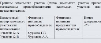
Sample boundary plan of a land plot
A boundary plan may look like this: This document can serve as a visual confirmation of the fact where the boundaries of garden or summer cottage plots are laid. It can also be submitted to the court for the consideration of disputed cases regarding property.
Typically, orders for land surveying come from those owners of plots who have disputes about the boundaries between them. At the same time, there is often a misconception that in order to resolve disputes it is enough to wait for a cadastral engineer who will perform all the required measurements and thereby solve the problem. In reality, everything is different, a cadastral engineer can only record where exactly the boundaries lie, and the owners themselves must either reach an amicable agreement among themselves or go to court to resolve the dispute.
What lands should be surveyed?
It turns out that the procedure is recommended for owners of any type of land that is officially owned. Why does such a serious decision have official status? Initially, it is important to note that in the Russian Federation there are indeed many land plots occupied by capital structures that have not undergone official registration. That is, no one paid land tax from them. Just count that in the Moscow region over the past year there were about 600 thousand of them, and in the state the figure will be definitely higher.
This is interesting: Ways to refuse inheritance
Most of the land belongs to gardening partnerships, vegetable gardens, dacha cooperatives, and was issued to company representatives back in Soviet and post-Soviet times. Only those owners who have drawn up documents in the past and have the corresponding act in their hands can not worry about the need to draw the boundaries of the territory. If you do not have this document stored in the archives, or you recently purchased the land, you need to request an extract from the state register for the territory, and based on its results, make a decision whether the procedure is required or not.
How to draw up a land survey plan for a multi-circuit area?
Multi-circuit areas are those consisting of at least two closed parts. This type of plot is divided into two groups:
- areas consisting of two or more contours;
- areas that have inclusions within them.
The last option is very common among rural residents, when on opposite sides of the road there may be a residential building with outbuildings and a vegetable garden. In fact, we are talking about two different areas, but the document is drawn up and issued for one, but the boundary plan must contain an indication of such a division. In addition, it must indicate all the initial data of the specified territory. It should be noted that the assignment of a number applies to the entire plot, regardless of the number of its components; individual plots cannot receive their own number.
Documents for land surveying
Only those organizations that have a license for land management and geodetic work can carry out this procedure. It can only be carried out on the basis of an officially concluded agreement.
To complete the application, the following documents are required:
- the applicant's identity card;
- confirmation of land ownership;
- a copy of the general plan of the area;
- site plan and its cadastral passport.
Everything looks quite simple and even easy, but only in theory. In practice, one often encounters serious difficulties and problems. First of all, the human factor can play a negative role, because relations with neighbors are not always good and the lack of clearly defined boundaries of the site can become a real stumbling block in this matter. There are cases when real wars break out over just a few centimeters of land. Many people act on the principle “whoever got it first is right,” so situations may arise when, during the land surveying process, it turns out that a piece of territory has already gone to a neighbor. As a result, you have to participate in long proceedings and in courts, and with far from clear chances of a positive result.
Has the dacha amnesty been extended until 2020 or 2020?
There is a separate article in the Federal Law stating that the clarification of the boundaries of the site must be agreed upon without fail with interested parties, which are the neighbors. The question is, what do you lose or what do you gain when agreeing, but more on that below (about the benefits of land surveying). You can notify your neighbors either by mail or by organizing a general meeting. And it will be better to do this before 2020. Although the process itself is simple, and if the site belongs to shared ownership, then it is better to go through all stages of the procedure as advised in the Cadastre. You must definitely advertise in the newspaper that you want to separate from the partnership. If, after notification by mail, no contradictions are received within a month, then land surveying can be carried out without much difficulty. The same applies to the decision of the general meeting of shareholders.
Is the procedure mandatory?
If the owner of a land plot does not want to carry out land surveying, then he has the right to do so, but it should be taken into account that in this case he will not be able to perform any actions with it to change the owner (donation, sale, inheritance, pledge, and so on). The Law “On State Registration of Rights to Real Estate” states that in order to obtain title documents, information about the boundaries of the plot is mandatory, therefore, it will not be possible to do without land surveying.
What it is
Land surveying, or in other words, establishing the boundaries of an allotment, is carried out by geodetic companies specializing in this issue in several stages. First of all, the boundaries are determined on the ground. Then special signs are installed on the boundaries. Based on the data obtained, a detailed plan of the site and its surrounding lands is created. Upon completion, this paper must be certified.
The determination of the boundaries of the plot is carried out before making transactions with land. You will not be able to sell a plot that is not registered with Rosreestr. Rosreestr, in turn, requires a cadastral passport for the land, in which the boundaries of the site must be precisely defined, based on the survey carried out.
For quite a long time (during the USSR, and even in the first years after its collapse), land surveying was not carried out. The plots were transferred for lease and perpetual use, taking into account cartographic data, which often turned out to be inaccurate. Since the law on land surveying does not have retroactive effect, no claims are made against such plots. However, transactions at the moment must be carried out according to all the rules.
Changes in the law on land surveying
In accordance with the new changes made to the text of the law “On State Registration of Real Estate” dated July 13, 2015 N 218-FZ, “from 2020 land surveying becomes a procedure that is now mandatory. If you refuse to carry it out, then no real estate transactions involving a change of owner will be possible. This is directly indicated by paragraph 1 of Article 19 of this document.
The law has also undergone other changes, in particular, Article 22 now states that the basis for the boundary plan is the cadastral plan. Such a document consists of two parts: text and graphic, the first contains information about the site and its buildings, the second represents the territory in question, marked by boundaries.
Land surveying after January 1, 2020
Land legislation has undergone major changes in recent years. On January 1, 2020, the provisions of Federal Law No. 217 of July 29, 2017 came into force, which require registration of lands belonging to SNT and ONT. The concept of dacha partnerships has been abolished in the law.
Registration of lands and buildings on them can be carried out only on the basis of a boundary plan. Therefore, land surveying becomes necessary. Especially for those who are planning to build a residential building on a garden plot. To build it, you will need not only to register the land, but also to obtain a building permit.
Changes for 2020
Changes in the Land Code came after amendments dated June 1, 2015. In order to reduce unregistered territories and to organize information about areas, authorities received the right to clarify their boundaries independently. Thanks to this decision, there was an increase in tax revenues, since people pay for the land that actually belongs to them. What is important here is the fact that such land surveying is carried out at the expense of budgetary funds; the owners do not have to pay anything during its implementation.
How to produce
Changes are constantly being made to the Land Code of the Russian Federation. Therefore, when talking about the procedure for marking the boundaries of a land plot, one should build on the latest amendments dated June 1, 2015.
Instructions 2020
The procedure itself (and it is now clearly fixed) will be discussed further. The main news that shocked many landowners was the cancellation of the dacha amnesty, which we mentioned above. Municipalities will consistently and carefully carry out land surveying of the lands under their jurisdiction. Starting from 2020, it will be impossible to make any transaction with undemarcated land.
Thanks to the changes made to the legislation by the new law from June 1, 2020, at the request of the municipality, free land surveying is possible under the “dacha amnesty”.
Citizens are given 15 years to challenge the decision of surveyors in the event of claims against established boundaries.
A useful video about the new instructions for conducting land surveying from 2020 and the cost of the event awaits you below:
Next, we will tell you where to get a land survey plan.
Where to get a site plan
The cadastral plan is the most important document issued by the Cadastral Chamber (CP) for the site. However, it is entirely built on the basis of a boundary plan. Thus, the design of a plot and its registration become impossible without defining the boundaries.
The same Cadastral Chamber is responsible for drawing up the boundary plan. There they will advise you which geodetic company is best to contact to carry out land surveying. The data established by geodetic engineers is subject to approval by the Committee in charge of land relations. After which a boundary plan is created.
In addition to approval by the aforementioned Committee, it is necessary to obtain the consent of the owners of the plot itself and their neighbors to secure the established boundaries.
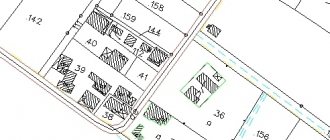
You can view a sample boundary plan in the attached file.
Sample land surveying project
Sample land surveying project - 1
Sample land surveying project - 2
Sample land surveying project - 3
Sample land surveying project - 4
Sample land surveying project - 5
Sample land surveying project - 6
Sample land surveying project - 7
Sample land surveying project - 8
Sample land surveying project - 9
Sample land surveying project - 10
Sample land surveying project - 11
Sample land surveying project - 12
Sample land surveying project - 13
Sample land surveying project - 14
Sample land surveying project - 15
Procedure and documents
So, to carry out land surveying, you should perform a number of actions:
- collect documents for the allotment, including title papers;
- contact KP for the provision of geodetic services;
- invite an appointed engineer to carry out measuring work on the site;
- collect documents for submission to the CP;
- pay the fee established by the state;
- submit the collected papers;
- wait for the result.
As for documents, a complete list will be given to you in the CP. However, they will necessarily include:
- Passport and its copies (documents of all owners will be required);
- Documents for the land, including survey results;
- A receipt confirming that you have paid the state fee.
A well-known lawyer will talk about the specifics of the land surveying procedure, sample acts and other important nuances of the event in the following video:
Next, we will talk about how much it costs to survey a plot of land.
Deadlines for land surveying according to law
According to legal requirements, after informing the owners of neighboring plots of their intention to leave the partnership and carry out land surveying, at least 30 days must pass. This time is allotted to them to make a verdict on agreement or disagreement with the proposed work. A period of 1 to 5 days is allotted for carrying out geodetic work; measurements may require a lot of time due to weather conditions or landscape features of the site.
Having received the result, the customer must provide information to the state register and register ownership rights. This takes from three to six months, depending on the complexity of each specific case.
The period for which land surveying must be carried out
How to carry out land surveying? The entire legal basis for mandatory activities, including the preparation and conduct of land surveying, can be read in Federal Law No. 221 dated July 24, 2007. A number of amendments have been introduced to it, which came into force on January 1, 2020.
Let's mark all the stages sequentially:
- Preparation of all necessary documents. These include: civil passport of the owner of the site; SNILS; documents confirming land ownership, as well as, if necessary; power of attorney. If a plot of land does not have a connection to centralized communications, then certificates about this will be required from the relevant services.
- Finding a cadastral engineer and concluding an agreement with him to carry out land surveying work. It’s worth going into more detail here.
We suggest you read: What is the guarantee for LED lamps?
Only a specialist can carry out the process of setting the boundaries of the site, its area and exact location. This is what a cadastral engineer is. This can be any person (individual, legal entity or individual entrepreneur), but must have an official document. A certificate issued and registered in Rosreestr is confirmation that he has sufficient qualifications to provide such a service.
To obtain such a certificate, candidates are subject to a number of requirements: they must have a professional education, as well as pass exams to confirm their qualifications. In addition, the engineer will be allowed to work independently only after a two-year internship as an assistant cadastral engineer with experience.
It should be noted that the quality of work of such specialists has improved as a result of successful reforms in this area.
- After concluding the contract, the cadastral engineer goes to the site where he records the coordinates of the points on the site. Then, based on the instrument readings, marks are set and the area of the allotment is calculated. These marks with the drawn area will then form the basis of the boundary plan.
- If the boundaries of the site are adjacent to neighboring territories, then they must be coordinated with the neighbors. To avoid being caught off guard, 30 days advance written notice is required. If none of the neighbors show up on the appointed date, then the survey is carried out without their presence. Notifying neighbors about the date and time of survey is a very important point. If they agree with the boundaries, an Act is drawn up indicating a number of details, so be sure to inform them that their passports will be needed. Disputes with neighbors often occur during land surveying. This is a common practice that results in refusal to sign the Act. Be sure to document any claims or refusals and require a signature. This paper can be decisive if the case goes to court. However, not everyone likes spoiling their nerves and forever making enemies in the person of their neighbors and it is better to seek a compromise.
- Formation of land surveying. Once boundaries are marked and agreed upon, all data collected on site is compiled into one file. The period for preparing the boundary plan must be fixed in the contract.
- Receive a finished plan. On the agreed date, the owner of the plot is given a boundary plan and a description of it. These documents can be submitted to the Rosreestr authority.
- Next, all that remains is to register the plot of land, for which you will need to prepare several more documents that will need to be presented to the registration authority. In addition to the boundary plan, you need to take with you a passport and documents confirming the right to this site. An application in the prescribed form can be filled out directly at the Rosreestr authority. All that remains is to pay the state fee and wait for changes to be made to the database.
A quarrel over the division of land turned two neighbors into enemies
There is no legal deadline for completing land surveying work. It is formed from several criteria:
- terrain features,
- terrain complexity,
- number of areas for land surveying,
- allotment area.
https://www.youtube.com/watch?v=Y7ohL6ae4DA
If the boundaries of a plot for individual use, as well as a dacha plot, are marked, and there are no disputes regarding the marking with neighbors, then the process takes approximately 15-20 days. The exact date of completion of the work by the cadastral engineer can be specified in the contract.
More details:
- Personal application to Rosreestr, or submitting a request through their official website.
- Request for documents at the MFC or on the State Services Portal.
- Determining the presence/absence of a land plot's cadastral number and established boundaries using a public cadastral map.
The order in which land surveying should be carried out is stated in Article 11.10 of the Land Code of the Russian Federation. Boundary setting is carried out by geodetic companies licensed for this type of work.
The cost of such a procedure will differ depending on where the land is located, for what purpose it will be used and why the boundary work was required. The average cost of the procedure is 15,000-20,000 rubles.
So, to carry out land surveying, you need to take the following steps:
- Request to a geodetic company. To draw up an agreement confirming that engineering and geodetic work has been carried out, you need to prepare a passport of the land owner (or a passport and power of attorney for a representative) and a document confirming the right of ownership of the land plot. You may also need a certificate from Gorsvet confirming the absence of an electrical cable in the land plot and a certificate from the administration indicating that there are no public communication networks in the land plot. After submitting the documents, the geodetic company draws up an agreement with the land owner, which includes the price of the services provided and the timing of their implementation.
- Warning to owners of neighboring land plots. It is required to notify all neighbors of your storage unit, if any. Their presence is desirable when carrying out boundary work. The company itself, which provides land surveying services, or its owner can warn neighbors. With the latter option, it would be better to personally convey to neighbors information about the upcoming work and the date of its completion. In this case, a signature is taken from each neighbor indicating that he was notified and invited to establish boundaries. The general notice is then sent to the cadastral engineer who will carry out the work. If the neighbors whose signatures are on the general notice did not come on the date of the work, this is not a reason for canceling or postponing it.
- Directly the land surveying itself. Measuring the area, fixing the boundaries of the land plot, coordinating them with the neighbors present, drawing up a report on the work done. The act must be signed by the neighbors, the owner of the land plot, the cadastral manager and a representative of the municipality (he will be warned by the geodetic company).
- Preparation of land surveying. After completing all the work and processing the documents, the owner of the land plot is invited to receive ready-made documents on land surveying. The owner keeps the first copy of the land survey file, the second is sent to the Cadastral Chamber so that the land plot can be assigned a cadastral number.
- The land plot is registered with the cadastral register so that the owner receives a cadastral passport for the land plot. You will have to wait about 2 months for this document after the boundary plan, document on ownership and a receipt for payment of the state duty (200 rubles) are submitted to Rosreestr.
- Registration of property rights. This requires a personal application to the MFC or Rosreestr, or documents can be submitted via mail or the Internet. There is no need to re-submit documents. All you need is an application and a receipt for payment of the state duty. Rights will be registered within two weeks.
Compliance with survey deadlines is extremely important. Some of them are required to be carried out by the cadastral engineer, others - by the owner himself.
So how long does land surveying take? Let's consider the basic requirements for deadlines when determining the boundaries of the memory:
- Owners of neighboring plots and other interested parties must be notified of the planned land survey no later than a month before the work. However, the owner may not always know the exact date of arrival of the surveying company’s employees. Therefore, it is better to notify neighbors a month before an agreement was concluded with this organization.
- The engineer must carry out work to determine the boundaries of the land plot 2 weeks after the contract has been signed and the agreed advance has been paid by the owner.
- The measurement work itself is completed in 1-5 days. This period may be affected by weather conditions and terrain.
- The completed documents must be issued to the customer no later than in 2 weeks.
- It will take 1-3 months for information about the land plot to be entered into the state register, as well as for the property rights to be registered, and in a complex case – no more than 6 months.
The survey period can be extended if the landfill is located at a sufficient distance from the company that will measure the boundaries. But even in this case, the extension should not exceed one month.
If the land survey was carried out in such a way that it violated the rights of certain persons, the latter may exercise their rights indefinitely, regardless of the results of determining the boundaries.
But if land surveying is carried out incorrectly in violation of the boundaries of the customer or the owners of neighboring plots, this is considered a violation of property rights that can be protected, which is done through the court.
We invite you to familiarize yourself with: Standard agreement for free rental of an apartment
When filing a claim in court, its statute of limitations may be 3 years. And during this time, land surveying can theoretically be challenged.
However, due to the fact that each piece of land is subject to tax, the violation of the right is considered permanent. That is, the violation of property rights will not be a one-time violation in this case, due to the fact that it causes other consequences (violation of the Tax Code, and so on).
Due to the fact that this violation is permanent, it will not be subject to the statute of limitations.
But if you additionally register a plot of land, then add another 200 rubles);
- applicant's passport;
- power of attorney for a representative;
- cadastral passport for the construction site;
- title document for a land plot. It is provided only if the land plot is not registered in the manner prescribed by law. If information about the site is in the Unified State Register, then such a document is not attached to the application.
Peculiarities
Notification of other members of the partnership, for example, gardening, about the desire to leave its membership can be done either at a general meeting or by mail; the law does not provide restrictions in this matter. Within a month you should wait for possible claims; if there are none, then you can begin the land surveying procedure.
Thanks to its implementation, the owner receives more opportunities to protect his interests. First of all, clearly defined boundaries of the site provide a guarantee against encroachment by neighbors on its territory. If during the land surveying process it turns out that the very first plot was identified incorrectly, then it will be the most difficult for the owner of the last one, since it will not be easy to prove his case in lengthy and complex legal proceedings due to the interests of numerous owners of neighboring plots being affected.
How to get land
The federal law provides materials with detailed instructions for obtaining ownership of land. From June 2020 this is done as follows
- The land surveying process is underway. Legal entities provide a survey project and a development plan. Physical – layout of the plot. It is compiled by Rosreestr for an approved fee.
- Validation of results.
- Submitting an application for preliminary permission to provide land to the municipal administration.
- If the site is vacant, the administration must make a decision on preliminary permission to provide the land plot, approve the scheme made by Rosreestr, and place information in the media about the provision of this plot of land for use. A month is allotted for all work.
- A person who wants to purchase a plot puts it on cadastral registration and carries out communications.
- Submitting an application for allotment.
- Issuance of allotment by the administration.
When holding an auction, only the last 2 steps of the instructions change. The administration reviews the application for an auction and makes a decision on its holding. An auction is being held. If you win, a lease or sale agreement is drawn up, and the land becomes the property of the winner. If the contract is not signed within a month, a repeat auction is held.
The law of June 2020 has a number of shortcomings: there is no guarantee that the applicant will win the auction, registration of the plot is carried out at its own expense, the state has many opportunities to refuse to provide the plot.
Choosing an organization
You can turn to the services of various companies and organizations that are engaged in land surveying. There are many of them, which often gives rise to the problem of making the right choice. What points should you focus on in this case? First of all, the company must have a license allowing it to engage in such activities. Further, it is better to turn to the services of those who have average prices in the market; chasing a low cost means increasing the risk of turning to not the highest quality specialists. It is also advisable to study reviews about the activities of a particular company, fortunately, the Internet provides such an opportunity. Finally, it’s good if the organization provides full documentary support, this will relieve the customer from the need to knock on the thresholds of various authorities himself.
How to resolve a dispute with neighbors?
You can notify your neighbors that engineers are expected to arrive for land surveying in a variety of ways, including by telephone or social networks, but it is better to do this by registered mail. Such an official procedure will be most reliable. When drawing up an act on the approval of land surveying, the consent of neighbors with the drawn boundaries, as well as their identity cards, will be required. If the matter concerns an allotment in gardening or in a dacha partnership, then you will also need to obtain the consent of the chairman of its board.
It rarely happens without controversy; the reasons may include a variety of aspects, ranging from the planting of certain crops on “foreign” land to memories that 10-15 years ago the border passed in a different place.
It is still advisable to reach a compromise with the neighbors, but if it is impossible, then you will have to go to court. This option has many difficulties: in addition to the tedious and rather long proceedings, you will also have to spend a lot of time on the preparatory stage of this process. You will need to collect all the documentation, including an extract from the Unified State Register for both plots, yours and your neighbor’s, documents for the passage of communication lines through the territory, find out the boundaries of environmental zones and find out the history of your land in terms of previous owners, area, and so on.
Often, a land survey is required for legal proceedings; it is not cheap, in the region of 35-40 thousand rubles, plus various costs will also add up to significant expenses. So if you can give in to your neighbor in some small detail, then it is better to do so, so as not to face much more serious problems and expenses later.
Rights of a cadastral engineer
Land surveying is part of cadastral work and is regulated by Federal Law No. 221-FZ dated July 24, 2007. This document specifies the entire range of work that must be carried out in order to register real estate in the state cadastre. This includes the preparation of a boundary plan.
Determining the location of the site, boundaries and area is an important component necessary for cadastral registration. After all, registration is impossible without accurate data on the site.
The result of this action will be the receipt of a boundary plan, which is a necessary document to be submitted to the Rosreestr authority if the owner of the plot wants to register it or carry out any legal actions.
The plan and its description are issued on the basis of actual measurements made by the cadastral engineer. This is the only option to clarify and mark the boundaries of the land owned by a specific person. It is he who helps resolve disputes over land boundaries between neighbors. Only calling a competent specialist and making marks, both on the ground itself and documentary ones, help resolve such situations.
The latest major adjustments were made in July 2016 to Federal Law No. 218-FZ dated July 13, 2015. The mentioned amendments state that from the beginning of 2020 land surveying becomes mandatory. Otherwise, it will not be possible to buy, sell, donate or inherit land.
The amended Article 22 indicates the need to draw up a boundary plan based on the cadastral one. It must have text and graphic parts. The latter is represented by a plan of the land plot, which indicates its boundaries. The text part contains the characteristics of the land plot, including buildings located nearby and territory restrictions that need to be included in the general register.
The certificate that a cadastral study has been carried out must be provided electronically, having previously secured it with the electronic signature of a cadastral engineer.
Clause 4 of the above law became invalid after the amendments were made.
Private cadastral engineers are hired to carry out boundary work. It is important that they have the necessary education and a certificate issued by a professional association of cadastral engineers. Only an individual can obtain the status of a certified specialist.
However, they can carry out professional activities in various forms: individual entrepreneur, private specialist, legal entity.
At the same time, a cadastral engineer represented by a private specialist can certify the boundary plan only with his own signature, as well as an electronic one, which has enhanced protection against hacking. I have a seal only for individual entrepreneurs and legal entities.
To obtain a certificate, a private owner must pass an exam taken by a specially authorized commission.
If the exam is passed, you will need to complete an internship. It takes two years. All this time, the specialist works as an assistant to the acting engineer. Only after this can a specialist be hired to perform boundary work.
Legislative changes in recent years imply that cadastral engineers are responsible for the results of the work performed. This fact has led to an increase in the quality of such services.
Collecting documents and coordinating the boundaries of the territory with the owners of neighboring plots can take quite a long time. This will depend on how compliant the neighbors are and how the owner acts.
To avoid problems, you should prepare in advance for the land surveying procedure. It is recommended to carry it out and settle all problems with neighbors while purchasing the land.
If all controversial issues with neighbors are resolved, this will eliminate disputes in the future, including going to court.
In the absence of contact from neighbors, the owner is obliged to notify them of the planned land survey of his territory.
You can notify them by posting an advertisement or sending notifications by mail.
A paper confirming the notice should be kept by the owner to avoid problems if disputes arise in the future.
After concluding an agreement with the cadastral engineer, he begins the following responsibilities:
- Arrives at the place where the charger is located and carries out measuring work.
- Sends a request to the State Property Committee to provide all information about this property.
- Draws up a boundary plan.
- Creates a graphical representation of the boundaries of the site in accordance with the geodetic map of the area.
- Sends the completed documents to the State Committee for Taxation.
- Provides the client with copies of the plan, having previously certified them with a signature and seal.
The cost of surveying privately
The owner has the right to carry out land surveying privately, without using the services of those specialists provided by the municipal authorities. It is worth considering that in this case the procedure will not be free.
The price range in this case can be quite large; it ranges from 2 to 15 thousand rubles. Pricing can be influenced by many factors, such as the type of work performed. The most expensive operation will be the allocation of a plot; here the price varies depending on its characteristics. A technical plan will cost approximately 4 thousand, a topographic survey of the territory will cost one thousand, but this is an average cost, it may vary in different regions.
We must not forget that each company providing such services has its own rates and pricing policy. The price may also be affected by the regional characteristics of the site, its location on the ground and the configuration of the territory.
Land surveying
Land delineation is a procedure by which the boundaries of a territory are determined. The subject of such an event can be any site, regardless of its area, ownership and intended purpose. In practice, most often the procedure concerns agricultural, dacha or garden areas (SNT). The mandatory procedure arose after changes were made to the current legislation.
Until 2020
Previously, land surveying was not mandatory. That is, the owner had the right to freely dispose of his plot, including selling it or transferring it for temporary use. When implementing procedures of any nature in relation to land, a plan was not required.
How to survey a plot of land for free?
If the initiator of the land surveying procedure is the municipal authorities, then it is carried out free of charge. For example, it was previously performed incorrectly and this gave rise to many disputes; in this case, a special commission is created, which will deal with the implementation of this procedure.
The first step is to notify all interested parties about the survey. Cadastral engineers most often carry out markings differently than the owners want, which gives rise to a lot of disputes and conflict situations. You need to be prepared for this, since every second case, according to statistics, gives rise to disagreements and litigation.
Mandatory land surveying until 2020
Attention
Most often, “free land surveying” refers to the action of a municipal authority that sells a plot of land at auction. The law also defines the concept of who should carry out free land surveying and how.
The free survey procedure is carried out only as part of complex cadastral works. The regulatory framework was developed only in 2014, and at the end of July 2020 it was clarified that the initiators of complex cadastral work can be local municipalities, which in turn can, at their discretion, carry out free land surveying. There is one problem, this is the definition of land surveying “by eye” on the part of municipalities.