The act of approving the boundaries of a land plot is a way of recording the consent of two or more owners to the option of drawing the boundary between their neighboring land plots determined by the cadastral authority. Files in .DOC: Form of an act of approval of the boundaries of a land plotSample of an act of approval of the boundaries of a land plot
Purpose of the act
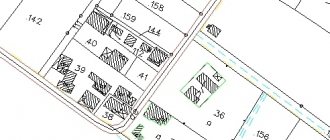
Land plots have established boundaries on cadastral plans. But the fact is that a separate land plot indicated on the cadastral plan may have several owners, and the plot itself in such cases is in common shared ownership.
It should be understood that shared ownership is the concept of ideal property, not real property. That is, each of the co-owners does not own specific land on which they can build a house, equip a greenhouse and erect a fence with a gate, but some abstract figure - 1/2, 1/3, 1/12 and so on.
If desired and, most importantly, if it is possible to allocate a share in kind, the owner can initiate the procedure for allocating shares. This is a big topic that also involves issues of litigation.
However, if the remaining co-owners agree to the division of shares and the cadastral service believes that division of the plot is possible, then the consent of the co-owners will be sufficient to obtain a certificate of ownership of a specific plot of land with established boundaries.
During the negotiation process, the co-owners, with the participation of a cadastral engineer, come to an agreement regarding the establishment of the boundary between their plots. This agreement is secured through the act of agreeing on boundaries.
Subsequently, on the basis of this act, the cadastral engineer will make appropriate changes to the territorial cadastral plans. You can find out more about the procedure for establishing plot boundaries in the corresponding material on our website.
Coordination of land boundaries with neighbors under the new law
The publication and notification contain information about the engineer conducting the process, the date and time, the location of the collection, and the location of land plots with cadastral numbers. If, after the announcement was issued, people did not appear at the meeting, then their signatures are not required. They were notified and did not come, which means they approved the changes.
We recommend reading: Cancellation of deed of gift for a house
A claim is filed to resolve the boundary dispute, accompanied by a written refusal from the defendant to coordinate the boundaries. The main thing is to draw up a claim according to its structure, or the judge may refuse to consider it. It sets out a request to establish the boundaries of land surveying, according to geozodic information.
Procedure
The act of approval may be significantly distant in time from the moment of initiation of the procedure for establishing boundaries.
The fact is that boundaries cannot be established only at the request of land owners. Cadastral authorities play a significant role in the division procedure. They determine the possibility of dividing the site and establishing boundaries.
Once the cadastral engineer determines that there are no obstacles, he begins the preparatory procedure. At least a month before the boundaries are established, he notifies the co-owners of the date for which the final procedure is scheduled.
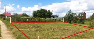
When dividing and establishing the boundaries of a land plot, the cadastral engineer takes all the necessary measurements and sets special boundary markers on which he makes marks about the day they were established.
The entire procedure is reflected in the approval act. In it, the owners record their agreement with the method of establishing and defining the boundaries.
Notification of interested parties
Notification is made in the manner established by Art. 39 Federal Law No. 221.
Read more: Enter the number in the insurance policy after registration
As a general rule, notice must be given one month before the meeting to all neighbors whose plots are located on the border with the land that will be subject to the land survey procedure.
Neighbors are required to be notified if they:
- are the owners of the neighboring land plot;
- have the right of lifelong inheritable ownership of it;
- have the right to use it indefinitely;
In this case, plots provided by municipal or state institutions are not taken into account.
- rent a plot from the state or municipality, and the lease agreement itself is concluded for more than 5 years.
Note! These categories of neighbors can participate in land surveying independently or send in their place representatives acting under a notarized power of attorney.
The law establishes several ways to notify the specified circle of persons:
- by personal delivery of notice;
- transmission of notice by mail (including e-mail);
- publication of a notice in the media at the place of residence (if it is unknown where my neighbors live).
The approximate form of the notification is established by Order of the Ministry of Economic Development No. 735.
The personal or postal notice contains the following information:
- name of the document: “Notice of a meeting to agree on the location of the boundary of the land plot”;
- Full name of the cadastral engineer;
- registration number in the register for the implementation of this activity;
- his SNILS;
- address, email and contact phone number;
- Full name of the notice recipient and address;
- cadastral number of the land plot whose survey will be carried out;
- location;
- Full name or name of the organization - customer of cadastral work, its address, email and telephone;
- address of the meeting and exact time;
- the exact period during which objections to the established boundaries will be accepted (1 month);
- date and time of approval of boundaries at the site of the land plot (at the request of notified persons);
- information about adjacent plots (address, cadastral numbers).
All those present at the meeting must have identification documents and documents confirming the right to the site. If a representative is present instead of a neighbor, he must also have the above documents and a power of attorney.
The notice is signed by the cadastral engineer and sealed.
The notice for publication contains only information about the cadastral engineer, the site being surveyed, the customer of the procedure, the location of the meeting and the date of appeal of the decision.
At the same time, in practice there are situations when the coordination of boundaries is carried out without neighbors.
- The neighbor did not appear at the time and place specified in the notice.
In cases where a notice was sent to a person with an exact indication of the date, place and time, but he did not appear and did not raise any objections to the procedure, land surveying is carried out in his absence with a note to this effect in the act. A copy of the notice must be attached to the draft plan, confirming that the information in it was specified accurately.
- There is no information about the neighbor's location.
To do this, it is necessary to send a notice to the local newspaper and post on the website of the municipal administration about when the boundaries of the site will be agreed upon. If the neighbor does not show himself in any way, the land survey will be carried out without his participation.
- All neighboring areas already have established boundaries.
In the case when all adjacent neighboring areas have undergone the land surveying procedure, and all the necessary documents are available, the participation of neighbors will not be required.
Drawing up an act
As part of this article, we have developed and made available for download a standard sample of acts of the type in question. After a little individualization, the sample will be suitable for use in the procedure for approving the boundaries of a land plot.
In general, the act of coordinating boundaries includes a standard set of sequentially located structural elements, namely:
- Title of the document;
- date and place of drawing up the act;
- cadastral information about the site (sites) between which a boundary is established - area, settlement, other characteristics;
- information about the owners of the plot(s), including the cadastral engineer;
- information about the persons involved in drawing up the act;
- information about markers installed at the boundaries of the site;
- expressing the consent of the owners with the order and method of marking boundaries;
- information about the absence of disagreements between the owners;
- signatures of persons involved in marking boundaries.
If disagreements arise between the owners, their essence will need to be included in the act. In the future, the act with these marks may become one of the materials in a civil case in a claim to challenge the boundaries of a land plot.
An act is drawn up in the number of copies corresponding to the number of parties interested in the act.
Compilation rules
Article 40 in Federal Law No. 221 is devoted to the act of coordinating land boundaries. It says that cadastral engineers are responsible for preparing such a document.
The law establishes a special form for drawing up an act ; it is filled out either on a PC or by hand, but in block letters (blue or black ink).
An act is drawn up according to strict rules:
- Any errors, inaccuracies, corrections or typographical errors are prohibited herein.
- If any data is entered incorrectly, the cadastral engineer must cross it out with a straight line and indicate the current data next to it, putting his own signature. She confirms that the corrections were made by him and not by third parties.
Act on coordination of boundaries with neighbors of a land plot: sample, form download
Many may be interested in why it is said according to the “new law” - this is, of course, a loud statement, but in this way almost all citizens, including employees of government organizations, call it. For this reason, in this case we will talk specifically about the “new law”.
When all neighboring owners have received notification of the planned operation, it is necessary to submit an application to the surveying company where the land plot is located. The application must be submitted to a cadastral specialist who is authorized to provide these services.
How to set the boundaries of a land plot - information for owners and users
The cadastral engineer will study the submitted documents, agree on payment for his work (in parts upon completion or in full before completion), draw up a contract for the implementation of cadastral work (Article 36 of the Law on Cadastral Activities) and inform the date of arrival at the site.
Step No. 2 - Order land surveying
If there are any buildings on the site (house, garage, bathhouse, etc.), then at the request of the customer, the cadastral engineer will determine their location in order to then indicate them in the boundary plan. And it is not necessary to indicate buildings on the site when establishing boundaries (demarcation).
A sample form for a boundary approval act will be offered in the article below. It will help facilitate interaction with land owners. You will need to sign a document with your neighbors, this will serve as proof of agreement with the measurements obtained.
Sample act of removing the boundaries of a land plot in kind
The form contains explanatory examples of filling out individual paragraphs of the document, thereby giving a visual representation of a legally correctly executed document. The act is filled out by a licensed cadastral engineer after technical work has been carried out.
Each self-regulatory organization (SRO) of cadastral engineers approves its own format for the document; it can also be called differently, for example, “ Technical regulations for work on the removal of land boundaries in kind ” or “ Act of transferring the boundaries of a land plot to the area .” Below is a brief description of the most important points of the document.
Contents of the act of removing the boundaries of a land plot in nature
The document includes the following information about the land plot, its owner and the results of technical work:
- cadastral number of the land plot and other information taken from the cadastral passport;
- information about the owner of the land plot, as well as the owners of neighboring plots;
- data on the measuring technique used to measure the boundaries of the site;
- the number and type of boundary markers marked on the site plan as a result of measurements.
The technical report of the cadastral engineer includes several parts: text and graphic, as well as an application; contains:
- initial geodetic data;
- topographical data on the location of the land plot;
- documentary grounds for measuring borders;
- list of the scope of work performed and their description;
- information about the specialists who carried out the work (cadastral engineer and assistants);
- description of the equipment used.
- in the attachment: graphic display on a topographic map of the boundaries and boundary markers of the land plot.
Also interesting: Innovations for summer residents 2020: benefits and fines
In order for a document with the boundaries of land plotted in nature to gain legal force, it is certified by the signature and seal of the cadastral engineer responsible for carrying out geodetic work.