Do-it-yourself geodetic work is easy to do if necessary. Using topography and geodetic analysis, the condition and features of the soil and relief are determined, which influences the choice of the type of foundation. Building blindly can backfire in the first winter.
Without special measurements it is impossible:
Need a master?
- correctly draw up a project for the future home;
- measure the exact height of the building's base;
- describe the measurements and design of the foundation;
- mark the first floor.
After carrying out geodetic work, you can proceed to the next stage. Read our article about building a foundation yourself.
What is the object of measurement?
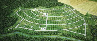
Let's move on directly to geodetic work. To survey a land plot, it is necessary to determine the location of its boundaries. Or its future boundaries. In fact, there are 2 options when taking measurements, regardless of the type of land survey (section, redistribution, clarification, etc.):
1) When a plot of land has certain boundaries, represented by a fence, a wall of a house, or simply pegs. In this case, surveyors determine the coordinates of the turning points of the border for subsequent drawing on the boundary plan. Accordingly, the boundaries will follow the agreed fences, walls or pegs. It is important to understand that if the boundary of the site runs inside a building (usually when dividing a house), then engineers need to know its layout (according to the technical passport) or measure it themselves. This is necessary to delimit the land plot under the house.
2) When on the ground the Customer cannot determine the exact boundaries of the site. This happens for various reasons - the destruction of the fence, or if it never existed at all, and the land was allocated. When dividing a plot - if you need, for example, to divide the plot into several parts in accordance with the shares of the owners. Without accurate measurements, it will not be possible to correctly divide the area. If there are no boundaries, cadastral engineers take measurements of all nearby significant objects (forest boundaries, fences, buildings, etc.), enter all the data into specialized programs and display everything graphically. Next, cadastral information for the work site (KPT) is used and the owner/s of the site are invited. And on the resulting digital plan it will be possible to plot the boundaries of the site. That is, to demarcate in desk conditions, guided by the data of the Customer and the real estate cadastre.
In this case, the land plot will have boundaries, as it were, “virtually”. That is, based on the boundary plan, it will be registered in the cadastral register, but on the ground the boundaries of the site will be unknown. To restore them using cadastral data, it is often necessary to again resort to the services of a cadastral engineer and remove the boundaries of the land plot. This is a separate service that is not included in the land surveying procedure.
Geodetic work during land surveying
In practice, there are often cases when the border runs along the contour of long-term structures located on the ground (buildings and structures, brick, metal or reinforced concrete fences, etc.). In this case, boundary points on the ground are fixed in the form of marks on individual structural elements of these structures with a mandatory subsequent description of their position (for example, along the axis, along the center, along the joint, etc.). To ensure the possibility of restoring permanent boundary signs if they are destroyed or lost, an outline is drawn up for each of them, with clear contours and terrain features (corners of buildings, underground utility wells, power poles, intersections of improved dirt roads, etc.).
Land surveying of land plots is carried out using traditional geodetic methods, which are used in topographic surveying of the area. At the same time, it has a number of specific features and differences that determine its purpose and name. First of all, they relate to the subjects being photographed. For example, a certain terrain element, which is a “physically existing” component of the external environment, serves as an object in topographic survey. At the same time, the completeness and detail of the display of this element on the topographic plan (map) depends on the survey scale. When surveying a land plot, along with such objects, the spatial position of some other objects must also be determined, which must be displayed on the plan of the land plot. Their classification depends on the results of the relevant agreements between the participants in land relations that arise during the surveying of a land plot (for example, the boundaries of restricted zones and encumbrances, real estate objects, etc.). A feature of land surveying is also the need to take external measurements of buildings and structures for their subsequent registration as real estate. At the same time, the accuracy of the measurements does not depend on the scale of the survey of the land plot, which, like the scale of the plan of the land plot, is determined by the task for performing the work.
Land surveying of land plots is usually carried out from the points of the survey network. At the same time, if this is stipulated in the work assignment, then this survey can be carried out by reference to boundary signs securely fixed on the ground. The need to determine, when photographing, the heights of characteristic terrain points on a land plot, as well as in the territories adjacent to it, must be indicated in the work assignment.
Before the start of surveying, the position of restricted and encumbered zones, underground utility routes, etc. must be marked on the ground with poles or pegs. When shooting, it is mandatory to draw an appropriate outline.
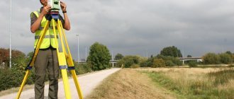
Land surveying of a land plot is usually carried out using an electronic total station. When shooting, the polar method is usually used. It is also possible to use other methods, for example, direct corner cuts, alignment measurements, as well as measurements from the corners of permanent buildings and structures located on the territory of the land plot. In the latter case, at least three characteristic points of the specified buildings and structures must be “attached” to the points of the boundary survey network. To control and eliminate missed “windows” from each survey station, the position of several pickets determined from other stations is established.
When using electronic tacheometers, its operating mode and other information can be recorded by the observer during the shooting process into a removable memory module. The measurement results are recorded in the form of: readings along the horizontal and vertical circles of the tacheometer, inclined distances or their horizontal positions, as well as some other information (service messages), for example: the name of the survey station, orientation point and picket; height of the device at the station and sighting height, object (picket) code.
Table 6.2 shows, as an example, the format and sequence of records in the data file of the 3Ta5 electronic total station.
The entire structure of the 3Ta5 electronic tacheometer data file is divided into seven vertical blocks: 1 - measurement sign; 2 — picket (station) name; 3 — picket (station) code; 4 — distance to the picket, m; 5 - counting along a horizontal circle for shooting
picket (station); 6 — counting in a vertical circle to the survey picket (station); 7 — sighting height (tacheometer height), m.
The information contained in each block is encoded. Thus, block 1 - a measurement sign (see Table 6.2, block 1) can be represented as a sequence of numbers 2012, which is deciphered during processing as follows. This line of the file presents: the measurement results (first digit 2) performed when shooting a picket using the polar method (second digit 0), while the measurement results of vertical angles are presented in the form of zenith distances (third digit 1), expressed in degrees, minutes and seconds (last number 2).
When coding survey pickets, classifier codes are used, usually associated with the corresponding graphic table of symbols (Table 6.3).
If there is a large variety of objects being photographed, picket codes are usually entered into the data file in the process of desk processing of the survey results or at the stage of formation based on the survey results
digital terrain model (by editing the corresponding file).
Previously it was indicated that simultaneously with the survey of the land plot, external measurements of buildings and structures located on the territory of the land plot and which are real estate objects are carried out on a special assignment.
For external measurements, as a rule, 20...30-meter steel tape measures with centimeter divisions, as well as so-called “laser tapes” are used. The latter are small in size, light in weight, durable, and easy to operate. To measure distances, a laser electromagnetic range finder is placed in the tape measure body. During measurements, a laser beam is aimed at the reflective surface of an object to which the distance is measured. Guidance is carried out visually, i.e., along the “laser spot” or using a special optical sight attached to the tape measure body.
To measure lines located in a horizontal plane, the laser tape measure has a built-in cylindrical level, the axis of which must be parallel to the laser beam. As a rule, the working panel of the roulette has a fluorescent backlit screen, which ensures convenient operation in low light conditions.
Laser tape measures, as a rule, have a built-in COM port, which makes it possible to export measurement results to the computer memory both after measurements and in real time.
External measurements of the building must be carried out above the edge of the base at the level of the window openings of the first floor. The edge of the base is the line of transition of the thickened lower part of the walls, called the base, into the wall thickness normal for a given house. This place in the masonry is most often decorated with a shelf or slope. In some cases, when the edge of the base is higher than human height, which prevents measurements from the body of the building, measurements are taken along the base adjusted for the edge, the size of which is specified in the most convenient place for this.
When taking measurements, especially of buildings located on slopes, make sure that the measurements are taken along a horizontal line. Measure the contours of the walls of the building, its extensions, porches, steps, as well as window and door openings along the entire outer perimeter of the building.
If the angles of rotation of the building’s contour are not equal to 90°, then during the measurement, additional constructions and measurements are made that allow not only to correctly display the contour line on the plan, but also to calculate the area of the building.
External projections and pilasters up to 10 cm are not subject to measurement. Protrusions over 10 cm, as well as porch steps, etc., are measured. When measuring wooden buildings, the corners of which are cut “into a cup” with the ends of the logs (plates) protruding, it is necessary to exclude these protrusions from the length and width of the building. When measuring the building externally, an outline is drawn, which is a schematic sketch of the outline of the external walls of the building.
Rice. 1.10. Outline of real estate survey
The outline (Fig. 6. 1), as a rule, is drawn as the building is measured. At the same time, the corresponding dimensions are indicated on the outline, rounding them to whole centimeters. In cases where it is impossible to depict all the parts in the outline and clearly record all the measurements, it is allowed to make a leader on the side of the blank field of the outline, draw the required plan node on a larger scale and put down the necessary measurements.
The starting point of measuring the structure in the outline is marked with zero. The numbers showing the beginning and end of window openings, porches, steps, etc. are written in the outline perpendicular to the drawn wall. Window and door openings, partitions between them, pilasters, columns, ledges, projections and other architectural details are measured from one starting point of the openings on an accrual basis.
For ease of reading tape measurements and recording them in the outline, it is recommended to take external measurements of buildings counterclockwise.
After completing the measurement of the entire building, it is necessary to check the accuracy of the measurement results. For example, control can be achieved by taking random repeated measurements of individual parts of the building envelope. And control of the measurement of a rectangular building can be done by comparing the measured lengths of its opposite sides. Based on the measurement results, the area of the building and (or) its individual parts is calculated.
When dividing a land plot, conditions are usually set regarding the determination of the location of the dividing lines on the ground. At the same time, requirements for the size of the area of individual parts of the divided territory can also be formulated. In this and other cases, land management activities, as a rule, include technical design, one of the stages of which is the so-called “geometric design of land boundaries.”
The basis for geometric design, which is predominantly analytical, can be a technical specification, which includes a preliminary design of the spatial arrangement of newly created land plots, requirements for the direction of individual links of their boundaries, as well as for the size of the area of land plots and their individual parts. When drawing up preliminary designs, they rely on the requirements of land legislation, as well as on information from the state land cadastre about the territory being transformed, stored in the form of: duty cadastral maps, plans of land boundaries and cadastral plans of land plots, catalogs of coordinates of turning points of land plot boundaries, etc.
The necessary initial data is also obtained in the process of surveying a land plot or by appropriate measurements using topographic maps and plans. When choosing a specific method for obtaining initial data and design methods, one should proceed from the requirements for the accuracy of determining the position of the boundary points of land plots established by the current regulatory documents.
The essence of the analytical design of land plot boundaries is to determine digital data that, with a given accuracy, geometrically correspond to the preliminary design of the spatial location of the design object. Subsequently, taking into account these data, a project for outlining (alignment drawing) the newly formed boundaries of land plots is drawn up. Depending on the given geometric conditions for designing the boundaries of land plots, the most frequently encountered problems in practice can be divided into two groups. The first group of problems includes those in which one of the design conditions requires that the area of the newly formed site or part of it be equal to a given value. In the future, we will call such tasks “Design of land plots of a given area.”
How is the site location determined?
Let's look at the most common method, which is followed by 90% of cadastral engineers.
First of all, it is necessary to determine the coordinates of the survey points of the tacheometric traverse (i.e., the points on which the device stands). How to do it? To lay out and equalize the course, you need at least 2 points with known coordinates (it is more correct to use at least 3 points to eliminate errors). There are 2 types of items:
1) Points of the state geodetic network (GGS). These can be wall, ground benchmarks, geodetic pyramids, etc. There are quite a lot of such points in Moscow and they are constantly updated. In the Moscow region and beyond, the situation is much worse. The density of points reaches 1 per several square kilometers.
2) In case of inconvenient location or shortage of GGS points, GPS coordination is used. Read more here. That is, they determine the location of the starting points (this could be a fence pipe, a concrete dowel, reinforcement, etc.) - a temporary geodetic support.
A polygonometric path is laid between the control points, measuring at the station the angles and distances to the points and between the tripods. At the same time, they coordinate boundary signs and other terrain objects (if necessary). After field work, the measurements are adjusted using specialized programs and the coordinates of all measured objects, including the boundaries of the site, are determined.
Now, knowing how geodetic work is carried out during land surveying, you will have a clearer idea of what cadastral engineers will do on your land plot.
Prices of our services
Why do you need a topographic survey of a site?
Before making a site plan, a topographic survey is carried out. This is an extremely important procedure. Moreover, it is required not only formally, during land cadastral registration, and not only for large construction companies. It is vitally necessary, for example, for the owner of any, even the smallest plot of land. After all, only accurate marking of the boundaries of your property and a plan for underground communications will ensure that you avoid conflict situations with neighbors or various public utilities in the future.
Topographic survey is carried out in the following cases:
- connection to the electrical network, gas pipeline, water supply and heating network, telephone cable, heating network, sewerage;
- when redeveloping the above communications;
- upon obtaining permission to build a house;
- purchasing a plot of land for ownership or lease;
And when performing activities such as:
- Design work for the reconstruction and construction of buildings;
- Linking the construction site to the area;
- Calculation of the volume of excavation work (for example, when digging pits);
- Landscape design;
Let's consider specific situations when topographic surveys are indispensable.
Who conducts geodesy
If you need to carry out geodesy of a site in Moscow, you must contact a company specializing in such services. High-level specialists with many years of experience will conduct research and provide all the necessary information, plans, maps, technical projects legally. Professionally carried out geodetic work on the site contributes to the trouble-free connection of the structure to technical networks, the creation of unrivaled landscape design, construction strictly according to the established project, and as a result, a reduction in the cost of construction work. Specialists will quickly and efficiently carry out all research and provide a complete package of documents.
Geodesy is a very important event, because future construction, its reliability and durability depend on the quality of its implementation. It also influences the development of the territory, as it provides the best options for the construction of buildings for any purpose. With the help of geodetic research, you can determine the most advantageous option for creating a landscape.
Stages of work
One of the components of the success achieved by our company is the clear organization of the survey work by dividing it into several successive stages:
- Stage 1. On the day of receipt of the technical assignment for surveys on the geodesy of the site, our company’s specialists begin to study archival topographic and geodetic materials on the territory on which your site is located. Thanks to our extensive archive of geodetic data on the territory of Moscow and the Moscow region, within the first 24 hours we are already able to prepare a detailed survey program and determine the main reference points, based on which we can carry out geodetic measurements. At the same time, our other employees are preparing an agreement and registering surveys with the local government authority of the area where geodesy of the land plot will be carried out.
- Stage 2. Field geodetic measurements. At this stage, our company’s visiting teams of surveyors carry out the necessary elevation and plan measurements on the ground, using appropriate geodetic instruments and tools. The horizontal coordinates and absolute heights of terrain points, structural elements of existing buildings and structures are determined; lines of underground engineering networks and utilities are identified. For large construction projects and on land plots with difficult conditions for geodetic work (dense buildings, large differences in elevation of landforms), preliminary reconnaissance on the ground may be required. We carry it out in order to clarify the necessary methods and techniques of geodetic work that will allow you to quickly and inexpensively complete your order.
- Stage 3. Office work, as well as coordination of prepared cartographic materials:
- boundary plan;
- topographic plan;
- plans and drawings of as-built survey;
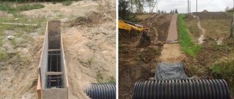
- diagrams of underground pipelines, cable lines; —
and a technical report on the geodesy of the site. The technical report includes factual material collected during the survey: statements, catalogs of point coordinates and other special geodetic information. At the desk stage, we use modern software for processing geodetic data. Schemes of underground communications are coordinated with the enterprises responsible for their operation. The necessary approvals of the plan with government organizations are also carried out. Customers receive from us fully prepared and approved documents.
To create a house project and improve the site
Well, in addition to everything, any conscientious designer will definitely request a topographic plan of the site: both a builder and a designer. After all, a topographer-surveyor creates not just paper, but a real model of the area. Only using this model can you correctly calculate where and how best to place buildings in order to effectively use the existing relief, and how much soil will need to be selected for the foundation pit, as well as create a landscape design. For landscapers, ordinary topographic plans are not suitable; they need more detailed topographic plans.
Is site surveying always necessary?
Definitely yes! The services of surveyors will definitely be required, both for the legal registration of rights and registration documents for a land plot, and for the opportunity to begin capital construction on it. And, technically, it is not possible to carry out design, as well as carry out a construction complex of works, without geodetic surveys. The developer will need engineering and geodetic documents at every stage of the planned construction, from the preparation of materials for the State Land Cadastre and up to the commissioning of the constructed facility. The standard set of studies on the geodesy of a land plot for construction, which our specialists do, consists of:
- drawing up a boundary plan and setting out the boundaries of the site;
- drawing up a situational plan;
- carrying out topographic and geodetic surveys to produce a geobase for design schemes and drawings;
- layout of the project on the ground (marking the contours and axes of the designed structures at the construction site);
- executive geodetic survey of the site with all constructed objects after completion of construction work.