Having made a survey, disputes arise about the boundaries, since often the results do not coincide with the data of the cadastral passport (it turned out to be smaller or larger). What to do if, during land surveying, the area has increased/decreased? In the article we will consider this issue, and also find out whether it is possible to change the boundaries after land surveying, how to legally increase/decrease, and correctly register the increase/decrease of the site. Then we will study how land ownership increases through “cuts”? The actual area and boundaries of land plots do not always correspond to the data specified in the cadastral passport of the property. It happens that a land user has conscientiously owned extra acres for several decades. However, the mere fact of bona fide ownership of a land plot is not enough to formalize your rights. What happens in such situations when the land plot is actually larger than according to the documents? Read on.
The procedure for increasing land ownership by registering “additions”
After land surveying, the site became larger. How should I design it? Another special case when the boundaries of an allotment can increase after land surveying is the design of “additions” that are actually already in use or that the owner just wants to add to his land.
The right to increase their territory in this way for owners of dachas, private houses, garden plots, vegetable gardens and subsidiary plots is provided for in clause 3, part 1, art. ZK RF.
This is possible if such a territory is bordered by state or municipal lands that are not classified as public lands and have not been withdrawn from circulation.
The procedure for making a cut is as follows:
- the landowner applies to the authorized body with an application for the redistribution of plots in private and public ownership;
- the authority sends him consent to such redistribution if there are no grounds for refusal (the land has not been withdrawn from circulation, not provided to another person, etc. - a total of 13 grounds for refusal);
- the applicant hires a cadastral engineer to record the resulting lands and registers them in the Unified State Register of Real Estate;
- a redistribution agreement is signed, which specifies the fee for which the lands are transferred from public to private ownership.
Applications for redistribution of land plots.
ATTENTION! The plot obtained as a result of registration of an “addition” should not be larger than the established maximum size for landholdings of this type.
You will learn how to cut land to a site from the video:
Failures due to excess area
These are cadastral works that are carried out by a specialist - a cadastral engineer, and data on which are included in the Unified State Register of Real Estate. IMPORTANT! For the owner, the land survey means that restrictions on disposal are lifted from his land. That is, he can start building a house and make any transactions with land:
- sell;
- present;
- pass on by inheritance.
What to do after land surveying? Upon completion of the preparation of the boundary plan, you need to register the result of clarifying the location of land ownership boundaries in Rosreestr - submit documents for making changes to the Unified State Register of Real Estate. This can be done by the owner or the cadastral engineer himself. Reasons for changing boundaries Completion of cadastral work means that the boundaries of the site have been clarified and it has been finally determined as an object of civil law.
Documenting
When changing the boundaries of a site, in addition to the standard steps for registration, that is, drawing up a survey act and a boundary plan, registration in the Cadastral Chamber and registration with Rosreestr, you also need to contact the local administration. It will be mandatory to obtain permission to change the boundaries of the site in the area controlled by the municipality - without this, further steps to formalize it will not be possible.
We invite you to familiarize yourself with: Sample will for an apartment 2019
Reasons for changing boundaries
Completion of cadastral work means that the boundaries of the site have been clarified and it has been finally determined as an object of civil law.
How to increase the area of land after land surveying? It is impossible to arbitrarily change the boundaries after completion of the procedure - this requires a strong legal basis: an agreement, a court decision or recognition of a cadastral error.
Often, after the completion of land surveying, landowners are faced with the question: is it possible to change the boundaries of the land plot after surveying, and annex neighboring empty lands to their plot in order to smooth out the unevenness of its borders, expand the area in front of the house, or equip a parking space?
The legal grounds for increasing the site after land surveying can be:
- registration of “addition” through the redistribution of land provided for in Art. Land Code;
- correction of an error made by a cadastral engineer;
- acquisition of a neighboring plot of land as a property (as a result of donation, purchase, inheritance) and merging it with the existing one.
How to change the boundaries of a land plot after land surveying?
A reduction in land ownership is possible if the court recognizes the rights of a neighbor to a part of the plot that was determined to be controversial in the act of reconciling boundaries. It can also occur due to the recognition of a mistake and as a result of the division of the plot for the subsequent alienation of part.
If during geodetic work the area of the site has changed
Land surveying is a geodetic procedure by which the boundaries of a land plot are clarified using geodetic equipment.
Read more about what land surveying is. Next, a boundary plan is drawn up, the boundaries are agreed upon with the owners of neighboring plots of land, and the whole process is completed by the subsequent registration of updated information about the site in Rosreestr.
The legal basis for this is the following norms of the Land Code of the Russian Federation:
- Article 39.28. It spells out the grounds and restrictions for increasing the area of land.
- Article 11.9 defines the requirements for plots of land whose area changes as a result of land surveying.
- Article 39.29. contains rules on the procedure for concluding an agreement with representatives of local authorities to increase the area by moving boundaries.
When the surveying procedure is completed, this means that the boundaries of the site have been verified (read about how the boundaries of the site are established), and information can be submitted for registration in the cadastre or making changes to already recorded data.
But it is impossible to change the boundaries on your own without compelling reasons, such as a contract (sale and purchase, for example), a court decision that has entered into legal force, or recognition of erroneous information in the cadastre.
Let's take a closer look at special cases of increasing or decreasing plots of land during land surveying and figure out how to act correctly in a given situation.
Justification for reducing the area of the land plot
When clarifying the location of the boundaries of land plots located within the boundaries of the territory of a horticultural, gardening or dacha non-profit association of citizens, the location of the boundaries of these land plots is determined in accordance with the territory surveying project approved in the manner established by the legislation on urban planning or the project for organizing and developing the territory of such an association of citizens or another document establishing the distribution of land plots in such an association of citizens. 3. When clarifying the location of the boundaries of the land plot defined in paragraph 1 of part 1 of Article 42.1 of this Federal Law, its area determined taking into account the requirements established in accordance with the Federal Law of July 13, 2020 N 218-FZ “On State Registration of Real Estate”, should not be: (ed.
Legal increase in land area
Also, this process can be carried out at the initiative of the bodies authorized to regulate cadastral issues for the following purposes:
- bringing the boundaries of the land plot in accordance with the approved land surveying project;
- placement of capital construction projects, as well as withdrawal of plots for state or municipal needs.
The diagonal method, as an additional clarification, is used in boundary work when high measurement accuracy is required, for example, in the lands of urban settlements when determining the boundaries of lands related to apartment buildings.
LLC “Srednevolzhskaya Land Management”) Samara, st. Antonova-Ovseenko, 44B
The costs of cadastral specialists in this case are subject to recovery from employees of the state cadastre in court.
If the state real estate cadastre contains information about the boundaries of the original land plot, then their preliminary (not in connection with the actual formation of land plots from it) clarification is not required.
As a result of cadastral work, the area of the site was 1039 sq.m. Is it possible to register ownership of such an area (1039 sq.m.)? In my opinion, no, since according to the actual occupied area it was possible to register in the order of the so-called.
Legislative norms reflect possible situations when the representative office of the State Real Estate Cadastre may refuse to register a territory for cadastral registration.
The most significant characteristics of any land plot, which are defined as unique and allow one to unambiguously identify this plot as a real estate property, are the location of the boundaries and the area.
Coordination of the boundaries of a land plot with adjacent land users - from 1 week to 1 month. 7. Support of the procedure for making changes to information about a land plot in the state real estate cadastre - 1 month.
It is necessary to strictly ensure that there are no violations of the rights and freedoms of owners of other plots.
Important! The annexed plot must not exceed the established minimum size established by land use regulations. Municipalities determine the area independently. But if there is no such regulatory act, then the annexed plot cannot exceed the area of the main one by more than 10 percent - the law in this regard is quite clear and does not allow errors.
By observing all the stated criteria, you can achieve the goal of increasing the area of the land plot while clarifying the boundaries and achieve the inclusion of data about this in the State Property Committee.
Important! The annexed plot must not exceed the established minimum size established by land use regulations. Municipalities determine the area independently. But if there is no such regulatory act, then the annexed plot cannot exceed the area of the main one by more than 10 percent - the law in this regard is quite clear and does not allow errors.
What to do after land surveying? Upon completion of the preparation of the boundary plan, you need to register the result of clarifying the location of land ownership boundaries in Rosreestr - submit documents for making changes to the Unified State Register of Real Estate. This can be done by the owner or the cadastral engineer himself.
The specified area of the land plot should not be greater than the area about which information regarding this land plot is contained in the State Property Code, by an amount more than the maximum minimum size of the land plot (determined by regulatory acts of government bodies), or, if such a size is not established, by an amount more than 10% of the area according to the document (Part 1, Clause 5, Article 27 of the Cadastre Law).
Regarding the division of a land plot, in which the original land plot is not preserved within the changed boundaries or can be preserved within the changed boundaries, but the customer of the cadastral work made a decision to clarify its boundaries simultaneously with its transformation, and the sum of the areas of the formed land plots differs from the area of the original land plot, Let's celebrate.
S. having considered in open court K.’s appeal against the decision of the S. Posad City Court in a civil case on the claim of SNT “Ivashkovo-2” to K. regarding invalidation of the results of land surveying, invalidation and exclusion of information from the State Property Committee, making changes to the registration record in the Unified State Register, having heard the report of judge Ivanova T.I.
Features of clarifying the location of land boundaries when performing complex cadastral works ConsultantPlus: note. From September 16, 2019, Part 1, Art. 42.8 is stated in a new edition (Federal Law dated June 17, 2019 N 150-FZ).
When surveying the land plot, the area increased
An increase in land allotment due to the elimination of an error occurs if the cadastral engineer, when preparing the boundary plan, incorrectly indicated the boundaries of the land.
There are two ways to detect an error:
- by looking at your plot on the public cadastral map;
- having ordered the removal of boundaries in kind from a geodetic company.
If during land surveying the area turns out to be larger and an error is discovered, then a new land survey is required - preparation of a land survey plan to correct the cadastral error. If the situation is favorable, the case will be resolved pre-trial by agreeing on a new location with the neighbors.
If you cannot reach an agreement peacefully, you will have to go to court. Based on the court decision, the cadastral engineer prepares a new boundary plan.
How to challenge the boundaries of a land plot after surveying, watch the video:
Legal area of the plot?
It depends on the purpose and purpose of use of the territory. Determining the minimum and maximum sizes of land plots lies within the competence of local legislators.
And if the square footage of the specified territory exceeds the maximum dimensions adopted in the subject, then the local cadastre authority has the right to refuse registration of the plot.
It should be clarified that the 10% limit is limited only to those regions or categories of land for which local authorities have not established maximum values.
True, practice shows that even when a maximum size is established, the cadastre service pays little attention to this indicator. And if the excess size is more than 10 percent, then refusal immediately follows. If you go to court, such a refusal is usually declared illegal.
Reducing the area of land.
Info If there are no documents, the boundaries of the land plot are recognized as boundaries that have been in effect on the area for more than fifteen years and are fixed by natural or artificially created objects. Clarification of the location of the boundaries of a plot registered in the cadastral register is carried out in certain cases:
- at the time of acquisition of ownership of a previously registered plot of land;
- in disputes with neighboring owners;
- before selling the plot;
- in case of errors in cadastral documentation;
- before dividing the site into several plots;
- for documenting cuttings.
Boundary clarification is carried out by a cadastral specialist from the federal register of cadastral officials, or by a geodetic company that holds a license to conduct land surveying.
Reducing storage area: how to register?
The need to reduce the area of land may arise in the following cases:
- if the court has recognized the neighbors’ application for disagreement with the boundaries of the site as lawful (the neighbor noted his disagreement in the approval act),
- if a cadastral engineer’s mistake is recognized
- if the plot is subject to division and alienation of part of the land.
Having resolved a dispute with neighbors peacefully, it is enough to sign an act of coordination of borders. Changes to the Unified State Register will be made on the basis of the act.
If an error made by a cadastral engineer is discovered, the survey should be repeated. The basis for adjusting the USRN data will be a new boundary plan.
How to justify reducing the area of a land plot
Articles by our lawyers Question of the day on the topic: Lists of houses for demolition 2016: Home Lawyer online Land law Reducing the area when surveying a land plot Nikolay, Noginsk City, Moscow region, at 01:09 During registration, 4 acres were cut. On what basis or law did they do this? A little background.
My grandfather had a plot of 30 acres. During the measurement, everything went well, as it should all 30. A surveyor from their land surveyor. When submitting documents and further operations during registration, it turns out that 4 acres go to the left.
There are no explanations. Please help. Thank you in advance. Is it possible to cancel the registration and do it again, with the return of my 30 acres, which were also given to my grandfather for farming? Answered by: lawyer, Egorov Konstantin Mikhailovich, Moscow Book a consultation by phone. — 8 (495) 740-55-17 Hello. There can be many explanations for this circumstance. Consequences of the absence of an established border If the extract from the Unified State Register contains a record that the border of a plot of land has not been established in accordance with the requirements of land legislation, you should think about it. This applies to the potential owner and the upcoming land purchase transaction. Important The buyer must understand that the absence of established boundaries of the site does not guarantee compliance with the rights of the owner regarding the passage of the boundaries of the site. This often leads to disputes that escalate into litigation. If the buyer purchases a plot of land without established boundaries, he will have to establish them at his own expense. The legislation establishes that from January 1, 2020, when concluding any administrative transactions, the presence of fixed boundaries will be mandatory. It will be impossible to sell, donate, rent out or inherit a plot of land without a land surveying procedure.
What difficulties may arise?
When transferring extra acres to yourself, you should not forget about two nuances that may interfere with the procedure for registering extra acres.
So, firstly, it is possible to increase the area of land owned free of charge only if one condition is met - the land plot being registered must not exceed the minimum minimum amount of land when allocated.
As Part 5 of Article 27 of Federal Law No. 221 indicates, “the additional part should not exceed the maximum minimum plot size established ... for lands of the corresponding intended purpose.”
An example of the interpretation of this norm!
For example, in many regions of the country, plots for summer cottage construction are allocated with a size of 6 acres. This standard area is also minimal. Consequently, based on the letter of the law, the owner of the land in dacha construction does not have the right to add more than 6 acres to his property.
Or for individual housing construction, the allocated minimum is 2-3 acres, depending on the location of the land. This means that the owners of land allocated for individual housing construction cannot add more than 2-3 acres, which are actually in their possession.
The determination of the indicated minimum land plots during allocation is within the competence of regional legislators and local governments. A direct reference to this norm is contained in Article 33 of the Land Code of the Russian Federation. However, not all regions establish minimum land allocations. In such cases, the Law “On the State Real Estate Cadastre” indicates that the permissible maximum of land added free of charge will be equal to 10% of the land area indicated in the cadastral passport.
Secondly, the cadastral engineer, when drawing up a boundary plan, must provide a justification for increasing the area. This is indicated in the Law “On the State Real Estate Cadastre”.
Article 38 Federal Law 221:
“When clarifying the boundaries of a plot, their location is determined based on the information contained in the document confirming the right to the land plot, or in the absence of such a document, from the information contained in the documents that determined the location of the boundaries of the land plot when it was formed. If the specified... documents are missing, the boundaries of the land plot are the boundaries that have existed on the ground for fifteen years or more and are fixed using natural objects or objects of artificial origin that make it possible to determine the location of the boundaries of the land plot.”
Clarifying the location of the boundaries of the land plot: procedure
28 of the Cadastre Law establishes that a cadastral error in the information of the state real estate cadastre is subject to correction in the manner established to take into account changes in the relevant property (if the documents that contain such an error and on the basis of which information is entered into the state real estate cadastre are documents submitted to in accordance with Article 22 of the Cadastre Law), or in the order of information interaction (if the documents that contain such an error and on the basis of which information was entered into the state real estate cadastre are documents received by the cadastral registration authority in the order of information interaction) or on the basis a court decision to correct such an error that has entered into legal force. In accordance with Part. Otherwise, the cadastral registration authority (cadastral chamber) will decide to refuse to carry out this cadastral registration (subparagraph 1 of paragraph 5 of Article 27 of the Federal Law “On the State Real Estate Cadastre”).
We invite you to read: Apartment to pay off alimony debt
In accordance with paragraph 1 of Article 4 of the Federal Law of July 24, 2002 No. 101-FZ
the minimum sizes of new land plots formed from agricultural lands can be established by the laws of the constituent entities of the Russian Federation in accordance with the requirements of land legislation. Added: 04/16/2011 08:32 But in any case, the absolute discrepancy between the calculated and documented area should not exceed the permissible error. No, of course!
The permissible error of the memory area is a simple function of the error of the determinations of the character coordinates you performed today. points Mt and nothing more.
You measure very precisely - down to millimeters, delta P will be very small.
It should be taken into account that previously the law did not require the need to carry out boundary work and establish the boundaries of land plots (with coordinates) before making them the property of citizens and organizations.
- For making cuts.
- Before dividing the land into several separate plots;
- If disputes arise with neighboring land users;
- When acquiring ownership of a previously registered land plot;
- Before sale;
- If there are errors in cadastral documents;
- Conclude a contract to clarify boundaries;
- Register the prepared boundary plan with the cadastral chamber.
- Coordinate with neighboring land users the land surveying project prepared by the cadastral worker based on the measurement results;
- Choose a surveying company;
- Provide company employees (cadastral engineers) with access to the site to conduct topographic surveys;
Should they have a decision on the allocation of land, and not just the signature of the head of the administration on approval? Who will be the defendant in court? Hello Maria. the increase in area due to clarification of boundaries cannot exceed 10% of the area allocated to the property. In your case, we are not talking about increasing the land plot, but about providing a different plot compared to the one already in use.
Clarifying the boundaries and area of a land plot is a very complex procedure, which includes: mandatory geodetic work to determine the boundaries of the site, the formation of a boundary plan and coordination of boundaries with adjacent land users.
The need to carry out cadastral work to clarify boundaries is primarily due to the fact that a significant part of the information about land plots throughout the Russian Federation is entered into the real estate cadastre declaratively (according to data from the original title documents without establishing boundaries on the ground).
When clarifying the boundaries, the area of the previously recorded site may be increased or decreased by 10% of the original area specified in the title or title document.
In addition, from 2020, land owners who have not undergone the survey procedure and whose boundaries are not included in the Rosreestr database will not be able to fully dispose of them. The owner of the plot will not be able to sell, donate, or inherit it.
In order to dispose of his plot, the owner will have to carry out land surveying.
Clarification of land in Nizhny Novgorod, as in other regions, is subject to certain established rules.
Initially, all materials available on your land are studied. During this analysis, it becomes clear what volume and type of work needs to be carried out.
When clarifying the boundaries of a land plot, parts of the boundaries of adjacent (neighboring) boundaries are usually clarified. In this case, you need to warn your neighbors in advance that geodetic measurements will be taken.
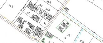
The easiest way to understand whether it is necessary to clarify the boundaries and area of a land plot is to look at the “Public Cadastral Map” for information about the boundaries of the land plot, and also look at the Cadastral Extract or Cadastral Passport.
If the border is not established, this will be reflected in paragraph 16. of this document.
- it is not possible to register the right to an unidentified land plot, which means it cannot be sold, bought, mortgaged or inherited;
- until the boundaries are agreed upon (clarified), there is always the possibility of squatting;
- there are no clear guidelines for the construction of new facilities;
- in some cases it is possible to increase the area;
There is one more point: sometimes the owners do not even know that there is no information about their plots in the cadastre. The fact is that previously land surveying was carried out in the so-called “local coordinate system” and not all areas were transferred to the new system.
In order to find out whether land surveying was carried out before, you need to contact the cadastral chamber with an application for the provision of an old land survey file (up to 2008 inclusive). If such a thing exists, then you need to recalculate the coordinates.
Clarification of the boundaries of the site with an increase in the area of the latter is carried out if it is necessary to formalize additions from the number of public lands. This applies to cases when land users arbitrarily move the actual boundaries of the site (fence or fencing) towards increasing the area of the site at the expense of public public lands (roads, clearings, etc.).
You can increase the area of your plot of land by adding such extensions by no more than one tenth of the measured units (square meters) from the original values, and the plot with updated boundaries should not approach the red lines of the territory closer than one meter.
Next, you can read the part of the law “On the State Real Estate Cadastre”: 9.
When clarifying the boundaries of the land, their location is determined based on the information contained in the document confirming the right to the land plot, or in the absence of such a document, from the information contained in the documents that determined the location of the boundaries of the land plot when it was formed.
Clarification and change of location of boundaries and area of the site
Attention Statement of Claim and Attached Documents Before applying to the district court to clarify the boundaries of a plot of land, the applicant must familiarize himself with the legally correct form of the statement of claim. When filling out, you must adhere to the following rules:
- Heading of the statement of claim - indicates the judicial body to which the petition is sent, contacts of the plaintiff or his representative, and the defendant. When paying the state fee, its amount is indicated.
- The title of the document, “Statement of Claim to Establish the Boundaries of a Land Plot,” is located in the middle and there is no period at the end of the sentence.
- Contents - information about the land plot owned by the plaintiff, its exact address, numbering according to the cadastre, information about the carrying out of boundary work are indicated.
What lands are not subject to privatization?
When re-registering “additional acres” in your name, you should take into account the legal nature of these lands. Is it possible to obtain private ownership of this plot of land? This is the question every land user should ask when registering their rights to the “extra acres.” The Land Code contains a rule limiting the turnover of a certain category of land.
Thus, the following plots are not subject to transfer of ownership:
- within specially protected natural areas;
- from the forest fund lands;
- within which water bodies that are in state or municipal ownership are located;
- provided for the needs of transport and communications organizations;
- located within the boundaries of lands reserved for state or municipal needs;
- located in the first and second zones of sanitary protection zones of water bodies used for drinking and domestic water supply.
The Water Code of the Russian Federation also contains a rule banning privatization. Thus, it is prohibited to privatize lands within the coastal strip where there are flooded quarries and ponds.
There are often cases when lands from the forest fund are adjacent to dacha plots. Taking advantage of the situation, citizens are taking over forest lands. Despite this, the Forest Code prohibits the registration of ownership of such lands. In this case, the length of time the land is in the use of the summer resident does not matter. It should be borne in mind that Article 71 of the Forest Code of the Russian Federation allows for the provision of land from the forest fund for free use for a certain period and for lease .
How much land can you add?
In practice, there are often cases when the data on the area and boundaries of a land plot in title documents are not identical to the actual state of affairs. There are many reasons for this. Most often, the discrepancy between the data in the cadastral passport and the actual boundaries of the land was the result of improper measurement of the land. Experts say that land surveying previously took place without reliable tools, which results in a significant error in the area of land on paper and in fact .
In addition, there are often cases when owners of dacha plots willfully change the boundaries of their lands, moving fences and partitions on their plots. So, a situation arises when a person owns 6 acres according to documents, but the actual area of the property is 7-8 acres. How can the owner act in such a situation? How to obtain documents for additional plots of land?
Only if data on the boundaries of the land is not entered into the state real estate cadastre, then the land user has the right to register ownership of the “extra” acres free of charge.
The reason for the lack of accurate data about the land is most often the lack of land surveying procedures.
Only on the basis of land surveying can all data on the location and area of a land plot be legally obtained. Several categories of owners of summer cottages can re-register “extra” acres. First of all, these are landowners or their heirs who received real estate during the Soviet Union. Also, certain problems and difficulties in law enforcement practice existed before the adoption of the Land Code of the Russian Federation. It turns out that persons who acquired land before October 30, 2001, before the entry into force of a single codified act in the field of land legislation, will most likely re-register additional parts of the land without any problems.
What is the mechanism for “adding land”? A cadastral engineer or surveyor draws up a boundary plan. The area and location of the boundaries of the land plot are established and documented. At his place of residence, the owner with a land survey must contact the cadastral chamber. When filling out an application to change the cadastral passport of an object, it would not hurt to indicate the legal basis, referring to the Law “On the State Real Estate Cadastre”, namely Article 45 part 7.
Who makes the final decision on clarifying boundaries?
Based on the results of the cadastral engineer’s work to bring the actual and normative boundaries and area of the site into compliance, the cadastral registration authority (Rosreestr) makes a decision:
- On amendments to cadastral registration information in terms of clarifying the area of a plot of land;
- On the refusal to carry out cadastral registration in terms of clarifying the area of a plot of land.
The decision to refuse to make changes to the cadastral registration information is made in cases where, as a result of this registration, the area of the plot, determined taking into account the requirements of the law, will be greater than the area, information about which is contained in the Civil Code, by an amount greater than the maximum minimum plot size established for land the corresponding intended purpose and permitted use, or, if such a size is not established, by an amount of more than 10% (ten percent) of the area, information about which is contained in the State Property Code.