Causes of land survey violations
Quite often you can see the situation: neighbors argue about the location of the fence dividing land plots. It is from property claims that the dispute stems from violations during land surveying. And violations, in turn, may be associated with incorrect indication of coordinates, false information about sites, careless execution of documentation, and ignoring objections, including those made in writing. But regardless of the nature of the violations, both the survey customers and their neighbors suffer.
Why is a cadastral engineer (CI) wrong? There are actually many reasons, but the most common ones can be identified:
- inexperience of the cadastral engineer or his low qualifications;
- malfunction of surveying and other equipment;
- imposition of additional services;
- a criminal conspiracy between the customer of delimitation and the cadastral engineer for the purpose of illegally allocating territories that are the property of third parties.
But if a violation is detected, the survey customer has the right to take any legal means to protect his rights and interests.
Why do disputes with neighbors arise?
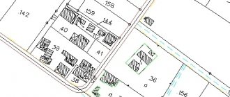
Boundaries are the main individualizing attribute of a site, and they are established by cadastral engineers during the relevant work.
And since such land is usually adjacent to neighboring plots, not all landowners may be satisfied with the division being carried out. This is why disputes with neighbors are so frequent when surveying a plot of land. It may happen that when determining the boundaries, it will be discovered that they overlap or intersect with the boundaries of adjacent areas, and data about the latter is already in the Unified State Register of Real Estate. There may be other reasons.
To find out whether the boundaries of your plot are defined, order an extract from the unified state register of real estate - everything will be indicated there if the plot was previously registered.
Complaint about the actions of an engineer
A lawyer on land issues points out: The cadastral engineer is responsible for his research. If you find shortcomings in the work of a specialist, you can file a complaint.
The addressee is a self-regulatory organization, the prosecutor's office and even the court. The body that will consider the appeal should be selected based on the nature of the violations and consequences.
- minor violations are dealt with by the SRO;
- violations in connection with which property damage was caused - the prosecutor's office or the court.
The complaint can also be used if land surveying was carried out without the owner. Read about how the boundaries of a site are clarified without title documents here.
Ivan Sh. turned to a cadastral engineer to annex the ownerless territory to the site. But the land unexpectedly went to the neighbor. The man turned to a lawyer for help. The specialist drew up a written complaint to the cadastral engineer demanding a refund for services not provided. The engineer ignored the complaint, the lawyer sent a complaint to the SRO. Based on the results of consideration of the complaint, Ivan received back the previously paid money.
When resolving the issue of land surveying with the help of a complaint, it must list exactly what violations were committed during the provision of the service. Also indicated:
- Full name, address, contact telephone number of the applicant;
- Full name and contact details of the cadastral engineer;
- cadastral number and address of the site in relation to which the work was carried out, as well as information about the neighboring site, if the dispute is about a common border;
- specific requirements - return money for poor-quality service provided, eliminate shortcomings, etc.
If documents are attached to the complaint, an inventory of all attachments must be made. Despite the fact that it is possible to draw up the document yourself, it is better to ask for the help of a lawyer. In most cases, the SRO formally approaches the consideration of independently written requests from dissatisfied CI clients. Therefore, the participation of a lawyer will have a positive impact on the outcome and will allow you to avoid unnecessary nerves and going to court.
Changing the boundaries of the site
Let's look at a common reason for a dispute between neighbors. The owner carried out land surveying and registered the plot in the Unified State Register of Real Estate. When his neighbor began to carry out the same procedure to clarify his boundaries, he discovered that the boundaries of his land plots had overlapped and he was denied registration.
This situation could occur due to the fact that:
- the boundary reference point from which the measurement was taken was incorrectly selected;
- land surveying was carried out along the existing fence between neighbors, which was installed incorrectly;
- the documents for the land did not contain data on the coordinates of the borders.
There are two ways to carry out land surveying correctly and resolve disputes between neighbors in the area: administrative and judicial. In the first option, the neighbors come to an agreement, the cadastral engineer makes the necessary adjustments, and the area of the adjacent plot does not change. After this, a plan for coordinating boundaries is drawn up.
But such peaceful settlements are rare rather than the rule. Nobody wants to reduce the area of their land plots. Therefore, you have to go to court.
Registry errors often lead to a situation where, in accordance with the new boundary plan, the border runs along the neighbor’s property for several meters and the fence needs to be moved. If we are talking about a minor change in boundaries, then the dispute can be resolved by reaching an agreement with the neighbor. If the area of the plot changes significantly, then you will most likely have to go to court.
The statement of claim must contain the requirement:
- on determining the boundaries of the land;
- on correcting erroneous data entered by cadastral engineers and making changes to the Unified State Register of Real Estate;
- recognition of land rights.
The coordinates of the formed plot are also indicated based on the engineer’s conclusion.
The boundaries of a land plot are the lines defining the location of the land plot.
Conventionally, they can be divided into the following types:
- actual (how the borders are at the moment, taking into account fences, ravines, and other artificial obstacles);
- decorative (how the site is located from the point of view of the state and before cadastral work);
- historical (how the borders were originally located);
- legal (borders taking into account cadastral work, but before cadastral registration);
- boundaries that are included in cadastral registration
Land survey disputes
A dispute between neighbors arises when determining the legality of the lines dividing these areas. In amicable dispute resolution, the owners come to a consensus after studying the issue.
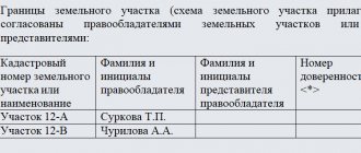
Notification of land surveying is sent by e-mail or by registered mail. If the address of the owner of the site is not known, then an advertisement is published in the local newspaper. If no response is received within 30 days, then the boundaries of the plots are considered established.
If a citizen does not agree with the land survey, he can formulate a reasoned refusal. The document indicates the reasons for the refusal:
- drawing up an incorrect drawing to establish boundaries;
- discrepancy between the area of the site;
- violation of property rights.
An unmotivated refusal may be considered illegal if obstacles are created in the exercise of citizens' rights to privatization or other rights.
You can solve the problem in one of the following ways:
- Contact GosZemkontrol.
- Send a complaint to the prosecutor's office.
- File a lawsuit.
You must first obtain the following documents:
- cadastral passports for plots;
- about the size of plots before land surveying;
- on land ownership;
- certificate of land surveying;
- regarding the initial purchase of a plot;
- from third party organizations that will take measurements;
- evidence of violation of rights;
- confirmation that the defendant has been notified of the drawing up of the survey act;
- a written refusal on the part of the defendant to sign.
Going to court is a last resort if other authorities have not helped resolve the issue. The judicial authority conducts an additional examination and verifies the information provided.
In judicial practice, disputes most often arise regarding the establishment of site boundaries and the removal of barriers to land use.
Correction of land surveying errors
The fact of a poorly provided service is sometimes revealed after the boundaries have been clarified and the information has been transferred to the cadastre. What to do in such a situation? Demand that the error be corrected, and this can be done either from the surveyor who was engaged in land surveying and made the mistake, or from another specialist. The procedure is performed in several stages.
- Working through the situation. CI determines how the error occurred and who made it.
- A cadastral plan of the territory is ordered.
- Field work on the ground, including taking repeated measurements.
- Formation of a new boundary plan and expert opinion of the CI.
- Registering changes in the registry.
What if a conciliation procedure turns out to be impossible? The court will come to the rescue, but you should contact this body only after consulting with a lawyer. Moreover, it is difficult to conduct such a process on your own, so the participation of a lawyer on land issues is strictly necessary.
The concept of land surveying
Land surveying is usually called the establishment of legal boundaries of land plots. Not all owners are able to provide documents proving ownership of the disputed land.
Guided by the law, you can quickly get rid of obstacles and register your land by entering its boundaries into the cadastral register. The relevant authorities will help the landowner with this. The land surveying process is carried out exclusively by a specialist.
Forensic error resolution
Almost all land survey correction proceedings end in court. Indeed, due to the elimination of errors associated with violations in the operation of the CI, the area of the plots is reduced, which causes a negative reaction among many rights holders of plots.
Cadastral and technical errors are eliminated through the court. To initiate the process you will need:
- draw up a statement of claim, which sets out in detail the circumstances of the case and indicates the fact of violation (with references to the legislation);
- attach evidence in the case - title documents for the site, information from the state register, results of measurements by a cadastral engineer;
- petitions, if necessary (for example, for land management examination).
After the court accepts the claim, a hearing is scheduled. In ordinary situations, the court dispenses with a land management examination, simply comparing the areas of both plots before and after land surveying. In difficult cases, the court orders a land management examination, despite the absence of a petition for its conduct.
Ultimately, the court makes a decision on the claims. If an error is identified, the court obliges to make corrections to the cadastre and thereby close the issue. In difficult situations, repeated surveying is prescribed to clarify the boundary. If the opponent refuses to comply with the court decision, he is forced to do so with the help of the bailiff service.
What to do after a land survey trial
An experienced lawyer on land issues recommends monitoring the execution of the court decision, and not limiting oneself to just the “paper version”. If the transfer of a disputed boundary, which was incorrectly determined due to violations during land surveying, is awarded, it is necessary to bring the matter to its logical conclusion and rearrange (install) the fence. In the future, this will relieve neighbors from mutual claims regarding the location of buildings, planting of trees and shrubs.
But you shouldn’t “go too far” either. In particular, you should not install fences that violate established regulations and standards. Otherwise, a situation will arise when you will have to appear in court not as a plaintiff, but as a defendant.
Due to frequent updates to legislation and the legal uniqueness of each situation, we recommend obtaining a free telephone consultation with a lawyer. You can ask your question by calling the hotline number 8 (800) 555-40-36 or write it in the form below.
Why is land surveying necessary and who will carry it out?
To begin with, it is important to find out whether there is a neighborly conflict, as well as the possible seizure of part of the land owned by another. Disputes with neighbors can become protracted if the land surveying process has not been carried out.
In this regard, difficulties will arise when providing evidence of your own innocence. If you want not to enter into such conflicts, it is better to formally secure your land boundaries.
Land surveying is necessary in a situation where one of the neighbors claims “no man's territory.” The point is that the land cannot belong to anyone. It is necessarily in the possession of the state, individuals or legal entities.
A legal entity or a cadastral engineer can carry out the necessary procedure. Of course, the specialist must have the appropriate license to carry out his activities. In its absence, even if all actions are performed correctly, the result will be officially invalid.
Control over the implementation of the law in this area is carried out by the Committee on Land Management and Land Resources. From this organization, the landowner can receive a technical passport of the land, a plan of the boundaries of the land plot and a document on control over their safety.