Moreover, from a legal point of view, the importance of this process increases daily. Even if a few years ago district courts could “turn a blind eye” to the lack of land survey documents, nowadays cadastral passports and land survey plans must always be presented.
In fact, this procedure is very important and, moreover, can make your life easier by helping you avoid possible problems and disagreements with your neighbors. After all, quite often such “misunderstandings” arise precisely because of land grievances of one of the parties.
Therefore, in order to defend the property that belongs to you, you need to determine the boundary of the site in time, as well as complete the appropriate documentation. This is the only way you can count on a positive outcome of the dispute and secure the land that belongs to you (of course, if the disagreements cannot be resolved peacefully, but will be considered in court).
And so, let's step by step deal with the questions that probably worry those who are faced with a similar unpleasant situation.
What it is?
In order to figure out what needs to be done and how, and also to clarify all the nuances of disputes with neighbors in the area, you first need to understand what land surveying is, who does it, and how it should be carried out correctly.
Land surveying is a certain series of works during which the boundaries and area of a certain area are found, restored and secured, for which geodetic work is ordered when surveying land plots. After which the (legal) registration of these indicators is carried out. This procedure has the right to be carried out exclusively by a geodetic organization that has a license that allows it to carry out engineering and geodetic activities.
But it is worth noting that during work on land plots (cadastral records), violations of various kinds can often occur. For example, this may be a violation of boundary coordination, an incorrectly defined area, etc. It is important to note that Article 64 of the Land Code of the Russian Federation does not have an accurate description of the term “Land dispute”.
Land Code of the Russian Federation, Chapter IX, Article 64:
And in general, even with a great desire, you will not be able to find a definition of this name anywhere. In addition, the difference between a land dispute and other types of disputes is not defined... For example, you can find the meaning of a property dispute in any legal book or on websites on the Internet.
In addition, if you believe reliable sources , legal experts do not at all classify disputes regarding the boundaries of land plots as legal disagreements. Adjacent owners of certain “pieces” of land very rarely challenge a neighbor’s right to land plots, and often the cause of the dispute is the very location of the boundaries between your and your neighbor’s land.
The main thing is not to forget that a dispute regarding the boundaries of the land plot can in no case be a reason for you to be refused registration of your rights to the plot.
Naturally, each of us who finds ourselves in such situations would like to resolve the dispute peacefully, without delving into legal proceedings, but is this possible?
The answer is simple: naturally.
Since the main reason for disagreements is the reluctance to meet the other side halfway , guided by one’s ambitions. But there are also situations when a neighbor simply does not want to delve into the issue of a peaceful resolution of the dispute.
Therefore, if you cannot solve the problem peacefully, like a neighbor, then the best and correct thing you can do is contact a cadastral service engineer, who, in turn, will produce a new and more accurate boundary plan, after which it will be entered into the State real estate cadastre.
But, if the dispute is still not settled, then the only thing that depends on you at the initial stage of the decision is to go to court.
How to survey a plot of land without agreement with neighbors in 2020
Land surveying should be carried out after approval of the boundaries of the site with neighbors. To do this, it is necessary to follow the approval procedure. No later than a month before the date of determining the boundaries of the site, it is necessary to warn neighbors about this. Most often, on this day, the owners of nearby plots must gather to sign the land survey act.
Also read: What documents are needed for an income tax refund declaration?
If the neighbor was notified of the upcoming land survey in a proper manner, but he did not show up for the meeting and did not express any dissatisfaction, then a corresponding note is made in the act. Confirmation of notification is duly attached to the boundary plan. The land surveying procedure itself is considered preliminary. It is recommended to send a repeated notification one month after the preliminary survey. If the neighbor does not appear at the meeting again and does not sign the act, then the survey will be considered completed. In cases where the neighbor has not contacted you within a month after the publication of the advertisement, the boundaries of the site are approved automatically. All these rules apply only if the neighbor does not show up and express dissatisfaction with the approval of the boundaries of the site. It is much more difficult to carry out land surveying if a neighbor appears and presents written confirmation of his disagreement with the approval of the boundaries. In this case, the determination of the boundaries of the plot can only be done by going to court. The success of resolving this issue depends on what legal relations are established regarding the disputed plot of land:
Boundaries violated
Such violations are not uncommon in the practice of Russian courts dealing with land legal relations. As sad as it may be, none of us are immune from being involved in court proceedings, which could result in neighbors violating the boundaries of our property.
Therefore, in order to easily repel violators, it is necessary that the documents are always in order (especially the documentation that confirms the boundaries of your site). From time immemorial, it was the dispute over land that was the cause of quarrels, which often led to military action.
But, fortunately, today we do not need weapons to “victory”, and all we need to “arm ourselves with” is knowledge of our rights.
Therefore, below are the actions that you need to perform for a positive outcome of “your war”, and so:
- first of all, you should contact a lawyer , who, in turn, will fully inform you about the current methods of solving the problem, and will also introduce you to the necessary actions on both your and his part. Do not think that you can get by without legal assistance, since you have one problem - that you are not happy with the actions of your neighbors, and especially with the boundaries established on your land plot. And solving this issue in a competent way and at minimal cost can cost you a lot;
- start opening a court case, that is, draw up and file a lawsuit regarding the violated boundaries of your land. The process can begin immediately after you enter into a legal assistance agreement, which provides for your unquestioning compliance with absolutely all points specified in the document, after which you confirm that you agree to judicial intervention.
At this stage, your actions are completed and your lawyer enters into the process of resolving the conflict.Moreover, you have the right not to take part in the trial at all;
- the final stage is the so-called “Organization of enforcement proceedings” . Although in most cases it is not needed. Since, for the most part, legal assistance is provided through the preparation of documentation for land ownership. But for this procedure you will need to enter into a new contract.
Claim for elimination
You must submit this application to the city or district court of the area where your property is located only in a situation where you, being the rightful owner of the site, but for some reason do not have the opportunity to use it to the fullest. Basically, the defendant is the tenant's neighbor.
Writing an application
The task of the judicial authorities is to establish the exact boundaries of the site. After which the neighbors will be prohibited from carrying out any activities that will interfere with the plaintiff’s use of his “piece” of land. Therefore, let's figure out how to write a claim correctly, so:
- First of all, you must describe the reason for your claim in legal style. Everything must be presented consistently and coherently. Because if your application is written illogically and in unrelated phrases, then it will be very difficult for a lawyer to get to the bottom of your problem. The most important thing is to state your requirements as simply, accurately and clearly as possible;
- after which you must support your words with legal norms that correspond to your claim and on which you rely. Moreover, it is best if you indicate specific and precise legal provisions with which you justify your claims;
- Next, what is required of you is to provide a link to the evidence , since absolutely every statement you make must be as substantiated as possible. Such evidence can be any facts, based on which the authorized body could establish the absence or presence of the circumstances of the case;
- after that the summary of your words is written. Also, do not forget to indicate in each claim a list of required documents.
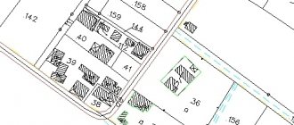
Sample application for establishing the boundaries of a land plot.
Required documents
You must have:
- copy of the application;
- power of attorney, but only if you have delegated powers to another person who will represent you in court;
- a receipt confirming your timely payment of the state fee;
- documentation certifying the authenticity of the facts on which you rely in order to resolve the land dispute;
- documents confirming the right to ownership of the site;
- documents that confirm that you comply with the unconditional procedure for pre-trial “smoothing out” the dispute;
- calculation of the disputed or recovered amount of money, which must be signed by the plaintiff or a person representing his interests.
Trial
In order to obtain a positive court decision for you in the case under consideration, you must present facts that prove your case. Undoubtedly, this is a rather complex procedure that requires both procedural and mental activity. Read the rules for land surveying here.
But, nevertheless, every plaintiff wants to quickly find out the court’s decision and how positive it will be for him. Therefore, let's talk about how the deadlines for issuing a “verdict” by the judiciary are set.
So, procedural time frames are divided into two types: the period of examination of the claim by the court and the period of performance of actions (procedural) by people who take part in the case. Moreover, deadlines are also divided into the following types: established by the court itself and by federal law.
But, we will not go into the details of the legislation of the Russian Federation, since your lawyer will inform you about all the nuances. The most important thing you need to know is that the decision on your case must be announced within two months from the day the application was received by the court. How is land surveying carried out or the cost of land surveying? Find out by following the links.
Is it possible to challenge the survey results?
Naturally, every owner has the right to challenge in court the invalid results of land surveying of his plot of land. But, in order to solve the problem that has arisen, it is necessary to first find out why it arose. Firstly, a mistake could have been made by the cadastral service when surveying your land.
In this case, the responsibility lies not with the organization itself, but with the engineer who was involved in setting the coordinates and made a mistake, entered this erroneous data into the boundary plan and registered it with the cadastral chamber.
The main part of preparing evidence indicating that the survey results are erroneous is the accurate drawing up of your land plot plan.
It is necessary for the cadastral service engineer to prepare a plan (landmark) where he indicates the location of the boundaries of a certain area, and also indicates in the conclusion the reasons for the imposition of boundaries and provides his proposals for resolving this issue.
After which you need to file a claim in court so that the judicial authorities determine the correct location of your land. In order for the court to take your application into account and begin considering the case, you must provide written evidence of your case.
Article No. 71 of the Code of Civil Procedure of the Russian Federation stipulates that evidence can be considered: contracts, acts, business correspondence, certificates, as well as other materials and documents that are made directly in the form of a graphic or digital record, and also received through electronic, facsimile and other communication, or in any other way in which the document can be verified for authenticity.
In addition, the boundary plan is perfect as evidence.
Therefore, a competently and correctly drawn up land surveying plan for your land plot will serve as an excellent addition to the results of the forensic expert’s conclusion. In addition, if he also establishes the presence of errors in the process of surveying the defendant’s land, then he will help you challenge the biased expert opinion.
See the land project plan here.
How to challenge a neighbor's land survey
To prevent land surveying from being declared illegal, it is enough to wait 30 days from the date of notification to neighbors through the media. At the end of this period, all necessary measures can be carried out to identify characteristic points of the earth. If in the future the neighbors file a statement of claim with a request to invalidate the survey results, you will have strong evidence that you are right.
The area and outline of each land plot must be reflected in the land survey. This document is a sample for adding individual ownership data to the Unified State Register and assigning it an original cadastral number. You can peacefully resolve the issue of land surveying and not file a lawsuit if a competent cadastral engineer is responsible for carrying out the procedure.
20 Jul 2020 stopurist 290
Share this post
- Related Posts
- Benefit amount in early pregnancy in 2020
- How is the purchase and sale transaction of an apartment completed using maternity capital?
- What doctors are needed for a certificate at the traffic police?
- Maternity leave in 2020 calculator online
To sum it up...
If you are faced with such a situation, then feel free to start looking for a lawyer who will represent your interests in court. The most important thing you must do is to “arm yourself” with all the necessary documents and defend your point of view to the end.
We hope that this article has helped you gain a general understanding of the causes and effective methods for solving the problems of determining the boundaries of land plots.
How to challenge land surveying
In accordance with the Federal Law “On the State Real Estate Cadastre”, the location of the boundaries of land plots is subject, in the manner established by Federal Law, to mandatory coordination with interested parties in the case of cadastral work, which results in the preparation of documents for submission to the cadastral registration body of an application for accounting for changes in one of the specified land plots plots in connection with clarifying the location of its borders.
I have in my hands a cadastral passport of the plot where its number, size and address of location are recorded, there is a court decision on recognition of property rights by inheritance, that is, on the basis of this I can register it and receive a certificate of title and then later clarify the boundaries of the location at this address (make a boundary plan). Previously, there was only an extract from the household register that my deceased uncle had the right to USE a land plot at an address without a cadastral number, how can I now prove that my neighbor has subdivided my plot of land leased to her?