- home
- Useful articles
- Check the land surveying by cadastral number
30.05.2018
Surveying
– a set of certain actions aimed at establishing a clear location of the site, and also helps to determine the cadastral boundaries of land plots. All main characteristics and information about the land plot, as well as the cadastre number, are located in the cadastre passport. Many land owners need to check whether land surveying has been carried out on a given land plot.
How can you determine from the documents that this procedure has been carried out?
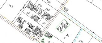
Especially for this, you need a cadastral plan, which can be found on Internet resources through the Public Cadastral Map.
This way you can check the cadastral boundaries of land plots online. Just find the area you are interested in on our cadastral map.
If your site has not undergone the land surveying procedure, then you will not find its plan on the Public Cadastral Map. In the summary of information about the allotment, you will not find the name and surname of the specialist who carried out the operation to determine the boundaries. Based on the presence and absence of this information, we can understand whether all required boundary measurements have been carried out. It happens that the site is designed without land surveying, i.e. within a certain cadastral quarter it exists, the documents indicate its area, but there are no boundaries. In this case, it is necessary to carry out the land surveying procedure before no one else takes your place.
How to find the cadastral number of a land plot
There may be different situations when you may need information such as the cadastral number of a land plot.
Before going to the Department, you must collect a complete package of documents. Since March 1, 2008, land surveying for transactions with them has been canceled in accordance with the law on the real estate cadastre.
And many people initially have difficulty finding this kind of information.
The number of land plots is composite. It includes information such as the number of the district itself, where it is located, the number of the region, quarter, and, directly at the end, the number of the site itself. Finding the cadastral number of a land plot on a public cadastral map is not difficult, just 2 steps. Firstly. it is necessary to find documents indicating the cadastral number of the land plot. Old-style documents issued before 2001 will not help you in finding a number and you will not be able to find a site by number.
Secondly. To search for a cadastral number, you should use Internet resources, i.e.
Rosreestr website.
Determination by contacting government agencies
A resource that will help you check the boundaries of a plot by cadastral number can be a cadastral passport or a cadastral extract.
To obtain these documents, we should contact the MFC or the official branch of Rosreestr. First of all, you must provide personal information (first name, last name, patronymic, passport details, email, your signature and mobile phone number).
There are several options for issuing a cadastral passport. This document can be sent digitally via email, delivered in person, or sent by regular mail. If you are a proxy, your passport and power of attorney should be added to the list of all necessary documentation. The approximate time frame for issuing passports is 7 days. The fee for issuing a document is limited to the state duty of 250-750 rubles.
Cases when a land surveying procedure is necessary
The information provided by the boundary measurement procedure is useful in a number of the following cases:
- Determining the clear boundaries of your land plot (especially if it has a complex configuration). Restoration of borders and their ordering.
- In case of a dispute about the legality and propriety of your rights to property. The information provided by the land surveying procedure will help protect you legally.
- Resolution of conflicts related to the boundaries of land plots.
- Dividing a land plot into smaller territorial units or, conversely, adding additional area to it.
- Separation of property from collective ownership.
- Construction of new buildings in this area.
Typically, a cadastre passport is issued upon application. Owners submit applications in cases where they need the information that the cadastre passport provides about the process of determining the location of a site, as well as other information about the property.
The document is required when resolving any civil legal conflicts, and plays a fundamental role in proving your case and protecting your rights.
Without this paper, you will not be able to carry out such significant actions as:
- Sale, purchase of land plots.
- Certify documents for transfer of property by inheritance.
- Pledge.
Is it possible that the cadastre passport does not contain information about the land surveying procedure?
A cadastre passport can be issued without the mandatory land surveying process. This is due to the fact that at different times various requirements were established into which property owners had to fit. The legislative act on the dacha amnesty gave many citizens a chance to obtain rights to a plot in a simplified manner. Therefore, many were issued cadastral passports without undergoing a direct process of determining the boundaries of the cadastre. This also occurs in the case of shared ownership.
conclusions
Surveying process
– a very important procedure that will help you in many property conflicts, as well as for transactions of purchase and sale, inheritance of property, rental and division with other owners. It is possible to check the characteristics of land surveying and its implementation using the cadastral number. To do this, you need to turn to the Internet for help from the Public Cadastral Map, or submit a request to government agencies (Rosreestr, Multifunctional Center) and receive the paper in person, or receive it by mail, including electronically.
On our website you can obtain the documents you are interested in from Rosreestr online and in an accelerated manner.
How is land surveying carried out?
The basis for initiating the land surveying procedure is a written statement from the customer of the work. In this case, the customer must either be the legal owner or use the land under various conditions. It can be:
- unlimited use;
- lifelong inheritance;
- property transaction.
The filing party may be a legal entity or an individual and may also have an interest. In the latter case, each owner of his share must submit an application. As an option, the application is submitted by a representative of all parties. And one more thing: when contacting the relevant services, the applicant must be ready to document his rights.
You need to start the process by contacting the geodetic company closest to the location of the land, which must have a license to carry out this type of activity. The customer can be either the landowner himself or his representative. The submitted application must be accompanied by a package of documents (for this you need originals and copies of documents):
- applicant's passport;
- notarized power of attorney (for representatives);
- title document (this could be, for example, a purchase and sale agreement or an act of allotment);
- Rosreestr certificate on the form of title to the plot;
- cadastral number - if available.
Sale of land on the Cape near the Volga 88 acres, 165 km from the Moscow Ring Road VIEW
Main stages of the procedure
Current legislation very clearly outlines the order in which the described procedure is carried out. Land surveying takes place in several stages:
- the applicant collects all the necessary documents - clearly establishing ownership and others, as well as additional information and reference materials relating to this plot;
- clarification of boundaries and coordination with adjacent land users - a geodetic survey is carried out to determine the area and lengths of all sides;
- drawing up a boundary plan based on the information received, which is necessarily included in the plan in the appendices;
- transfer of the drawn up boundary plan to Rosreestr;
- registration of a cadastral passport.
Features of land surveying of your own land plot
Usually a citizen has in his hands a document certifying his ownership of the land. In addition to this, the owner of the plot has a paper that became the basis for issuing a certificate of ownership:
- donation and sale agreements;
- inheritance paper;
- administration resolution on the allocation of land, and so on.
Make good, legible copies of all these papers. Their notarization is not required by law. But officials in regions and cities (except Moscow) may require this to confirm authenticity. Additionally, it makes sense to order an information sheet from the local architecture office that contains a variety of important information, including location (diagram), zoning features, and other data.
Who to contact?
Find a land surveying company in your city. Keep in mind that only a cadastral engineer with the appropriate qualifications and a special certificate, who can either work for such a company or be an individual entrepreneur, has the right to make a boundary plan correctly.
Study current prices, find and read customer reviews. Now, after you are convinced of the affordability of the services and the high qualifications of the contractor, proceed to the process of concluding a contract.
What types of fireplaces are there for country houses?
Where is it better to have a country house: in a village, village or cottage community?
What is important to consider when choosing a new building?
Classifiers and codes of land plots. What are they needed for?
Installation of cameras and video surveillance inside the house. For what? And how to choose?
Kievskoye Highway: one of the most promising places to buy real estate
Purchase and sale of houses and plots. What documents and registration costs will be required?
How is tiling done?
What paint to paint the wooden facade of a country house?
Samostroy: what does it include? How to legalize unauthorized construction?
Divide the payment for the work into two parts - prepayment and final payment after completion of all work. Agree with the engineer about the time at which he will arrive at the site to carry out all the necessary measurements and studies.
It is especially important to pay attention to the correctness and accuracy of the contract. This document will help you defend your rights if land surveying work is completed behind schedule or with insufficient quality.
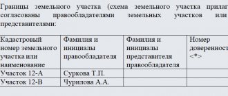
Now comes the most difficult stage. On it, the boundaries determined by measurements are agreed upon with adjacent land users. The agreement is carried out by a specialist, talking with each of the neighbors. As an option, a meeting of interested parties is convened, and approval is carried out based on its results by a list. If disagreements arise, special acts are drawn up as appendices to the boundary plan. An act of agreement is drawn up, and disagreements, if any, are settled in court.
Finally, the finished paper is handed to you. Immediately, without delay, submit it to the Rosreestr authorities. There they will check it and register your land. In the age of information technology, it is most convenient to issue a boundary plan to the customer in electronic form. In the same way, on electronic media, the paper is submitted to government authorities. However, you will need to attach a paper version printed on a printer to the electronic version.
Soon after submission to Rosreestr (if there are no errors or inaccuracies in the boundary plan), you will be given a cadastral plan of the site. This paper indicates, in particular, that all available information about this land ownership, its owner and boundaries is entered into the State Real Estate Cadastre.
The land surveying process cannot be called particularly difficult. But it requires unconditional compliance with all rules, the most current requirements of current legislation and accurate execution of all work. Therefore, it is recommended to carry it out only with certified specialists of the highest qualifications.