The GKN (state real estate cadastre) today is under the purview of Rosreestr and is a systematized electronic information database in which data on all registered real estate objects is stored and processed. This database also contains data on the state borders of the country, the delineation of subjects and individual territories, and the designation of areas with conditions for special use. The full list of information that must be entered into the electronic cadastral register is regulated by Federal legislation.
Since the state cadastre is an information resource, interested parties can obtain information from the State Property Committee by submitting a corresponding request in person to Rosreestr, through the Multifunctional Center or directly from the official website of Rosreestr online.
In general, the cadastral register displays information that relates to the real estate objects themselves, the boundaries of individual plots and the division of settlements, territorial divisions, and zones with special purposes. The structure of the database includes recording unique characteristics and additional information on objects.
Unique characteristics are designations of the type and category of the object, its belonging to any fund, an individual cadastre number, the date of registration of the property with the state.
Dear readers!
Our articles talk about typical ways to resolve legal issues, but each case is unique. If you want to find out how to solve your specific problem, please contact the online consultant form on the right →
It's fast and free!
Or call us by phone (24/7):
If you want to find out how to solve your particular problem, call us by phone. It's fast and free!
+7 Moscow,
Moscow region
+7 Saint Petersburg,
Leningrad region
+7 Regions
(free call for all regions of Russia)
Location of territorial boundaries
You should also know some nuances about what information relates to data on the boundaries of land plots in order to understand what exactly to make a request to the information resource about:
- Lists of coordinates (clear points indicating boundaries);
- Descriptions of securing lines on the territory;
- The accuracy of point coordinates is rounded to 1/100 of one meter;
- Designation of error in the coordinate system;
- Cadastral numbering of the area of interest;
- Additional data that is entered when describing certain fragments of the site;
- Presence and location of artificial and natural objects;
- The area of the land plot in square meters and rounded to the nearest unit, taking into account a single permissible error.
Reference information in the cadastre also includes the type of real estate (plot of land, house, non-residential building, separate premises, apartment, etc.), exact location with contour characteristics, numbering of floors, if there is a number of floors, placement of the object on the floor. In addition, the structure of the electronic resource is very ramified, which allows you to enter a lot of additional information, additions and changes while preserving information that is no longer relevant.
The easiest and fastest way to find out information from the State Tax Register is to order an extract from the Unified State Register online here or through the widget below. Around the clock, in just 5 minutes, you will receive complete information about the property according to official data from Rosreestr.
Payment for information from the State Tax Committee
| No. | Name of service | F | YU | F | YU |
| Paper form | Electronic form | ||||
| 1 | 2 | 3 | 4 | 5 | 6 |
| 2 | Passport | 200 | 600 | 150 | 300 |
| 3 | Extract | 400 | 1200 | 150 | 300 |
| 4 | Plan | 800 | 2400 | 150 | 300 |
| 5 | Technical plan | 800 | 2400 | 250 | 500 |
| 6 | Others | 200 | 600 | 50 | 100 |
Additional information GKN
Additional information on land plots includes:
- Assigned registration numbers (cadastral or conditional);
- Location (address or detailed description, if the address is not assigned, region, town, street);
- Address objects that exist on the site (if there are no such objects, this is also displayed in the register);
- Permits for use - category of land, restrictions imposed on the basis of urban planning regulations or acts of local government;
- Cadastral numbering of each property located on the territory;
- Existing forest zones that are located within a certain land plot.
Before contacting Rosreestr, even online, without leaving your home, it is important to clearly formulate what exactly you need to know and for what purpose, when this information will be needed, and in what form you need to receive it.
GKN objects
The objects of the state real estate cadastre are all plots of land included in the territory of the Russian Federation, plus the state cadastre of real estate objects - these are all immovable property objects while they are registered.
All of them are usually owned by:
- individuals;
- legal entities;
- enterprises and organizations;
- land committees and mayors;
- administrations and federal self-government bodies.
Data about all specified objects is stored in two formats - digital and paper. Each object has its own unique cadastral number. Thanks to the latter, the dislocation of the object and its owner is determined.
What else can you find out?
The GKN information resource also includes information about objects of natural and artificial origin: lakes, rivers, water reservoirs, ponds that are located on land plots. Data about them is entered into the electronic database when real estate is registered with the state.
The confidential information section contains information by which a person who has the right to lifelong use or inheritance of property can be contacted, for example, postal address, email. Information is also available regarding:
- The presence of burdensome and limiting circumstances - their type, duration, to whom they apply, details of the accompanying documentation on the basis of which the entries were made, when they were made;
- Territories that are combined into a complex, their registration numbers and the dates of their assignment, the total area in square meters, rounded to one and indicating the error, a description of the boundary lines;
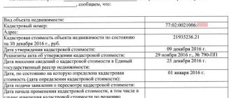
- The cadastral value of the plots, when it was determined, on the basis of which document, the average cost of land in the region, municipality;
- Cadastral engineer, who is responsible for carrying out cadastral work at the site (surname, initials, qualifications, how it is confirmed, what legal entity this specialist belongs to, what work he carried out);
- Liquidation of an object (when it was deregistered);
- The current status of real estate.
What is GKN
Cadastral relations arise when carrying out cadastral registration of land plots, buildings, structures, premises, objects of unfinished construction, as well as when preparing documents necessary for carrying out cadastral registration.
Currently, these relations are regulated by the Federal Law “On the State Real Estate Cadastre”, which was combined with the adoption of a previously separate system of state land cadastre and registration of other real estate.
The adoption of this law marked the beginning of the reform of the cadastral registration of real estate, which continues today and is aimed at ensuring improved quality of work and interaction with real estate accounting by creating a unified state real estate cadastre (GKN).
Before the adoption of the Cadastre Law in Russia, several real estate inventories were carried out (land, urban planning, forest, water, cadastre of deposits and mineral deposits, etc.).
Fundamental among them was the land cadastre. This is explained by the fact that, firstly, all other objects to be considered are located on the ground, and secondly, it is the first among all real estate cadastres.
By the beginning of the state land reform, it included:
- Registration of land plots.
- Accounting for the quantity and quality of land.
- The set of natural soil properties.
- The economic value of land, which became the basis for calculating land tax on real estate.
The main regulatory document defining data on real estate was the Regulation on the procedure for the state land cadastre. According to this document, it contains some reliable and necessary data on the natural, economic and legal status of the land and was carried out to ensure the rational use of land resources.
At that time, the land registry was the mechanism for registering land. Today it also includes data on real estate objects.
Receipt of data by citizens
The electronic database of the state cadastre of real estate is, at its core, both an electronic and paper format for storing and processing information to meet the needs of Russians.
This archive contains data on all objects located within the Russian Federation. Every interested person has the right to submit a request for information from the State Tax Committee by presenting a personal passport or his or her SNILS. The time frame within which the requested information is provided is regulated by current government orders. So, for example, if any request is received that does not relate to territorial plans, Rosreestr is given no more than five working days to respond to it. If you need data on the territorial plan, the processing time for such a request is up to fifteen working days.
The State Property Committee register actually contains data on all registered objects, plus background information on the papers that served as the basis for their inclusion and thanks to which they can now be obtained. Most of them are provided not only to owners of real estate.
In what form is the information submitted?
- Cadastral passports for real estate objects;
- Copies of documents according to which data on objects was entered into the state register database;
- Cadastral plans of land plots;
- Other forms permitted in accordance with current Russian legislation.
The type of provision of information from the State Tax Committee, which is requested by a person in electronic format, is sent to an email address (XML version of the document) or is issued in a standard paper format, if the applicant wishes and has the opportunity to appear at the relevant authority in person.
Procedure online
To submit the appropriate request (application) to receive information from the State Property Committee online and for free, you must go to the official website of Rosreestr, go to the section for obtaining the required data from the state cadastre and fill out the form that pops up.
The electronic application form is divided into three parts. In the first, you need to select the appropriate type of information that is needed about real estate from the register, and manually enter the individual object number according to the cadastre, if it is known. If it is unknown, you need to enter the exact address of the location of the property of interest. Next, you need to indicate in what form the applicant wishes to receive ready-made GKN information.
In the second part, you must enter information about the applicant. In this case, you must have your personal passport with you. The third part is a form for checking and submitting an electronic request online. When a request is submitted, a page will appear with the characteristics of the submitted request. If the data is not saved, there is nothing to worry about, since reference information with the application number, its code and bank account details where the state fee for the service provided by Rosreestr should be transferred is sure to be sent to the specified email address.
After all the steps described above, the process of obtaining information from the State Property Committee can be controlled directly on the website. To do this, you need to follow the link indicating the payment code and enter it (received in an email). What is very convenient, the State Property Committee and the online Rosreestr are available 24 hours a day, seven days a week, and you can order information as many times as you like.
In what form can I obtain information from the State Property Committee?
Depending on the situation: buying a house or selling it, resolving disputes with neighbors regarding the boundaries of a plot, etc., you may need certain data about the object. In this regard, the GKN provides the opportunity to obtain information in several forms, each of which differs in the volume of data and its privacy.
Cadastral passport
a passport is one of the required documents provided to register the transfer of ownership of an object.
https://www.youtube.com/watch?v=ytcopyrightru
Contains data on forms B1-B4:
- Cadastral number of the object. The number is unique and it contains the basic and main information about the site, house or apartment. The basis for generating the number is cadastral data: region, district and quarter of the location of the real estate (address).
- Information about dimensions (area);
- The material from which the building/apartment is made;
- Year of construction;
- Cadastral value.
| No. | Form number | Content |
| 1 | 2 | 3 |
| 2 | IN 1 | Data about the object contained in its number - address and category of land, as well as information about the owner, cost, area, etc. |
| 3 | AT 2 | Site plan with a diagram, if land surveying was carried out. Otherwise, data in form B.2. will not be. |
| 4 | AT 3 | Information about the restrictions associated with the use of the object. For example, for land plots, there are restrictions related to the location of the object in a protected area, water protection zone, etc. |
| 5 | AT 4 |
- It is worth noting that only those objects that have been registered with the state registration authority - in the Rosreestr branch at the location of the object - have a passport. Otherwise, when applying, the object is first registered, and then its cadastral passport is drawn up.
Cadastral extract
It is formed on the basis of the data specified in the information base of the State Tax Committee. Roughly speaking, it duplicates the information specified in the passport. However, the extract contains complete data about the object. The list of information required to be provided is compiled by the customer independently.
- Information from the extract is necessary for carrying out land surveying work, as well as for clarifying the boundaries of the site in case of disputes.
The information in the extract is provided using forms KV.1-KV.6.
| No. | Form number | Content |
| 1 | 2 | 3 |
| 2 | KV.1 | Data B.1 of the passport |
| 3 | KV.2 | Data B.2 of the passport |
| 4 | KV.3 | Data on the internal boundaries of the site, if it is divided. To be filled in if land surveying has been carried out. Otherwise – data according to the form KV.3 – KV. will not be. |
| 5 | KV.4 | |
| 6 | KV.5 | Data on the boundaries of the site, as well as basic information about the neighbors: numbers, information about the owners, etc. |
| 7 | KV.6 | Data on border turning points using a dual coordinate system. |
We invite you to familiarize yourself with the terms of non-disclosure of the terms of the agreement between individuals.
The main purpose of the extract is informative.
- Available for receipt even for those categories of objects that are not registered with Rosreestr. However, in this case, the extract will contain information only about the location of the site and its boundaries, as well as the fact that the object is not registered.
Contains information about the site, as well as objects located on it. Those. these are forms B.2. and KV.2. passports and statements.
It is mainly used by engineers to carry out cadastral and land surveying work; therefore, it is not particularly significant for other categories of persons.
- The legal significance of the territory plan lies in the fact that without it it is impossible to formalize ownership of land or an object, as well as to register it in the cadastral register.
The plan reflects to the smallest detail all the objects located in the described territory. The required attribute is an image with a clearly reflected boundary of the site.
| No. | Form number | Content |
| 1 | 2 | 3 |
| 2 | KV.1 | Data B.1 of the passport |
| 3 | KV.2 | Data B.2 of the passport |
| 4 | KV.3 | Data B.2-B.4 passport |
| 5 | KV.4 | Detailed close-up diagram of each part of the site. |
| 6 | KV.5 | KV.5 extract data |
| 7 | KV.6 | KV.6 extract data |
A document drawn up according to the sample, reflecting the cost of the object.
- First of all, the cadastral number contains the value of the object. Since the number reflects information about the region, district and quarter, the territory on which the property is located. This is extremely important information when purchasing a plot of land or a country house, since the fertility of the soil directly depends on its location.
The certificate is issued for each of the objects separately. Those. if there is a house on the plot, then a certificate for the plot itself and the house located on it will be drawn up separately.
Data on the value of the object is updated every 5 years. However, in legal transactions, certificates whose validity does not exceed 1 year are accepted.
These could be:
- technical or boundary plan,
- administrative resolution on the basis of which a change in the permitted type of use of the land plot was made
- a document confirming the legality of changing the purpose of the premises or building,
- a document with information about the owner or address of the property, etc.
We invite you to familiarize yourself with the Features of the transfer of a civil servant