When carrying out various works related to land plots, or carrying out transactions, it is necessary to have a list of necessary documents, which often include a land survey plan.
The process of land surveying is the implementation of complex actions aimed at establishing the exact location and dividing boundaries on the ground .
When is it necessary to draw up a boundary plan?
Based on clause 1 of Article 38 of the current law “On the State Real Estate Cadastre”, the drawing up of a boundary plan is carried out on the basis of the current cadastral plan of land plots belonging to various owners.
The reason for starting the necessary work on drawing up a plan may be an extract from the cadastre with the entered accurate data about the land plot. The plan must necessarily reflect all the information contained in the state register of real estate objects, indicating the latest information on changes in the actual size and configuration of land plots. The purpose of the boundary plan is to accurately determine and record the boundaries of the site in the cadastral register.
The need for a boundary plan arises when it is necessary to submit an application indicating the changes that have occurred in the current cadastral registration of objects during the purchase, sale or other actions related to a change of owner:
- when entering new data on the characteristics of the land plot;
- dividing the site into several new ones;
- redistribution of several plots;
- consolidation of plots;
- correction of errors entered into the registry.
etc.
All work and paperwork are carried out by specialists who are qualified and have the appropriate authority to carry out land management work .
How to register a “cut-in” under the new Land Code
That is, a citizen turns to any cadastral engineer to prepare a boundary plan , submits it to the cadastral chamber and receives a cadastral passport for a new plot.
The types of objects that can be placed on lands or land plots that are state or municipally owned, without the provision of land plots and the establishment of easements (except for the objects specified in paragraphs 1 and 2 of this article), are established by the Government of the Russian Federation. The procedure and conditions for the placement of these objects are established by the regulatory legal act of the constituent entity of the Russian Federation.
12) the layout diagram of the land plot attached to the application for redistribution of land plots was developed in violation of the requirements for the land plots being formed or does not comply with the approved draft territory planning , land management documentation, or regulations on a specially protected natural area;
An agreement on the redistribution of land plots is the basis for actions with municipal and state lands. The agreement itself is concluded between authorized bodies. It must reflect the obligations of both parties related to ensuring the formation of land plots.
A protocol is drawn up in relation to all land plots formed as a result of redistribution. The Protocol provides cadastral numbers and areas of the original land plots participating in the redistribution.
How does the redistribution of land plots with municipal land occur?
A protocol is drawn up in relation to all land plots formed as a result of redistribution. The Protocol provides cadastral numbers and areas of the original land plots participating in the redistribution. If, during redistribution, land plots are formed from lands that are in state or municipal ownership, the Protocol indicates: the number of the cadastral quarter within the boundaries of which the specified lands are located, their category and area.
- To combine areas . If the plots have common boundaries, and there is an agreement between the owners, they can be combined into one. In this case, the old plots are removed from the cadastral register and cease to exist, and a newly formed large plot is entered into the register. It is for him that land surveying is carried out. The cadastral engineer will note the results of boundary changes, taking into account the data on the previous areas. There is one caveat here. Usually, when merging, the boundaries of old areas have already been established. Other situations do not occur often. This simplifies the work in terms of agreeing on new boundaries with neighbors, since it is possible to use old technical documentation for the land.
- For redistribution . This situation is a little similar to the previous one, since several sections are first merged into one. The difference is that during a merger, the newly formed plot is registered in the cadastral register as an independent unit, and during redistribution, it is again divided into several, but with new boundaries. The peculiarities of the redistribution procedure also determine the nuances of land surveying. The land survey actually contains two plans - for the unification of lands and for their subsequent division. The redistribution procedure has an important advantage - it allows two surveys to be carried out simultaneously.
- To form a new area . This is necessary if the land is allocated to you from municipal property. To register the resulting site, you will need a boundary plan and other technical documentation. A similar situation arises when allocating ownership of a plot of land from SNT.
- To clarify the boundaries . There are many reasons why land surveying may be required to clarify boundaries. These include conflicts with neighbors, legal disputes with third parties, clarification of the area to reduce taxes or rental rates, identified errors, and much more. Regardless of why the owner needs to clarify the boundaries of his property, land surveying will be required.
- First, the cadastral engineer will collect the necessary information about the area under study.
- After this, it is necessary to notify all interested parties in the procedure, since they have the right to be present during the survey.
- Carrying out the field stage, during which the cadastral engineer carries out the necessary geodetic work, surveying the site, coordinates of turning points, etc.
- The survey results must be consistent with the neighbors. An official document confirming that there are no disputes between interested parties and everyone agrees with the established boundaries is a signed act.
- Registration of cadastral work results, preparation of conclusions.
We recommend reading: Part 5, Article 228
We prepare the boundary plan correctly
- Changing boundaries. Such situations include the merger or division of a plot already mentioned above. As a result, new objects are formed that are registered in the cadastral register. This means that it is necessary to prepare technical documentation for them.
- Boundary disputes with neighbors. A small dispute with neighbors can be resolved with the help of a boundary plan, but if you find yourself in a situation of intense conflict or litigation, we recommend preparing as complete a package of technical documentation as possible. In this case, the boundary plan will be confirmation that the boundaries have been established and agreed upon.
- Tax disputes. Property tax depends on the area of the plot. If you think that you are being charged too large payments or for some reason the area of your land has changed, a boundary plan will help resolve the controversial situation with the tax authorities.
Drawing up a boundary plan: procedure
In accordance with clause 4 of the current law “On the State Real Estate Cadastre”, the entire list of preparatory work required for drawing up a land survey plan is carried out together with the implementation of special cadastral work carried out by a cadastral engineer .
To begin carrying out complex actions, a concluded contract for contract work .
The boundary plan is signed by the executor - a land surveyor and certified by the seal of the geodetic organization. The survey plan displays the boundaries of the surveyed area and the necessary information about the changes made.
Before carrying out complex land surveying work, two days before they are carried out by sending postal notices.
The opinions of the owners are necessarily recorded in a special act drawn up for approving the boundaries of the plots. The act is signed by the present owners of the plots or their proxies, certified by the land surveyor with the seal of the geodetic organization that performed the survey work, as well as by the land surveyor of the local village or city administration with the approval of the corresponding seal.
In cases of disputes regarding land surveying, the opinions and disagreements of the parties are recorded in a document describing the reasons. Dispute resolution is carried out in the courts or administratively.
To draw up a boundary plan, individuals must submit the necessary list of documents:
- cadastral passport;
- a copy of the plan of the site in question;
- cadastral plan;
- statement of the need to carry out work;
- a copy of the applicant's passport;
- original certificate of ownership of the land plot.
The boundary plan contains all the necessary information taken from the cadastral extract and cadastral plan.
The plan displays information:
- on the merger of two or more plots;
- when dividing one plot into several plots;
- the size of the plot is indicated when allocating a share, purchasing municipal or state property.
What conditions are necessary for the formation of sites?
There are quite a lot of conditions under which the formation of land plots is allowed. Let's take a closer look - after all, without knowing some rules, it will be impossible to allocate a plot of land from municipal or state lands. Some restrictions can be eliminated, but some will have to be accepted.
- A fairly obvious condition is that there are no other owners in the place where the plot is planned to be allocated. Or if there is already an approved location plan for this territory, but land surveying has not yet been carried out. After all, it is valid for 2 whole years.
- The formed plot must be greater than the minimum and less than the maximum size established by town planning regulations or local governments for this category of land. You should check this information with your local administration. But, for example, when dividing a land plot (also a type of formation) or when registering “additions”, such norms often do not apply, since they conflict with the rights of the owner/s of the land plot. This is described in detail in the above articles.
- It is necessary to take into account the rules of urban planning. The formed land plot must be within the boundaries of one territorial zone (with the exception of linear objects).
- It is impossible to form a site if this will lead to the impossibility of the permitted use of real estate located within its boundaries or in the neighborhood.
- It is impossible to create a site on existing roads and passages, thereby limiting the rights of third parties.
In any case, after reading these conditions, we recommend that you consult with our specialists about the possibility of forming a loan. There are many different factors that can influence your decision to form a site. Often, in order to figure it out, you need to provide us with the cadastral number of neighboring plots or schematically draw the projected boundaries of the plot on the cadastral map. After familiarization, you can already understand whether it is possible to form a site. It is likely that a topographic survey of the area will need to be carried out to ensure that the site is suitable for education. The topoplan will be useful to both the person interested in the formation of a land plot and the municipality, in the event of an ambiguous decision on approving the possibility of formation.
So is it possible or not to form? Undecided?
Ilya Chernyshev
Ask a Question
Where and how to make a boundary plan
When carrying out land surveying work, it is necessary that information is received by all authorities that record and register changes related to land plots (plots) - government organizations that register all real estate objects (registry of subjects, local, state register).
To obtain a boundary plan, you must perform a number of actions:
- prepare the entire list of necessary documentation ;
- submit an application to the cadastral chamber;
- carry out the full range of work related to measuring the area of the site ;
- pay the state fee;
- submit the required documents to the cadastral chamber .
The cadastral chamber is responsible for issuing the boundary plan. Chamber staff perform a full analysis of all submitted documentation, clarifying details, and draw up a document.
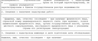
Sample boundary plan sections
The boundary plan of the site must contain the necessary information, which can be reflected in a paper document or on an electronic medium, where there must be an electronic signature of the land surveyor.
The main sections of the boundary plan include:
- the entire list of information;
- measurements taken on the ground to determine the location of a piece of land and area;
- land plot diagram;
- detailed drawing of the entire site and its parts;
- geophysical map;
- a copy of the notice in the media.
Features of filling out the boundary plan of a land plot
When filling out a boundary plan, a number of features are taken into account:
- Availability of signatures of responsible persons and seals of organizations certifying documents.
- Correspondence between the actual size and area of the land plot and the drawn up plan.
- Registration of disagreements based on the survey results in writing with the signature of all parties.
- The preparation of the boundary plan must be carried out taking into account all the provisions on maintaining cadastral records of real estate.
- Compliance with actual data (passport data, accounting data obtained during measurements).
Below are examples (models) of boundary plans drawn up for various purposes. You can use the link in pdf format:
- Clarification of the boundaries and area of the site - .
- Allocation of a multi-circuit land plot located in several cadastral blocks - .
The changes made to the legislation of the Russian Federation make it possible to significantly speed up the process of preparing documentation with a reduction in the time frame for the entire list of works on drawing up a boundary plan.
Ways of education
Based on how land plots are formed, there are two types:
- Land plots can be formed from other plots previously registered in the cadastral register through division, allotment, redistribution and consolidation. By following the links you can learn more about these methods of education.
- However, usually “Formation of a land plot” means the allocation of state or municipal lands. The boundaries of the site are being established for the first time . At the same time, it is formed separately, without affecting or changing the boundaries of other areas. Further we will describe this method of education.
It is important - if you want to form a plot of state or municipal land and immediately attach it to the existing one (standing on the cadastral register), the so-called “cutting” or “cutting” among the people, then this will be a formation during redistribution.