Home / Land, dacha, construction / Documents and legislation / Land plot / Cadastral registration / Number
Back
Published: 01/28/2018
Reading time: 6 min
0
1435
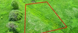
The coordinates of a land plot make it possible to determine its exact location on the land territory. They are assigned to the site after the completion of the land surveying procedure. The survey document drawn up based on the results of the work indicates the cadastral coordinates of the nodal points of the boundaries of the site. It is these data that are entered into the Unified State Register of Real Estate as a mark on the actual location of the plot on the land territory. You can find out these coordinates by the cadastral number of the plot.
- The procedure for obtaining data from a public cadastral map
- Obtaining data from the Unified State Register of Real Estate
Geodata of the land plot
From January 1, 2020, the Russian Federation will abolish the possibility of making transactions with land plots for which the state real estate cadastre does not contain information about the location of the boundaries. This norm is introduced on the basis of the Federal Law of December 22, 2014 No. 447-FZ “On Amendments to the Federal Law “On the State Real Estate Cadastre” and certain legislative acts of the Russian Federation” and applies to land plots provided for gardening, personal farming, country farming, gardening, individual garage or individual housing construction. Thus, if cadastral work in relation to a land plot is not carried out in accordance with the procedure established by law before January 1, 2020, then such a plot cannot be disposed of (sold, donated, exchanged, mortgaged, etc.) regardless of whether it exists or there is no certificate of ownership of this plot or a lease agreement for the land plot. Currently, land plots registered in the cadastral register without land surveying are considered previously registered. When receiving a cadastral passport for such plots, in column 15 “Special notes” it is indicated - “The boundary of the land plot is not established in accordance with the requirements of land legislation.” Today, Russian legislation does not oblige the owner of a land plot to carry out the land surveying procedure. But due to the lack of clear boundaries of the land plot, a lot of disputes arise between neighbors, even leading to litigation. After all, the essence of boundary work is to accurately determine the boundaries of the site and reflect them in the cadastral passport. Land surveying may be necessary if, for example: 1. The owner of a large garden plot (with an area of 12 acres or more) is going to divide it. For example, to sell one plot and pass another by inheritance. It is impossible to carry out such transactions without land surveying. It is impossible to divide a large area that does not have clearly defined boundaries. 2. There were disagreements with neighbors regarding borders. Russian courts annually consider thousands of cases related to so-called “neighborhood wars.” If people living in the neighborhood cannot agree for years on where the fence should be located, or on whose territory the pipe runs, land surveying is the best solution for them. 3. It is planned to sell the plot. Land surveying for sale is not yet necessary. The main thing is that you have a cadastral passport, which can now be obtained using a simplified procedure. But it is much more difficult to find buyers for a plot without clearly defined boundaries. 4. Heirs who will register their right to the land plot after January 1, 2020. Currently, land surveying is not required to enter into inheritance rights and subsequent registration of ownership of garden plots. Just like when selling, it is enough to have a cadastral passport of the land plot. However, from January 1, 2020, heirs who have entered into inheritance rights to a land plot will not be able to register their ownership of this plot if the state real estate cadastre does not contain information about the coordinates of the characteristic points of the boundaries of such a land plot. Real estate market experts believe that you need to take care of the boundaries of your property now, and not put everything off until the very last moment. To do this, land users of such land plots will need to carry out cadastral work to clarify the location of the boundaries and area of the land plots. Then send the boundary plan to the cadastral registration authority to make clarifications in the state real estate cadastre. Cadastral work is carried out by cadastral engineers on a paid basis.
We recommend reading: Taxation when buying an apartment in 2020
How to find a site by xy coordinates on a map
Before the above transactions are completed, the boundaries of the site must be determined and the land must have clear coordinates.
All this is necessary to avoid future controversial issues with neighbors. All the necessary data to answer the question “How to find out the coordinates of the site?” reflected in it. For many, it is not clear why to determine the cadastral boundaries of their land plot. 0 0 How to find out your coordinates This is quite simple to do, but you need to know it. That is, the number that is contained in the cadastral register and helps determine the location of the plot on the map, its owner and value. Land plots, like other real estate objects, can also be sold, bought, exchanged or gifted.
Cadastral coordinates
The Privacy Policy (hereinafter referred to as the Policy) was developed in accordance with the Federal Law of July 27, 2006. No152FZ “On Personal Data” (hereinafter referred to as FZ152). This Policy defines the procedure for processing personal data and measures to ensure the security of personal data in Business Processes LLC (hereinafter referred to as the Operator) in order to protect the rights and freedoms of individuals and citizens when processing their personal data, including the protection of rights to privacy, personal and family secrets. In accordance with the law, the service is of an informational nature and does not oblige the visitor to make payments or other actions without his consent. The collection of data is necessary solely to communicate with the visitor at his request and inform him about the services.
How to find a site by xy coordinates on a map
Otherwise, they must first be converted into the appropriate form using a third-party service. If you need to obtain an official document, you can use. To do this, you need to go from its main page to the tab for requesting information from the Unified State Register of Real Estate. After which you will be asked to fill out the form that opens. The coordinates of the object are entered in the “Other location description” section.
Authorization Email Password Login Email Your name Password Repeat password Register Email An email will be sent to the specified address with instructions for password recovery Recover password March 5, 2020 March 4, 2019 March 2, 2020 February 27, 2020 February 27, 2020 March 6, 2020 March 5, 2019 March 5 2020 March 5, 2020 March 5, 2020 Calendar September 2019MonTueWeThFrSaSu2728293031123456789101112131415161718192021 September 21 - Victory Day of Russian regiments led by Grand Duke Dmitry Donskoy over the Mongol-Tatar troops mi in the Battle of Kulikovo (1380)2223242526272829301234567 Military mortgage Free consultation on purchasing housing for military personnel Search — — — Using a coordinate grid using a compass (ruler), you can: Determine the rectangular coordinates of a point on the map For example, point B.
We recommend reading: It is true that Chernobyl victims should not be charged income tax
Land boundaries
- Sales
- Divisions of land (according to a will, court decision in case of divorce, etc.)
- Rent (for clear formation of the amount of rent)
- Installation of communication structures (laying water pipelines, gas pipelines, power lines, roads, etc.)
- Availability of shared use facilities (wells, driveways)
- Conflicts with neighbors
- Registration of land ownership
- Construction of a house on the site
- Installation of fences
LatLong.ru
Recalculation of geographical coordinates. Degrees -> degrees/minutes/seconds:
Recalculation of geographical coordinates. Degrees/minutes/seconds -> degrees: Determination of altitude above sea level by coordinates: A form for searching for geographic coordinates of an object based on Google or Yandex map services.
| Examples: | Moscow Novgorod region, Berdsk St. Petersburg, Dvortsovaya embankment, 38 55.7522,37.6156 (latitude, longitude) |
Recently searched:
43 N. 51 E. (yandex) Moscow, st. Lobachevskogo, 86 (yandex) Rostov region, h. Koluzaevo (yandex) St. Petersburg, Boksitogorsky district (yandex) Latitude 53.412585 Longitude 49.480674 (yandex) Uruguay (yandex) 58°30'N 39°30'E (yandex) 20 N 98 W (yandex) Moscow bear (yandex) Novosibirsk Academician Budker Avenue 1/1 (yandex)
Yuri Island (yandex) p. Murino, pr-kt. Aviatorov Baltiki, 5 (yandex) 33º 56´ S. 18º 25´ E (yandex) Yeniseisk, st. Petrovsky, 21 (yandex) Ekaterinburg 56.908104,60.638565 (yandex) 51°30 'N. 52°E (yandex) Stepnoe, Kutuzova 18 (yandex) 39 56 north 116 24 east (yandex) n -68 68 68, v -55 68 37 (yandex) Moscow, st. Svobody, 17 (yandex)
61 N. 28 E. (yandex) %u041f%u0440%u043e%u0446%u0438%u0448%u0438%u043d%u0430 (yandex) Krasnodar kirov 186 (yandex) 25 kilometer of the Voronezh-Tambov highway (yandex) Shvedino, st. Sovetskaya 2 (yandex) Moscow time 02 (yandex) Moscow, st. Prechistenka, 30/2 (yandex) Auezovsky district of Almaty (yandex) Smolevichi Zarechnaya st. 26 (yandex) Severodvinsk, st. Zheleznodorozhnaya, 1, building 1 (yandex)
Novosibirsk region n54.87029e083.07540 (yandex) Krasnodar st. Plieva 98 (yandex) Ereymentau (yandex) N51.515222, E39. 529132 (yandex) 48°22.57 N 37°56.55 E (yandex) 41 N 92 W (yandex) Moscow, st. Tvardovskogo, 25, building 1 (yandex) N55.75 58 E37 6176 (yandex) St. Petersburg, st. Kolpinskaya, 19, lit. A (yandex) St. Petersburg, pr. Bolshoi V.O., 70 (yandex)
56 north 39 east (yandex) Moscow, st. Sevanskaya, 21, building 1 (yandex) 54.5 N. 56 E. (yandex) Penza region, village. Russian Kameshkir, Sovetskaya St., 17 (yandex) Altai Republic Ust-Muna (yandex) UFA (yandex) 16 N 69 E (yandex) Rostov region, N 47.2267° E 39.8518° (yandex) N 55.47.11 and E 37.39.32 (yandex) 43°31'52.1 N / 8°12'09.2 W (yandex)
55.803015, 37.461883 (yandex) Broadway (yandex) 45 28 N 9 10 E (yandex) 55.796921°, 37.559481° (yandex) 15 S.Sh 47 W. (yandex) St. Petersburg, st. Bukharestskaya, 13, lit. A (yandex) 47.3097340, 39.9397990 (yandex) Solnechny Lenina 23 (yandex) 43.4407 N 39.916506 E (yandex) Belgorod Belgorod Belgorodsky Avenue 51a (yandex)
55.717983, 52.265005 (yandex) 38 N 77 W (yandex) 58.22940 N 38.33770 east (yandex) 55.618641, 52.192847 (yandex) 35 N. 33 E. (yandex) Moscow, st. Zelenodolskaya, 9, building 3 (yandex) Falkland Islands + Islands (yandex) 29n.sh. 87 E. (yandex) coordinates of the corner points of the object 199155, St. Petersburg, st. Uralskaya, 29, lit. A (yandex) SARANSK, BOTEVGRADSKAYA st., 89 (yandex)
Krasnodar, Rossiyskaya st. (yandex) 52.404360 23.815945 (yandex) Moscow 35 zone 2 (yandex) 43 north 51 east (yandex) Sochi Lazarevskoye Pobedy st. (yandex) 54.6704,020.9576 (yandex) Moscow, st. . Cheremushkinskaya B., 19, building 3 (yandex) 55.6464 54.6481 (yandex) 43yush45v.d. (yandex) Demyansk KP (yandex)
Leningrad region (yandex) 5 northern latitude. 0 east (yandex) 43 north 90 east (yandex) N56.084717 E47.237807 (yandex) Lovozero village Lovozero district (yandex) 53.934608, 86.632508 (yandex) Vladikavkaz Michurina, 20 a (yandex) 19 north 100 E (yandex) coordinates of the corner points of the object Tula region, Zaoksky village, Nechaevskoe highway 15-G (yandex) 67° 41N,34° 12 E (yandex)
Sterlitamak Bashkiria (yandex) N51° 43.401 ' E89° 36.178 ' (yandex) coal plant dolinskogo novaya 21 (yandex) N45.096552,E34.855408 (yandex) 39.86 59.22 (yandex) 55.9419, 37.9441 (yandex) Altai region Biysk, lane. Baikalsky 85B (yandex) Seversk Tomsk region Sosnovka (yandex) 9 N 7 30 'E (yandex) 58.7263329, 50.1388493 (yandex)
Determining the geographic coordinates of an object on a map.
GoogleYandex
Link to this place:
Twitterear
VKontakteFacebook ()
Geobase is an important stage in the design of a land plot
Perhaps someone will now be interested in whether such a document as a geological basis is important. He's really important. After all, the validity and quality of the planned construction depends on the accuracy of all measurements and calculations. For example, without a geological basis, ordering geotechnical surveys is impossible. But they are the ones that are necessary to determine the type of future foundation. The geological basis is important not only when designing various buildings on a plot of land, but also when reconstructing already completed buildings.