Why is it impossible to build an object without geodetic work?
Share on social networks:
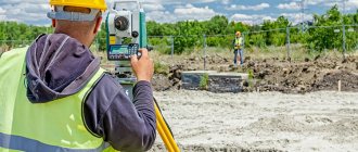
One of the areas of application of the results of geodetic work is construction. Industrial, civil facilities, administrative buildings, private houses - not a single construction project can be erected without the use of geodesy, on the accuracy and completeness of which both the service life of buildings and their functionality will depend.
Types of filming
- Topographical – used to create a digital model of the site, for planning vertical buildings and designing landscape design. The heights of some points over others, the distance between them, angles are measured, the sizes of buildings, above-ground and underground networks, streets with roads and sidewalks, and green spaces are noted.
- Executive – a set of surveys aimed at comparing actual data on an object with initial information. Surveying is carried out at the time of delivery of the finished object, but this service can also be ordered during the construction process to detect violations of building codes.
- Facade – photography of the external surface of a building to determine the coordinates of the structure, the dimensions of the facade of the structure as a whole and its individual parts. Photography is in demand during the construction and reconstruction of structures, when determining the size and area of buildings, when drawing up estimates for the restoration of houses of historical significance, and when conducting construction expertise.
- Vertical - leveling, used in geodesy when considering terrain features, studies the excess of some points over others and identifying the same heights. Based on the results, the maximum and minimum height of the site, slope, and isolines with identical elevation data are determined. Vertical surveying is necessary to identify the place on the site where the building will be most stable, as well as to clarify the slope angle of the sewer or water supply route.
- Horizontal - for tracing the contours of buildings, longitudinal sections or non-standard shapes.
Price
from 12,000 rubles
Order
How is the site location determined?
Let's look at the most common method, which is followed by 90% of cadastral engineers.
First of all, it is necessary to determine the coordinates of the survey points of the tacheometric traverse (i.e., the points on which the device stands). How to do it? To lay out and equalize the course, you need at least 2 points with known coordinates (it is more correct to use at least 3 points to eliminate errors). There are 2 types of items:
1) Points of the state geodetic network (GGS). These can be wall, ground benchmarks, geodetic pyramids, etc. There are quite a lot of such points in Moscow and they are constantly updated. In the Moscow region and beyond, the situation is much worse. The density of points reaches 1 per several square kilometers.
2) In case of inconvenient location or shortage of GGS points, GPS coordination is used. Read more here. That is, they determine the location of the starting points (this could be a fence pipe, a concrete dowel, reinforcement, etc.) - a temporary geodetic support.
A polygonometric path is laid between the control points, measuring at the station the angles and distances to the points and between the tripods. At the same time, they coordinate boundary signs and other terrain objects (if necessary). After field work, the measurements are adjusted using specialized programs and the coordinates of all measured objects, including the boundaries of the site, are determined.
Now, knowing how geodetic work is carried out during land surveying, you will have a clearer idea of what cadastral engineers will do on your land plot.
Prices of our services
Stages of work
- Preparatory. Collection of archival data about the land plot, review of technical specifications and documents submitted by the client. Development and coordination, approval of the work plan.
- Field. Before starting filming work, specialists carry out the following actions:
- A theodolite traverse is laid from the nearest points marked with benchmarks to a plot of land. If your work uses GPS equipment, then this step is skipped.
- One or more places on the site are selected from which the surveyor can observe the maximum number of desired points and carry out surveys. If there are several stations, then they should visually communicate with each other.
- By means of laser or optical centering, a total station or other device is installed, located directly above the station.
- An outline is drawn up - a visual diagram of the allotment, on which all existing objects and their characteristics are indicated on a certain scale. During the measurement work, the surveyor usually makes corrections.
- A geodetic survey of the land plot is carried out, as well as additional measurements - lines that were not visible from the station, underground communications, heights of buildings and green spaces.
- Cameral. Reviewing the results of field work, drawing plans, diagrams, projects, etc.
We will answer any of your questions! Call!
8
How much an engineering and geodetic survey of a site will cost depends on the type, complexity and urgency of the work, the location and area of the site, and the type of object.
will carry out professional geodesy of sites and geological surveys in Moscow and the Moscow region in a short time, at a high level of quality and at competitive prices. You can order a full range of work or individual services from us. You can ask questions, find out the cost, or submit an application by calling +7-495-135-15-75.
What is the object of measurement?
Let's move on directly to geodetic work. To survey a land plot, it is necessary to determine the location of its boundaries. Or its future boundaries. In fact, there are 2 options when taking measurements, regardless of the type of land survey (section, redistribution, clarification, etc.):
1) When a plot of land has certain boundaries, represented by a fence, a wall of a house, or simply pegs. In this case, surveyors determine the coordinates of the turning points of the border for subsequent drawing on the boundary plan. Accordingly, the boundaries will follow the agreed fences, walls or pegs. It is important to understand that if the boundary of the site runs inside a building (usually when dividing a house), then engineers need to know its layout (according to the technical passport) or measure it themselves. This is necessary to delimit the land plot under the house.
2) When on the ground the Customer cannot determine the exact boundaries of the site. This happens for various reasons - the destruction of the fence, or if it never existed at all, and the land was allocated. When dividing a plot - if you need, for example, to divide the plot into several parts in accordance with the shares of the owners. Without accurate measurements, it will not be possible to correctly divide the area. If there are no boundaries, cadastral engineers take measurements of all nearby significant objects (forest boundaries, fences, buildings, etc.), enter all the data into specialized programs and display everything graphically. Next, cadastral information for the work site (KPT) is used and the owner/s of the site are invited. And on the resulting digital plan it will be possible to plot the boundaries of the site. That is, to demarcate in desk conditions, guided by the data of the Customer and the real estate cadastre.
In this case, the land plot will have boundaries, as it were, “virtually”. That is, based on the boundary plan, it will be registered in the cadastral register, but on the ground the boundaries of the site will be unknown. To restore them using cadastral data, it is often necessary to again resort to the services of a cadastral engineer and remove the boundaries of the land plot. This is a separate service that is not included in the land surveying procedure.
What is geodetic work
An important component of design and preparatory work is geodesy. It is necessary in the process of land management
With its help, the customer receives quite useful information regarding the situation on the site, namely:
- relief data (accuracy and relevance are ensured);
- all kinds of design options.
The main tasks of geodesy:
- work with design materials;
- identifying the location of the main axes of object boundaries on the ground;
- adherence to the project (compliance of design requirements with reality);
- identifying the slightest discrepancies with the plan;
- working with information about the deformation of the foundations of building bodies (many factors influence).
What is executive photography?
Geodetic executive survey is divided into the following types.
- Interim , is carried out throughout the entire cycle of construction and installation work and confirms the accuracy and quality of the construction and installation work performed and is an integral part of the as-built documentation.
- Final , completes the construction process, records the actual geometry of the object and its location on the ground, and serves as the basis for making changes to topographic maps of the area.
Executive shootings are:
- The object as a whole allows you to determine its location with details of all communications (wells, cables...), buildings, access roads, etc. More often used by designers, based on the data obtained, a digital terrain model (DTM) is compiled, on which the project is designed and developed.
- Underground and overhead communications, their presence, direction of passage, connections, intersections, additional network elements are examined. This makes it possible to protect highways from damage during construction, as well as to use them for the needs of a given facility.
- Excavation pits are carried out after excavation of the soil and its cleaning, the position of the axes, the marks of the upper and lower points are determined, and the volume of excavated soil is calculated for further foundation work.
- Column-shaped structures, deviations of vertical structures, walls, power lines, masts, etc. are monitored.
- Longitudinal and transverse profiles of roads and railways, the geometric and altitude position of the embankment, as well as its structural elements (culverts, filter embankments, etc.) are controlled.
Each stage of construction ends with a control survey and execution of the as-built plan.
Carrying out geodetic as-built surveys in construction makes it possible to ensure technological control at each stage of construction, which contributes to the reliability of the structure under construction and its safe further operation.
Also on the site there are many examples of execution of executive diagrams for various structural elements and structures, which can be downloaded both in PDF format and in DWG development format.
Kinds
Current as-built surveys consistently display the results of the construction process of a building or structure. They begin with the foundation pit, and end with floors and roofing for ordinary buildings, and various types of technological equipment that will be placed - for industrial buildings. Based on the results of these surveys, builders receive data that makes it possible to adjust the work performed at any stage and ensure the quality of installation of all prefabricated structures. Particularly close attention is paid to those elements that cannot be measured after construction due to inaccessibility (all structures that will be covered with soil, concreted, etc.)
The final as-built survey is done for the entire facility in the complex and is used to solve the problems of its subsequent operation, as well as possible reconstruction or expansion. During this survey, collected materials from previous current surveys are used, and in addition - mandatory surveys of the vertical layout, transport networks, communications (both underground and aboveground), and landscaping elements.
What it is
The definition of the science of geodesy is the study of the earth's crust, its structure, surface, as well as any changes associated with it. Geodesy has a close connection with such sciences as mathematics and physics. It is geodesy that helps specialists transfer the coordinate system to the surface and model on a real scale, create geodetic networks, and determine the necessary points.
It is customary to distinguish the following stages of work:
- preparatory;
- field;
- desk.
The first stage is intended to study existing documentation that is directly related to the territory. Here, in the future, it is assumed that the planned goals will be realized and carefully designed objects will be erected. Preparation time frames will depend on the size of the facility and the locality in which the research is being conducted.
The engineering and geodetic process falls on the field stage. During this period, all work is associated with direct reference and removal of rocks. Based on the measurements, a topo map is drawn up to scale. The scale of the map is determined by the assigned tasks. So, if the task is to study the area as accurately as possible and give the most complete description of the rock on which construction is planned, then a three-dimensional topographic map is drawn up.
Graphs can be drawn up in the form of drawings, or can be recorded in digital media.
Geodesy of the land plot ends with the desk stage. The completion of this stage is the preparation of the most detailed report on the actions taken and the results obtained. The document contains catalogs of coordinates and heights, recording the location of an altitude geodetic network or several networks schematically. This stage is considered final, but no less important, since it is at the end that the information received is summarized and decisions are made.
Engineering and geodetic surveys
Engineering and geodetic surveys for construction provide topographic and geodetic materials and data on the situation and terrain, existing buildings and structures (ground, underground and above-ground), planning elements necessary for a comprehensive assessment of the natural and man-made conditions of the construction area and justification for design and construction and operation of facilities.
Topographic surveys are usually carried out at a standard scale of 1:100; 1:200; 1:500; 1:1000; . and is a common and popular type of work as part of engineering and geodetic surveys.
The most popular area of engineering surveys is construction. In this case, engineering surveys represent a whole complex of works, which includes relief analysis and various geoforecasts - in order to make construction economically and technically feasible. Engineering and geodetic surveys make it possible to calculate the initial data for analyzing the location of the object and economically and technically feasible solutions for construction.
Engineering surveys as a result of the work provide topographic and geodetic materials and information about existing buildings and relief elements.
Topographic and geodetic works (engineering and geodetic surveys) are divided into three main stages of implementation:
1. The preparatory stage of topographic and geodetic work is carried out with the aim of:
- obtaining technical specifications and preparing contractual documentation;
- collection and analysis of materials for a given territory about previously completed geodetic work (survey networks, topographic surveys, etc.);
- preparation of a program of topographic and geodetic work taking into account the requirements of the Customer’s technical specifications;
- obtaining permits (registration) for topographic and geodetic works.
2. The field stage is carried out with the aim of:
- reconnaissance surveys of the territory;
- performing a complex of field work, consisting of: creation (development) of geodetic support networks, including special-purpose geodetic networks; creation of plan-height surveying geodetic networks; topographic survey, including survey of underground and above-ground structures.
- performing the necessary amount of computational and other work carried out for preliminary processing of the received materials and data in order to ensure control of their quality, accuracy and completeness.
3. The desk stage is performed with the aim of:
- drawing up (updating) topographic plans (drawing up a geobase) - for the final processing of field materials and data, assessing the accuracy of the results obtained in the process of engineering and geodetic surveys;
- coordination of communications marked on topographic plans (power lines, communication lines, main pipelines, etc. - if any) with organizations that supervise these objects; if necessary, to make changes to topographic plans;
- compilation and delivery to the Customer of a technical report containing the necessary attachments based on the results of the work performed (topographic and geodetic work) and originals of engineering and topographic plans (in graphical and digital form).
Large-scale topographic survey or topography of areas of areal and linear objects is carried out by surveyors using modern Topcon and Trimble electronic total stations, Trimble satellite GPS equipment and Leica Disto laser tape measures. In their work, our surveyors use modern technologies, including the use of field coding of survey objects, which allows minimizing the time for performing topographic survey work and subsequent office processing of topographic survey materials, which in turn significantly increases the productivity of work.
Our surveyors search for underground utilities using a highly sensitive route finder.
Geodetic support of construction
The complex of engineering and geodetic works provides for geodetic support at all stages of construction and includes the following main types of work:
- Creation of a geodetic basis for the object;
- Taking the project to scale;
- Carrying out control geodetic surveys, drawing up executive plans;
- Maintaining executive documentation. Control and acceptance of as-built documentation of subcontractors;
Geodetic basis of the object
The main purpose of the points of the geodetic basis is to secure a single coordinate basis of the object on the ground in order to ensure geometric compliance of the objects under construction (passages, communications, buildings, landscaping elements, etc.) with the project. The use of geodetic basis points as starting points when carrying out all types of geodetic work at a site will ensure the compilation of all documents related to construction in a single coordinate system, which is necessary for the presentation of as-built documentation to regulatory authorities and the operating organization.
Bringing the project to life
It is planned to carry out in situ the main axes of buildings and structures, axes of passages, routes of underground utilities, and landscaping elements. At this stage, it is planned to gradually distribute the geodetic basis to the construction zone, secure the obtained points with temporary geodetic points, take out and secure the above objects on the ground, and draw up as-built layout diagrams. The functions of control and acceptance of alignment work performed by geodetic services of subcontracting organizations are also provided.
Carrying out control geodetic surveys
Control geodetic surveys of buildings, structures, and utility lines are planned to be carried out as construction work progresses in order to monitor the correct implementation of the project and draw up reliable as-built documentation. Particular attention is planned to be paid to geodetic surveying of underground communications in open trenches, which is necessary for their accurate display on as-built drawings.
Maintaining the executive master plan
The results of all types of control geodetic surveys are supposed to be displayed on the executive master plan, which is drawn up as construction work progresses and reflects the actual state of the object.
The phased implementation of the executive master plan will allow for timely and high-quality preparation of executive documentation for the facility as a whole.
Tracing Linear Features
The need to trace linear objects most often arises when designing large routes of utility networks: gas pipelines, water pipelines, sewer systems, communication lines. This is a very labor-intensive and complex work, which consists of preliminary selection of competitive route options, coordination of its location, setting out the axis in situ and fixing the main points of the route. This type of survey involves a full range of work that is carried out to select the most optimal position of a linear object in a certain area.
When tracing, route aerial photography, horizontal-altitude geodetic reference, field and office interpretation of aerial photographs are carried out. Large-scale engineering topographic surveys are carried out at the locations of route facilities, drains, ravines, roads, underground communications and other various obstacles. Depending on the natural conditions, the type of territory and the unique characteristics of the route, the width of the survey strip is set, which is usually about 200-300 m.
The result of topographic and geodetic work is the drawing up of a situational plan of the route strip, an engineering and topographic plan for the intersections of the route and its complex sections, as well as a complete description of the longitudinal and transverse profile at all plus and picket points. After the alignment and final approval of the route option takes place, the route axis is taken out into nature, with alignment points, turning angles, benchmarks and other main objects being secured. Upon completion of the work, an executive survey is carried out to check the quality of all construction and excavation work performed.
Satellite communications and modern equipment, as well as software, allow field teams to carry out work in almost any conditions, as well as quickly transfer materials for processing to company offices.