Home / Land, dacha, construction / Documents and legislation / Land plot / Land surveying
Back
Published: 01/10/2018
Reading time: 5 min
0
1235
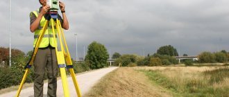
In order for a land plot to pass state registration and be recognized as property, it is necessary to carry out land surveying. When surveying a site, the coordinates of the points that determine its position on the ground are determined, and its area is estimated. When determining these site parameters, it is necessary to carry out geodetic measurements. All measurements are characterized by their accuracy and error.
- Characteristic points
- Accuracy and error
- Expertise during survey control
The procedure for cadastral work, which includes land surveying, is determined by Law No. 221-FZ “On the State Cadastre”. Issues related to the accuracy and error of measurements when land surveying are considered in Order of the Ministry of Economic Development No. 518 dated 08/12/12 “Requirements for accuracy and methods for assessing land boundaries” and in the “Methodological guidelines” dedicated to land surveying (letter from Roszemkadastre dated 04/18/03 ).
Error in land surveying: reasons, norms, legal consequences
The tendency that one mistake can lead to three others in the future has become the norm within the framework of modern land management, at the same time provoking psychosis among the population when the landowner lost confidence in the legality of his right and, in general, that the existing plot really belongs to him.
The notorious human factor is to blame, when either the owners themselves are unscrupulous in complying with all procedures related to land ownership, or the engineer conducting the measurements, due to laziness or lack of professionalism, made a number of critical errors. The result of both situations is a land dispute and the risk of alienation of part of the land, as well as termination of property rights.
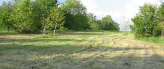
Any land ownership begins with a simple technical procedure consisting of a complex of geodetic and engineering work called land surveying. The result is a documentary and practical determination of the shape of the site, its boundaries and position on the ground.
Errors during this work are the cause-and-effect basis for future disputes, and sometimes disastrous legal consequences for the potential owner.
Thus, in land surveying methods and land legislation there is such a term as permissible error. The latter determines the size of the limiting values of the discrepancy between actual measurements and their practical expression, which, in fact, are not critical for users and owners.
Permissible error when surveying land plots
Cartometric. Accuracy of the planned position of points depending on the scale of the plan.
| No. | Plan scale | M. (root mean square error of the point position relative to the nearest GGS point) (m.), (with a plan accuracy of 0.4 mm.) | Limit error of point position (m.) |
| 1:500 | 0.2 | 0.4 | |
| 1:1000 | 0.4 | 0.8 | |
| 1:2000 | 0.8 | 1.6 | |
| 1:5000 | 2.0 | 4.0 | |
| 1:10000 | 4.0 | 8.0 |
The cartometric surveying method has accuracy restrictions on the standard accuracy of surveying land management objects. For example, for lands in intersettlement areas, a plan scale of 1:10000 is applied. Using them, you can delineate, or take coordinates from the plan of a contour point, only with an accuracy of M = 4.0 m. Comparing with the standard accuracy of surveying land management objects by land gradations, we establish that it is possible to demarcate a land plot using the cartometric method only on forest fund lands, water fund lands , reserve lands, where M = 5.0
3. Photogrammetric. Depending on the type and quality of aerial photographs, the photogrammetric method makes it possible to increase the accuracy of the cartometric method by up to 30%. Requires the availability of aerial photographic materials, technical means for condensing photo triangulation and obtaining digital information on survey objects. Innovative technologies make it possible to obtain an accuracy of 0.1 mm in an image of the appropriate scale (processing of digital aerial photographs and digital images obtained from unmanned aerial vehicles).
22. Requirements for establishing the boundaries of land plots and their registration on the ground. Installation of boundary signs along the boundaries of land plots.
The establishment and consolidation of boundaries on the ground is carried out when citizens and legal entities receive new land, when buying and selling, bartering, donating all or part of the land, at the request of citizens and legal entities, if documents certifying their rights to land uch-k, were issued without establishing and securing boundaries on the ground.
Restoration of the boundaries of a land plot is carried out in the presence of boundary disputes, as well as at the request of citizens and legal entities in the event of complete or partial loss of boundary signs and other signs of the boundaries of their land plots.
Restoring land boundaries - finding the location of lost boundary markers, fixing them in nature, control measurements of angles and line measures, calculating the coordinates of boundary markers and drawing up technical documentation.
Land surveying is carried out for the purpose of indisputably determining and identifying in situ (on the ground) the position of the boundaries of land units, determined on planning and cartographic materials when drawing up projects for the formation of new and streamlining existing land objects and the formation of land uses, as well as urban land surveying projects .
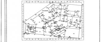
Land surveying is carried out on the basis of land plots and urban planning documentation. The graphic part indicates the design boundaries, boundary signs of land plots and the initial geodetic data necessary to determine the coordinates of the boundaries of land plots. Land surveying is carried out using geodetic and aerial photo-geodetic methods, ensuring the necessary accuracy in determining the coordinates of the boundaries and size of land parcels.
The boundaries of land plots in nature (on the ground) are fixed with boundary signs. It is allowed to fix the boundaries of land plots without installing boundary signs if they coincide with natural and artificial linear structures and boundaries (rivers, streams, forest belts, roads, fences, and other linear structures and boundaries).
The boundaries of a land plot, fixed in nature (on the ground) with signs, or coinciding with natural or artificial structures and boundaries, are recognized as indisputable and are protected by the state.
The delineation of land management objects has not only technical, but also legal content, which is due to the following reasons: - the establishment of boundaries is always carried out in accordance with land management, on the basis of decisions of authorities and in accordance with current legislation; - a certain procedure is followed, since boundaries are necessarily agreed upon with land management areas, which is confirmed by the approval protocol; -a drawing of the location of boundaries indicating the measures of lines, bearings and other data is in the land management file for issuing certificates of land ownership; -borders drawn out in nature, fixed on the ground with boundary signs, confirm ownership of the land (zv, zp-nii) and are protected by law.
Boundary signs are placed at all turning points of the land boundary. The boundaries of land plots passing through living tracts are fixed with boundary signs only at the junctions with upland boundaries.
In accordance with clause 4.6. Instructions for land surveying use wooden stakes 75-80 cm high, 5-7 cm in diameter, iron pins and pipes driven into the ground 0.4-0.6 m as boundary markers. Boundary markers on an uncoated surface are dug into a round ditch with an internal diameter of 0.8 m, depth 0.2 m and width at the bottom 0.2 m.
The establishment of land boundaries is carried out on the ground in the presence of a representative of the district, city (village) or rural administration, owners, landowners or land users of the demarcated and adjacent land plots, or their representatives, whose powers are certified by powers of attorney issued in the prescribed manner.
The results of establishing and approving boundaries are formalized in an act signed by the owners, landowners, land users of the demarcated and adjacent land plots, the city (village) or rural administration and the work contractor. The act is approved by the territorial body of Roszemkadastre.
The area of land is calculated mainly by analytical methods using the coordinates of boundary markers obtained by geodetic and photogrammetric methods. Based on the results of land surveying work, a drawing of the boundaries of the land plot is drawn up on a scale equal to or larger than the scale of the base cadastral map (plan). A drawing of the boundaries of the land plot is drawn up by the contractor and approved by the head (deputy) of the territorial body of Rosnedvizhimost.
23. Accuracy of land surveying and control over its implementation
The delineation of land plots for various purposes is carried out with an accuracy not lower than the accuracy given in Table 1.
Date added: 2015-09-20; | Copyright infringement
Recommended content:
Related information:
Search on the site:
Causes and technical features of the error
Error is typical for any mathematical and technical measurements. Thus, the difficulty of land surveying lies in the fact that it is almost impossible to absolutely accurately transfer the boundaries from the documentation to the terrain, as a result of which errors are allowed.
But its value or indicator should be minimal - not critical for the user, that is, it should not actually affect the maximum useful component of the land plot, its practical value and liquidity.
Consideration of this point requires the use of a number of purely technical terms. The boundaries are determined between characteristic corner points relative to the survey reference points. They are scattered over one kilometer square at 2-4 points, coordinated in the GPS system. The difference between the real coordinates of the corner points and the coordinates obtained as a result of engineering measurements is the error.
It is formed as a result of the action:
- Human errors.
- Inaccuracies in the operation of devices.
- Weather features.
- Nuances of the terrain.
In calculations, the main indicator and starting point of all error measurements is the survey justification point. This point is where the engineer installs the measuring instruments. In this case, uneven landscapes and engineer errors can lead to displacement. The measuring device itself has a certain amount of error. Thus, in order to reduce the magnitude of the error, measurements are made multiple times.
Maximum permissible error in determining the tooth area
The value of the mean square error in the location of characteristic points is taken to be equal to the value of the mean square error in the location of characteristic points used for calculations. 14. If adjacent land plots have different requirements for the accuracy of determining the coordinates of their characteristic points, then the common characteristic points of the boundaries of the land plots are determined with an accuracy corresponding to the higher accuracy of determining the coordinates of the characteristic points of the boundaries of the land plot. 15.
At the request of the customer, the contract for cadastral work may provide for determining the location of characteristic points with higher accuracy than established by these requirements. In this case, the determination of the coordinates of characteristic points is carried out with the accuracy specified in the contract. * Part 7 of Article 38 of the Federal Law of July 24, 2007
Legislative framework
In addition to technical nuances, the term also has a legal basis, which establishes the amount of permissible error.
This point is regulated:
- 218-FZ (clause 13, article 22);
- letters of the Ministry of Economic Development No. 518 and 582 dated 08.12 and 12.09;
- 90 order of the Ministry of Economic Development.
The latest document defines the calculation formulas for the permissible error, as well as methods for determining corner points and their coordinates:
- Polygonometric.
- Photographic.
- Satellite methods.
- Methods of analysis.
- Taking photographs.
- Cartography.
The legislative framework
| Number | Description |
| №518 | “On the requirements for accuracy and methods for determining the coordinates of characteristic points of the boundaries of a land plot, as well as the contour of a building, structure or unfinished construction site on a land plot” |
| Number | Description |
| №221 | “On the state real estate cadastre” |
The maximum permissible error when establishing the boundaries and area of a land plot is a strictly fixed value.
Find out how the geodetic basis of land surveying is carried out in the article: geodetic work when surveying land plots.
If you are interested in when a land survey map is required, read here.
If you want to know why you need land surveying, look here.
It is established in accordance with the categories of land located within the city or in rural areas.
To calculate the error, a formula approved by regulatory acts and orders of the Ministry of Economic Development is used.
Attention!
- Due to frequent changes in legislation, information sometimes becomes outdated faster than we can update it on the website.
- All cases are very individual and depend on many factors. Basic information does not guarantee a solution to your specific problems.
That's why FREE expert consultants work for you around the clock!
- via the form (below), or via online chat
- Call the hotline:
APPLICATIONS AND CALLS ARE ACCEPTED 24/7 and 7 days a week.
The order, which determines possible deviations during land surveying, was registered under N 26340, dated December 25, 2012. It carries requirements for accuracy, measurement methods when marking the PTZ and the boundaries of all existing structures.
Federal Law 218 stipulates acceptable intervals. The logical result of determining the boundaries of the land plot according to this Federal Law is the development of a boundary plan. The draft states that the location of the land plot lines is determined by identifying the HT coordinates of such boundaries, which makes it possible to determine the allotment lines and divide them.
The demarcation of land plots is regulated by law. He also establishes how much error is allowed. Part 13 of Article 22 of Law No. 218 states that all errors in measuring the coordinates of key points and the methods by which measurements are made, as well as calculation formulas, are reflected in Order No. 90 of the Ministry of Economic Development.
The following methods are legally permitted:
- satellite;
- analytical;
- cartometric;
- photographic;
- polygonometric.
Also, all technical details are regulated by letters of the Ministry of Economic Development No. 518 and No. 582.
All necessary operations and everything that is needed to carry them out are legally enshrined, and not just the whims of the land surveyor or the organization whose services it was decided to use.
Error limits
The minimum sizes of permissible errors are established at the regional and municipal levels. For the majority of subjects, divergence norms are established based on the purpose of the land:
- Land for individual housing construction - 300 square meters.
- In dacha construction - 600 square meters.
- KFK land – 600 square meters.
- Land of private farms - private household plots - 400 square meters.
- Vegetable garden lands – 400 sq.m.
- For the construction of garages - no more than 18 square meters.
- Land for organizing street trading - no more than 5 sq.m.
At the same time, it should be noted that the norms of permissible error during land surveying also depend on the functional purpose of the land, which consists of the following values:
- Areas within populated areas – up to 10 cm.
- Private household plots – 20 cm.
- Agricultural land – 2.5 m.
- Lands for industrial use – up to 0.5 m.
Error correction issue
The consequences of incorrect definition of boundaries and significant deviations from permissible errors lead to incorrect assessment of taxes, as well as to disputes with neighbors.
For minor errors, there is no need to re-survey.
Thus, discrepancies may arise due to technical or cadastral errors. To make corrections, you simply need to submit an application to the cadastre and cartography authorities, attaching documents reflecting the correct measurements. Naturally, repeated boundary work is carried out to identify and correct errors.