Basic Concepts
Before talking about the purpose of topographic survey, it is worth taking a closer look at its main aspects.
So, the result of topographic survey is a topographic plan. This is a detailed image of a site on a reduced scale. It is in great demand in the modern land market and its preparation is included in the list of services of any geodetic company. The topographic plan reflects all objects located on the site (and under communications) in a system of conventional signs indicating elevations and contour lines. Prepared in paper and electronic form.
Topographic surveys come in different scales. The choice of scale depends on the purpose of geodetic work. The smaller the scale, the larger the object of work and the less accurate and informative the plans. And vice versa - large-scale topoplans have high accuracy and a larger number of contours and objects are applied there, up to underground utilities and bushes. Accordingly, the larger the scale, the more expensive it will be to prepare a topoplan for an identical area.
In most cases, scales of 1:200-1:500 are used. They are most often needed for various construction works. Within its scale, a topographic survey of a land plot is carried out indicating permanent buildings, road networks, fences, underground utility outlets, lighting poles, green spaces, water bodies, etc.
Topographic surveys have a large number of types, which are characterized by different techniques, instruments used and accuracy. The use of each of them is dictated by the expediency of labor costs, the volume of work and the required accuracy.
Many owners or tenants of land plots ask the question, “Why do I need a topographic survey on my plot?” Or more specifically, “Do I need topographic survey for land surveying, or gas supply, for example?” The following are cases when you still need topographic survey.
What is topographic survey of a site
Topographic survey is the result of a complex of geodetic work, which is based on measuring the area and drawing up a plan. For this purpose, surveying instruments and specialized software are used. The final result is a topoplan or, as it is also called, a geological basis of a certain scale using approved symbols.
Purpose of topographic survey Generally, topographic survey is divided into two types: before the start of construction to create and approve design documentation and after completion of construction to calculate and identify deviations from the given project.
Main purposes:
- For construction
- Laying of utility networks
- Landscape design
- Registration of land ownership
- Obtaining a building permit
- Territory planning
- Creating a dendraplane
- Cadastral works
- Conducting engineering and geodetic surveys
Executive topographic survey is carried out after carrying out a certain type of construction, laying communication routes, and planning the territory.
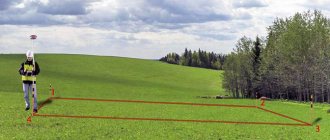
The data is used to determine how accurately the construction was carried out and what actual deviations from the design documentation were. Methods of topographic surveys Carrying out topographic surveys depends on many parameters, the purpose of the future geo-base, the area of the object and its location, accessibility. We can name the main methods that surveyors use to obtain field data (measurements).
Tacheometric - at the moment it is one of the main methods of carrying out geodetic work; when performing it, an electronic tacheometer is used, which measures angles, lengths and elevations between certain points on the ground. It refers to the most accurate type of measurement, the error that occurs during tacheometry is up to 2 mm in plan.
Satellite - GPS surveying, this type is gaining more and more popularity; to perform this type of measurement, high-precision geodetic GPS receivers are used, which are capable of calculating the location of points on the ground with an accuracy of 1-2 cm. One person is enough to perform measurements using a GPS receiver. For high-quality and accurate GPS data, you need many related things, calibration of the coordinate system, installation of base stations, and so on.
Filming using unmanned aerial vehicles or quadcopters - this method is not so widespread at the moment.
The main reason that does not allow the use of UAVs is the accuracy of the issued topoplan, about 10 cm. The advantages of aerial photography is its speed in the field; aerial photography is used mainly for large objects with an area of more than 30 hectares. The resulting scales are 1:1000 1:2000 and beyond; for the design and construction of utility networks, aerial photography is currently not fully suitable due to the many variables that can affect the quality of the produced material.
3D scanning - when using 3D scanning, a huge number of points are obtained; it is called a point cloud. The disadvantages of using it are the cost of the equipment and the complexity of its processing. 3D scanning is most often used for measurements inside buildings - premises for developing planning projects and so on. The use of a 3D scanner in the production of topographic surveys is unjustified; the high cost of the equipment and the difficulty in processing the results obtained complicate the drawing process.
Stages of work
It is divided into stages; there are several main ones, which we will discuss below:
the first stage preparatory - at this stage, information is collected about the areas of future topographic measurements, configuration range, relief shape, presence of vegetation and other infrastructure elements.
The optimal shooting method is selected to obtain a more accurate result that will correspond to the technical specifications. In this section we can include the signing of contracts, approval of technical specifications, and so on. The second is direct measurements on the ground (as they say in the field), depending on the method of implementation. A team of surveyors or a surveyor must go to the land plot to take measurements. By measurements we mean determining the coordinates of the main elements (Points): buildings, structures, roads, fences, relief elevations, collecting field data for subsequent processing on the basis of which a topographic plan will be formed. Third - After taking measurements, the data that was received in the fields needs to be processed. Field measurement data is processed using various technical and information programs that make it possible to competently and correctly draw a topographic plan of the area. This type is called deskless, it takes place remotely in the offices of geodetic companies. The end result is a topoplan in electronic form in the AutoCAD program in a certain coordinate system and scale, which is ready for printing and further development of design documentation. To the fourth and final stage we can include such types of work as the coordination of utility networks, this means the passage of services that operate communications that fall into the area of topographic survey to confirm the correctness of their application.
How is topographic survey carried out?
It all starts with the approval of the technical specifications, the purpose of this type of document is clarified, for what purposes it will serve, after the surveyors have received all the necessary information, they go to the land plot, make all the necessary measurements on the ground, then process this data and hand over the received documents to the customer.
- Measurements are made in a specific coordinate system , which is approved by the customer or other legal document. Most often, the coordinate system of the corresponding region is selected, for example MSK50, MSK36. SC implies metric coordinates of the X Y format. The Baltic system of heights is used for the elevation mark; it was adopted back in the USSR. System of heights - the zero count of which is carried out from the zero of the Kronstadt footing rod; from this mark, all the heights of the benchmarks forming the leveling network of Russia are calculated.
- The plan consists of linear point and area objects. Each of the objects is assigned its own individual symbol. Based on this, surveyors take measurements and calculate the coordinates of objects that should be indicated on the topoplan. The measurement includes determining the elevations of the relief and its configuration.
- Processing of field data - Using specialized software, coordinates are calculated to obtain characteristic points of the future topoplan.
- The diagram is drawn by substituting its own symbol for each point and connecting linear objects. All conventional signs have their own characteristic parameters. The use of signs makes the plan easy to read.
- The final stage is transferring the diagram to the AutoCAD where 1 drawing unit will correspond to one meter on the ground.
What tools are used
To carry out geodetic measurements, specialized geodetic equipment is used, which must be certified - verified for compliance with state accuracy standards. Verifications are carried out on equipment once a year, which confirms the suitability of the equipment; if the equipment has not passed verification, it cannot be used.
Basic geodetic equipment:
- Electronic total station
- GPS receiver
- Quadcopter or other aircraft
- Tool for scanning underground utilities (router)
Main scales
The scale varies from the purpose of a specific topographic survey; according to statistics, for design and survey work on an area of up to 100 hectares, a scale of 1:500 is used; it can be increased if the object is linear and its length is more than 10 km. The scale for the topoplan is selected individually based on its application; you can read about the scale and accuracy in our article.
Legislation
- GKINP (ONTA)-02-262-02 Instructions for the development of survey justification and terrain survey using global navigation satellite systems GLONASS and GPS
- GKINP-02-033-82 Instructions for topographic survey on scales 5000, 2000, 1000,500 (approved by the USSR State Administration on October 5, 1979)
- SNiP 11-02-96 Engineering surveys for construction. Basic provisions
- SP 11-104-97 Engineering and geodetic surveys for construction
- SP 11-104-97 part 2, Surveying underground utilities
- Conventional signs for topographic plans of scales 1_5000, 1_2000, 1_1000, 1_500
Get a building permit
Not all construction requires a permit. Before you begin construction, you need to find out the permitted use established for your land plot. This is indicated, for example, in the Extract from the Unified State Register or the public cadastral map.
It is worth immediately clarifying that owners of private land plots do not need to obtain permission if you are going to build non-commercial real estate. This could be a house, barn, bathhouse, etc. In some cases, notification of the start of construction will be required.
In other cases, obtaining permission is necessary. And an integral part of the work before this will be topographic survey. It is impossible to design most objects without topography.
Why do you need a topographic survey of the site?
And now, probably the most important question: why do you need a topographic survey of the site? The answer is very simple - before the start of any construction. Topographical surveying is done to determine the characteristics of a given land plot, real estate object, and based on the measurement results, projects, territory plans, security zones and much more are drawn up. Without a high-quality and accurate diagram, it will be difficult to design and place any technical structure, be it a house or ending with highways and electrical substations.
Design capital construction facilities (CCS)
Here we will talk about buildings that require a building permit.
It's no secret that to start designing it is necessary to have data on the land plot on which construction will take place. The main source document is a topographic plan or geobase. Most often the scale is 1:500, but for large industrial facilities or facilities in sparsely populated areas it is possible to use 1:1000 and 1:2000. If you connect the design of the OKS and obtaining a construction permit, then the order is as follows: first topographic survey, then design, then obtaining a permit. The design of the future building is applied to the topographic plan and is, as it were, “tied” to the boundaries of the land plot. When planning the construction of public transport systems, the passage of various communications is almost always immediately planned.
Objects and stages of geodetic topographic survey
During geo-surveying, specialists apply:
- Terrain with contour lines;
- Communications, both external and internal;
- Outlines of buildings and structures;
Development and implementation of the technical report includes:
- Technical task;
- Office work (direct creation of a topographic plan and processing of field data);
- Coordination of the correct placement of utilities with operating departments (Vodokanal, Military units, Rostelecom and others);
- Preparation of a report on the completion of work;
engineering electronic total station - Providing the customer with a report, map and site plan.
Bring up communications
If buildings on the site have already been built or you plan to install communications (gas, telephone, water supply, sewerage, etc.) from central networks along with the construction of the house, you again cannot do without a geological basis. Operating organizations (gas services, MOEK, water utility) will require a topographic plan with networks and other objects marked on it for the territory of the planned passage of communications from the tie-in to the entry point to the building. Often a situational plan is also needed. Topographic survey will also be needed when it is necessary to reconstruct communications on the site. Topographic survey for gasification of buildings is the most popular type of work today. Our specialists often prepare topographic plans for gas services, so they know exactly what to do and how to prepare it. It is the “gas workers” who often do not accept topographic plans from “third-party” organizations, preferring to send everyone to well-fed partners who do not hesitate to inflate prices.
Types of topographic survey depending on the technological process
Topographic survey can be divided into types, taking into account the equipment used during the work:
- theodolite - a complex of ground surveys designed to obtain metric data, carried out using rangefinders and a theodolite;
- stereotopographic - characterized by obtaining primary information using a stereo pair;
- compass topographic survey is carried out using equipment such as rangefinders and compass;
- mensula - performed using kipregel and mensula;
- aerial photography - allows you to obtain a photographic image using aircraft;
- digital - the process of obtaining an optical image, which is subsequently transferred to a specific medium;
- Sonar survey allows you to obtain information about the bottom of various bodies of water; it is performed by a sonar.
Improve the land plot
Landscaping means not only planting bushes and paving paths. This is a whole range of works, which includes the preparation of a topoplan, design and implementation of the plan. Landscaping is lighting, sidewalks and driveways, green spaces, water features, decorative fences, changing the terrain and much more, which is designed to make the use of the land more convenient and practical. For this purpose, large-scale plans of a scale of 1:200-1:500 are used. They are often called landscape topoplans. Their key feature is the indication of the location of all vegetation and an accurate reflection of the relief features. Landscape designers and design organizations use such plans. Even if you want to do a landscape project yourself, such a plan will help you avoid mistakes and inaccuracies. Even on a small plot of land, your imagination has room to roam, and a topographic plan will help with this.
Apply for an extension or buy municipal land
All these actions directly relate to the design of the layout of the land plot. Before allocating or selling a plot of land, a representative of a state or municipal body must have an idea of what is located on the property. This is why a layout diagram is required. In Moscow, the DGI prepares the diagram, and there is no talk about topographic survey there. But in the rest of Russia, as they say, some go to the forest, some go for firewood. And, although this is not provided for by law, the results of topographic surveys are often required to be applied to this diagram. That is, you can submit a scheme without it and insist that you are right, but if the administration believes that it is needed, it will not be possible to convince you. Topographic survey is necessary so as not to inadvertently allocate any driveway or pond as private property. After all, the cadastral map on which the location diagram is based does not always clearly reflect the realities of the area. As a result, we would like to advise you to ask the administration about the need for filming, so as not to waste time and extra money.
The future owner of the land should know
know that a topoplan can be useful, because there is a possibility of some communications passing through the site. This may make subsequent construction on it difficult or impossible. It turns out that the results of topographic surveys can influence the decision to purchase land.
Inventory communication networks
This type of topographic survey is more in demand by legal entities, in particular by balance holders of power lines, water pipelines, cables, etc. In essence, this is either executive shooting of new communications or shooting of old ones to clarify their quantity and location. According to the technical specifications, it is possible to indicate on the topoplan not only the communication itself with its height, but also adjacent objects with a given width from the axis.
Get a logging ticket
A felling ticket does not require a topographic plan as such. Because neither heights nor underground communications need to be indicated. A tree-by-tree topographic survey is required. The tree-by-tree plan will indicate all ground objects (buildings, roads, etc.) and, accordingly, trees and shrubs. All trees planned for felling or pruning are also indicated there. All this is certified by the seal of the balance holder of the territory where logging work is planned.