All articles
18865
2009-03-13
When selling real estate, a subject may encounter a technical or registry error. The presented material will tell you how to correct the error in the location of the boundaries of a land plot on the cadastral map, in which cases your participation is required and in which it is not.
Manipulations carried out with square meters and land require the preparation of an accompanying package of documents. The owner must present an extract from the Unified State Register of Real Estate . The certificate displays information about real estate, land, owner, and procedures carried out with real estate.
You can find a plot on a cadastral map, but the plot is not always displayed, which leads to a number of problems. The reason lies in a cadastral error.
What are the mistakes in the real estate cadastre and who makes them?
Errors in cadastral information can also be quite harmless in nature - such as typos, omission of some minor information, etc. And they can be a serious violation of the reliability of information about your site.
They come in two types: cadastral and technical. A separate article has been written about technical ones. We will focus on cadastral errors.
A cadastral error appears when incorrect information about a land plot is provided when registering (or making changes to) a border. That is, this is incorrect information about the location or configuration of the storage device.
Did you know:
What contribution do cadastral engineers make to the cadastral confusion?
Such errors can be made by cadastral engineers, municipal self-government bodies (authorized to issue a land plot location diagram) or judges who made a court decision with incorrect data about the site. Ultimately, the cadastral engineer issues the boundary plan, but the error may be based on incorrect “initial” data on which he relies (land plot diagram and court decision). Therefore, do not rush to blame him; first you need to understand the reasons.
Registry and technical error, what is it?
By purchasing an extract from the Unified State Register, individuals or legal entities receive information entered in the register. However, if errors were made when entering data into the Unified State Register of Rights (previously in the State Property Register - the State Real Estate Cadastre or the Unified State Register of Rights), they may be repeated in the new register. What should you pay attention to? According to the current legislation, errors in the Unified State Register are divided into two types - a technical error and a registry error.
What is a technical error?
A technical error is a clerical error, typo, grammatical or arithmetic error made by the rights registration authority when carrying out registration actions and leading to a discrepancy between the information contained in the Unified State Register of Real Estate and the information contained in the documents on the basis of which the right was registered and the object was registered in the cadastral register.
How is a technical error corrected?
A technical error is corrected by decision of the state registrar within three working days from the date of discovery of such an error in the records or receipt of an application from any interested party to correct a technical error, or on the basis of a court decision that has entered into legal force to correct a technical error in the USRN records.
What is a registry error?
A registry error is an error reproduced in the Unified State Register of Real Estate, contained in a boundary plan, technical plan, map plan of the territory or a survey report, which arose as a result of an error made by the person who performed the cadastral work, or an error contained in documents sent or submitted to the rights registration authority by others persons and (or) bodies in the order of information interaction, as well as in other order established by the Federal Law of July 13, 2015 No. 218-FZ “On State Registration of Real Estate”.
An error in the information contained in the Unified State Register of Real Estate about the location of the boundaries of land plots (the coordinates of the land plot do not correspond to the actual location of the land plot) is the most common among registry errors.
How is a registry error detected?
An error in information about the location of the boundaries of a land plot contained in the Unified State Register of Real Estate can be identified by a cadastral engineer during cadastral work.
If inconsistencies are identified in the USRN information about the location of previously established boundaries of land plots, including adjacent land plots in respect of which cadastral work is being carried out, the boundary plan must contain the conclusion of a cadastral engineer, which is drawn up in the form of a coherent text. The section provides justifications for identified errors in the location of previously established boundaries and ways to eliminate errors.
The cadastral engineer is responsible for the quality of the work performed. For entering knowingly false information, including in the boundary plan, if this action does not contain a criminal offense, the person carrying out cadastral activities bears administrative responsibility, in accordance with Part 4 of Art. 14.35 Code of Administrative Offenses of the Russian Federation.
Control over the activities of cadastral engineers in terms of their compliance with the requirements established by law is carried out by a self-regulatory organization in the field of cadastral activities, of which the corresponding cadastral engineer is a member.
How can I fix a registry error?
To correct a registry error, you must submit an application to make changes to the USRN information in connection with correcting the registry error.
Also, documents containing information necessary to correct registry errors can be received by Rosreestr in the manner of interdepartmental information interaction (without the participation of a citizen), if an error was contained in such documents. The decision to correct a registry error may also be made by the court. In all cases, the registry error is corrected by Rosreestr within 5 days after receipt of the relevant documents.
However, if the correction of a technical or registry error entails the termination, emergence or transfer of registered property rights, the situation can only be resolved in court.
Leading specialist-expert of the legal support department
Maria Sergeevna Sizova
Who corrects them and how?
Accordingly, the errors are corrected by the body or person who made them. Read about the technical error here. The procedure for correcting cadastral errors is given below.
To correct a cadastral error, the owner needs to either:
— contact a cadastral engineer to prepare a boundary plan to correct the cadastral error and clarify the boundaries of the owner and his neighbors. There is a nuance here - if your neighbors put their plots on the cadastre before 03/01/2008, then the cadastral engineer will correct both your plot and theirs in the boundary plan. If after, then only in agreement with the neighbors. If there are no disagreements with neighbors (an agreement is signed) and representatives of Rosreestr agree with the change in the boundaries of land users, then the error will be eliminated pre-trial.
- file a claim with the court if other means fail to eliminate the error.
Did YOU know: The court very often requires the conclusion of a land survey to determine the causes of a cadastral error.
The defendant can be either the cadastral chamber and the cadastral engineer (who made a mistake), or the owner of the land plot whose borders cross yours. The purpose of the claim is to make changes to the erroneous location of the boundaries of your land plot, since you cannot demand to change the information about the land plot of another owner. But again, after the court’s decision, it will be necessary, on the basis of this decision, to order the preparation of a boundary plan to correct the cadastral error. Do not forget that only cadastral engineers, and not the court, have the right to make changes to the real estate cadastre.
What it is
Since 2013, on the territory of the Russian Federation, every property, including land plots, is subject to cadastral registration. This procedure consists of systematizing and summarizing data for each object and entering it into a single database - the Unified State Register of Real Estate. To carry out cadastral registration, the owner of a plot of land must submit a boundary plan, which has the following features:
- the boundary plan is prepared by a professional specialist - a cadastral engineer who has a qualification certificate and membership in a specialized self-regulatory organization;
- registration of the boundary plan is carried out on the basis of the cadastral work carried out, during which the engineer collects information about all the characteristics of the site (area, characteristic boundary points, etc.);
- By virtue of Article 14 of Federal Law No. 218-FZ, the submission of a boundary plan is one of the grounds for cadastral registration and registration of a land plot in the Rosreestr service.
Despite the high qualifications of cadastral engineers, errors may be made in the process of performing cadastral work and drawing up a boundary plan. If the distorted content of the boundary plan was transferred to the Unified State Register of Real Estate during cadastral registration, this violation is recognized as a cadastral error and must be corrected in order for reliable information to be entered into the register.
How has the correction of cadastral errors changed since 2017?
Also on the topic: Violation and protection of the rights of the owner of a land plot
Since January 2020, a new Federal Law No. 218-FZ has come into force, which regulates legal relations related to cadastral registration and registration of real estate rights. Article 61 of this regulatory legal act regulates the grounds and procedure for correcting errors in the information of the Unified State Register of Real Estate. With the adoption of Federal Law No. 218-FZ, the concept of a registry error was used, which in its legal content fully corresponds to a cadastral error.
How to identify a cadastral error on your land plot?
Identifying a cadastral error is not so easy. Let us remind you that a cadastral error can only affect land plots included in cadastral registration. Below are options for detecting a cadastral error, that is, an error in the location of your site.
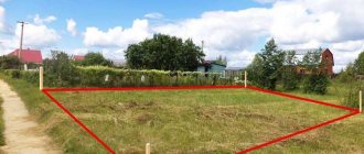
-The easiest way is to find your plot on a public cadastral map. Gross inaccuracy will be visible to the naked eye in the photograph.
-It’s more difficult and more expensive to call a cadastral engineer and check the compliance of the actual and cadastral boundaries. This is the so-called outlining of boundaries. But it’s worth doing if for some reason you doubt your limits and you need accurate measurements. After all, this procedure is not cheap. If the boundaries of your land plot do not correspond to the cadastre, it means an error has crept in or a neighbor has slowly moved the fence in the winter (and this has happened in our practice).
-Most often you do not even suspect that the cadastral information about your plot is incorrect. Your neighbor will notify you about this if he registers the plot later than you and asks you to agree on the border and correct the cadastral error.
What is a cadastral error in the location of the boundaries of a land plot?
In legislation, the moment of a possible error in entering data into the cadastral register is reflected in Federal Law No. 221 on the State Property Committee. At the same time, the document indicates ways to eliminate inaccuracies in information about the boundaries of land plots.
As a rule, the most common mistake when entering data into the Unified State Register of Real Estate is incorrectly determining the actual location of the boundaries of land plots. Understand that this error occurs due to incorrect fixation of the coordinates of the points changing the direction of the boundaries of the site. After registration work has been carried out in relation to a plot of land, erroneous data is entered into the cadastral register.
After such a process, duplication of distorted information occurs during the further use and application of data on the boundaries of the site.
The following persons can record and enter incorrect information into the cadastre:
- An authorized employee of the land registration authorities;
- An engineer who draws up a cadastral plan for a plot of land;
- A specialist who takes photographs of the area and carries out geodetic surveys.
Understand that the earlier incorrect data was entered into the cadastral register in relation to specific plots of land, the more difficult it is to identify the essence of the error and correct the information published in relation to the plot.
The consequences of incorrect work by geodetic and cadastral engineers are the overlap of land plots, which causes disputes between owners and violates their rights.
Explore the most common circumstances that cause errors regarding KM boundaries:
- Using faulty equipment to carry out work to coordinate turning points of land boundaries;
- The use of incorrect data from the cadastral register in relation to the territory, which is used to consolidate the site plan with the terrain;
- Negligent attitude of the cadastral engineer to the calculation of data, which is then used in the work to create a plan for the location of the boundaries of the land plot;
- Significant errors that are not taken into account when designing boundaries in situ, which changes the configuration of the site and its total area.
Serious difficulties arise if you do not eliminate the problem with inaccuracies in determining the boundaries of the land plot before registration with the cadastral register. All agreements regarding land plots with incorrect boundaries can be declared void on the basis of Federal Law No. 122. Any incorrect information in the data about a plot of land is grounds for termination of property registration for a calendar month.
If the data is not corrected, then after 30 days the transaction may be considered imperfect with all the ensuing legal consequences for the owner of the property and the acquirer of the land.
Time frame for correcting a cadastral error
It is difficult to name a specific time, because in order to correct them, it is necessary either to prepare a boundary plan (in case of a peaceful solution) or prepare a land management examination (in case of a judicial decision). Accordingly, to the time frame for Rosreestr’s consideration of an application to correct an error, it is necessary to add time for preparing an interplan or conducting judicial activities. On average, a boundary plan is prepared in 2 weeks or less, and the trial can last for several years.
The cadastral chamber (upon submission of all documents) must make a decision to correct the cadastral error within 18 working days or 30 working days (if it is necessary to obtain additional information from other departments in the order of information interaction).
How to fix the error?
The legislation allows you to correct an error in the Real Estate Register using one of three options:
- Form a new boundary plan in a situation where the neighbors have come to an understanding and are ready to fix new exact boundaries of the plots. Then a cadastral engineer is invited, the whole range of work is carried out and an act of coordination of boundaries with all owners of adjacent lands is attached to the boundary plan.
Correction of an error in accounting for a construction project occurs on the basis of a new technical construction plan.
- As part of information interaction with other departments, if cadastral registration was carried out by transferring information through interdepartmental exchange.
- Based on a court decision to correct the error. This option is used if the parties are unwilling to resolve the issue of clarifying the boundaries of the plots on a voluntary basis.
If a registration error is detected, the registration authority makes a decision on the need to eliminate it and sends a copy of it to the copyright holder of the site. The owner is given 6 months to carry out the necessary work and make clarifications, after which Rosreestr has the right to unilaterally correct information about the boundaries and area of the allotment in the Unified State Register. This is done on the basis of information contained in title documents superimposed on a cartographic basis. In this case, a deviation of the area of a plot of land is permissible by no more than 5 percent from the previously established value.
Please note that in order to correct a registration error in the Unified Register, the owner must resort to the help of a cadastral engineer, since new information will be entered on the basis of a newly formed boundary or technical plan. Documents must be attached to it confirming the existence of this error and a section must be filled in where its presence is substantiated.
Correction time
Correction of the register inaccuracy occurs based on the decision of the registration authority within 5 working days from the date of receipt of the above documents. If the error is corrected on the basis of a court decision, then the period is set from the date it enters into legal force.
When eliminating a technical error in the Rosreestr database (discovered by the registration authority, based on an application from an interested party or a court decision to correct a technical error), the following procedure exists:
- the registration authority makes a change to the Unified State Register within three working days;
- The registration authority is obliged to notify the owners of land plots for which a technical error has been corrected within three working days from the date of the changes.
A registration error may be corrected in this manner if this action does not entail the transfer, termination or creation of a registered right in respect of the property. Otherwise, changing the data in the Unified State Register is possible only by court decision.
An example of drawing up a boundary plan to correct a cadastral error
To understand what a boundary plan looks like and what is included in it, we provide a sample. Of course, the appearance and filling will change somewhat, especially in the conclusion of the cadastral engineer. After all, a cadastral error can be of various kinds, and its description is included in the conclusion. Unfortunately, the legislative bodies cannot find the “correct” type of boundary plan in their opinion and are churning out orders and additions to orders, resolutions and various versions of laws. This leads to the fact that “yesterday’s” view and filling of the interplane “today” is no longer relevant. The essence of the document, in principle, has not changed since the time of “land management”. At this point, the boundary plan should look like the one on the slider on the left ⇐. We'll keep you posted on what it will look like afterwards.
It is worth adding that recently boundary plans have been submitted to the Rosreestr authority in electronic form, and in an encrypted .XML file. And the customer does not even have the opportunity to familiarize himself with the paper version of what he has to give to the cadastral chamber. Therefore, we recommend that you ask the cadastral engineer for a paper version of the interplan, although this is not required by state accounting authorities.
Cost of drawing up a boundary plan to correct a cadastral error
When ordering a boundary plan to correct a cadastral error, you should understand that there may be many options. Most often, the correction comes down to clarifying the boundaries of a land plot, or several at once (after all, an error can directly affect a large number of neighboring plots). Therefore, you can look at the pricing policy to clarify the boundaries.
Prices again depend on the need for field measurements. In some cases, you can do without a field survey. Without visiting the site, the cost will be 30% cheaper. But it should be understood that preparing a boundary plan may not solve the problem in case of disagreements with representatives of the cadastral chamber. In this case, you will be subject to legal costs.
Prices of our services
Mistake 5. False boundaries
The owner of plot No. 2 is sure that his plot is displayed incorrectly on the cadastral map. It claims a large area. Perhaps he even surrounded the area with a fence, and none of the neighbors make any complaints
. There is no technical or registry error in the USRN.
How to fix:
The public map displays everything correctly.
We are faced with land squatting
.
It happens that, using the adjacent territory for a long time, the owners automatically attribute to themselves the “extra” acres. This is illegal and is subject to administrative prosecution under Art
.
7.1 Code of Administrative Offenses of the Russian Federation. However, if the owner of plot No. 2 is confident that he is right, he will have to substantiate his claims in court. In essence, we are talking about the legalization of squatting and the acquisition of another piece of real estate
.
Set the current owner
disputed area.
Often this is a rural settlement, an urban district
. As a starting point we use Art. 11.7 of the Land Code of the Russian Federation “Redistribution of land plots”;
Be prepared for land surveying
and registration of the site for cadastral registration;
Document your reasons
your claims and contact the current owner pre-trial. Be prepared to justify your position in court;
If there is no confirmation
possession use Art. 234 of the Civil Code of the Russian Federation on acquisitive prescription. Also consider purchasing a plot at auction.
You can just write
Our social networks:
Phone: 8 (903) 253-35-84, Ilya
Land Surveyor LLC For you!
In some areas of the Moscow region, services for drawing up a boundary plan to correct a cadastral error are somewhat cheaper. This is due to lower transport costs. Here is their list: Leninsky, Lyuberetsky, Kotelniki, Dzerzhinsky, Domodedovo, Ramensky, Zheleznodorozhny, Balashikha, Noginsky, Odintsovo, Podolsky, Podolsk, Klimovsk, Krasnogorsky. Check the price by calling 8-903-253-35-84, Ilya.