1. Use Microsoft Internet Explorer browsers no lower than version 10.0 or Mozilla Firefox to work in IS Poltava.
2. Install 32-bit JRE version 1.6.0_20 or higher on the client machine. You can download the distribution from the link https://www. /ru/download/
3. Install CryptoPro CSP version 3.6.
4. If eToken removable media is used as a digital signature carrier, you must install the eToken support module for CryptoPro CSP. (See the section of these instructions: Installing CryptoPro CSP eToken and ES certificate).
5. Install the EP-SP certificate. (See the section of this manual: Installing CryptoPro CSP eToken and ES certificate
).
6. Install the plugin for CryptoPro CSP to work with IS Poltava - cadesplugin. exe. It can be downloaded by following the link: https://www. cryptopro. ru/products/cades/plugin/
6.1. Enable the plugin so that it always runs when trying to sign a request. When using the Mozilla Firefox browser, set the plugin flag to “Always enable” for this:
· select the menu “ Tools”
»
· select “ Add-ons”
»
· switch to the “ Plugins”
»
· Install opposite “ CryptoPro CAdES NPAPI Browser Plug-in
"value "
Always enable
".
I.
Installing CryptoPro CSP eToken and ES certificate
Install EToken PKI Client 5.1 SP 1 ( IMPORTANT:
do not connect eToken until the final installation. )
1. Connect eToken
2.
The key container installed on the eToken must be in the Crypto-Pro GOST R 34.10-2001 Cryptographic Server Provider format
(not visible in the EToken PKI Client )
3. Download CryptoPro CSP 3.6 from the developer’s website (or install from the archive for the 64-bit version of windows 7)
4. Install CryptoPro CSP 3.6 in the standard way, following the instructions of the installation wizard.
5. In CryptoPro, check whether the default reader is selected for eToken
If it is not there, add it on the Equipment/Configure readers/All smart card readers tab – Add...
6. Set personal
certificate (*cer) of the public key of the key container:
Additionally, you may need to install a trusted root authority certificate if, when viewing the properties of the user certificate, it is crossed out with a red cross
To do this, you need to “stand up” on it, click “View certificate” and then “Install”. Install the certificate by selecting the Trusted Root Certification Authorities store.
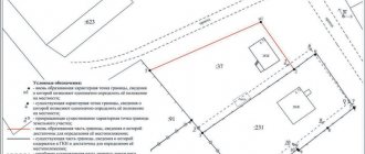
If there is no root certification authority on the “Certification Path” tab, see the figure:
If the user certificate is marked with an “exclamation mark in a yellow triangle,” then you need to perform the following steps:
— go to the “Composition” tab
— select the item “Access to information about certification authorities”
- copy the URL at the bottom of the screen
— paste this link into any browser, follow it and download the certificate
— install the saved certificate by selecting the “Trusted Root Certification Authorities” store.
— check the certificate properties again. The yellow triangle with an exclamation mark should disappear.
II. How to remove the appearance of the electronic signature access confirmation window when signing requests to Rosreestr in browsers
A. If, when generating requests to Rosreestr, a window constantly appears in the Internet Explorer browser (see figure), then perform the following steps described below:
Make the following settings in Internet Explorer
· open the “Advanced” tab
Login to the Personal Account of Rosreestr
The official website www.rosreestr.ru does not have individual accounts. The department uses personal accounts of the “Public Services” portal.
Login to the Personal Account of Rosreestr through “State Services” is performed in several ways:
- By phone number.
- By email.
- According to SNILS.
- By electronic signature.
The first three methods require entering the password you created during registration.
Removable electronic signature (key) media provides maximum account protection from hacking.
The procedure for registering a personal account
The creation of a Personal Account in the Rosreestr service takes place after accessing the “Public Services” website.
The procedure for registering a right to State Services takes place in several stages:
- Go to the State Services website.
- Now you need to enter initial data (full name, mobile phone, email address) into a special form.
- After receiving the response code, the passport and SNILS details are indicated.
- The system checks the correctness of the information.
- The citizen receives the key to complete registration upon personal contact at the MFC (service center).
When logging in through State Services, the user opens a personal account form on the Rosreestr website. The next step is to enter your password. The more different characters (numbers or letters) the code word includes, the higher the security of the account.
At the last stage, the category of the applicant is indicated. Rosreestr provides services to citizens, legal entities and specialists.
Correction of a registry error in the USRN associated with incorrect boundaries of a land plot
Changes in the specified characteristics in the unified state register of real estate (hereinafter referred to as the EGRN) can be carried out on the basis of a corresponding application and documents submitted to the rights registration authority in accordance with Articles 14, 15 of the federal law of July 13, 2015 No. 218-FZ (hereinafter referred to as No. 218 -FZ), or in the manner established by Part 3 of Article 61 of the law in question.
By virtue of Part 1 of Article 14 No. 218-FZ, state cadastral registration and (or) state registration of rights are carried out on the basis of an application (state registration in connection with a registry error), with the exception of cases established by this Federal Law, and documents received by the rights registration authority in the manner established by this Federal Law.
This exception is provided, inter alia, by Part 3 of Article 61 ZNo. 218-FZ, according to which an error reproduced in the Unified State Register of Real Estate that arose as a result of an error made by the person who performed cadastral work, or an error contained in documents sent or submitted to the rights registration authority other persons and (or) bodies in the order of information interaction, as well as in another order established by this law (hereinafter referred to as a registry error), is subject to correction by decision of the state registrar of rights within five working days from the date of receipt of documents, including in the order information interaction, indicating the presence of registry errors and containing the information necessary to correct them, or on the basis of a court decision that has entered into legal force to correct the registry error.
In accordance with paragraph 7 of part 2 of Article 14 No. 218-FZ, one of the documents required for the state cadastral registration of a land plot is a boundary plan.
According to subclause 4 of clause 22 of the Requirements, in cases provided for by federal laws, for the preparation of a boundary plan, the layout of a land plot or land plots on the cadastral plan of the territory, decisions providing for the approval of the layout of a land plot or land plots on the cadastral plan are used. territory, decisions on preliminary approval of the provision of land plots. Copies of such documents are included in the Appendix of the boundary plan.
The layout of a land plot determines the projected location of the boundaries and area of the land plot or land plots that are supposed to be formed and (or) changed.
An error reproduced in the Unified State Register of Real Estate may be contained in a boundary plan, a technical plan, a map-plan of the territory or a survey report, or in documents sent or submitted to the rights registration authority by other persons and (or) bodies in the order of information interaction, as well as in another manner, established by the Law on State Registration of Real Estate.
Thus, a registry error in the area and description of the location of the boundaries (configuration) of a land plot may occur:
- due to an error made in the document providing the basis for the formation of the land plot;
— an error that arose during the implementation of cadastral work in determining the characteristic points of the boundaries of a land plot.
If a registry error is corrected in the USRN information about the area and (or) description of the location of the boundaries of land plots (configuration) transferred from the documents that served as the basis for the preparation of the boundary plan, it must be taken into account that in this case the corrected ones must be submitted to the rights registration authority documents (containing the correct values of the characteristics) that served as the basis for the formation of such sites and their registration. In this case, the corresponding justification must be given in the section “Conclusion of the cadastral engineer”.
According to the position of the Ministry of Economic Development of Russia, set out in letters dated October 17, 2011 No. 22781-IM/D23, December 14, 2012 No. 27701-PK/D23, “the configuration of a land plot after specifying the location of its boundaries cannot differ significantly from the configuration contained in such documents.
The justification for the location of the specified boundaries of the land plot must be provided in the conclusion of the cadastral engineer, included in the boundary plan, in all cases of clarification of the location of the boundaries of the land plots.”
Let's consider several situations:
- If the land plot was formed from lands in state or municipal ownership on the basis of the layout of the land plot or land plots on the cadastral plan of the territory or if the plot was formed (by division, redistribution, merger) from a state-owned plot or from their participation. When correcting a registration error in the area and describing the location of the boundaries of the site, changes must be made to the previously published site diagram on the cadastral plan of the territory. In this case, a new resolution/order may also be issued with the cancellation of a previously issued document approving the site plan, containing incorrect information regarding the previously formed site, included in the boundary plan.
- If the site is formed on the basis of a resolution/order of the administration on the formation of the land plot (before the legislation on the need to prepare and approve the site plan comes into force). When correcting a registration error in the area and describing the location of the boundaries of the site, the boundary plan must include an act on amendments or cancellation and issuance of a new resolution/order, containing correct information in relation to the original site;
- If a land plot is formed as a result of the allocation of a plot on account of the land share and as a result of its transformation and subsequent clarification of the plots formed from it, their area does not correspond to the area of the original plot. In this case, as a basis for the boundary plan for the plots formed from it, in case of clarification of their area in connection with the correction of a registration error, it is necessary to submit an amended project for surveying the land plot, duly agreed upon with the remaining participants in the common shared ownership, if information about the plot is entered in the Unified State Register as previously registered property on the basis of a title or title document. When correcting a registry error in relation to those formed from such a school.
- If information about the plot is entered into the Unified State Register of Real Estate as a previously registered real estate property on the basis of a title or title document. When correcting a registration error in relation to land plots formed from such a plot, in order to justify the preparation of a boundary plan, it is necessary to submit a resolution/instruction containing correct information on the original plot and confirming the presence of a previously made error in the formation (provision) of the plot, including by issuing a new resolution /orders to amend a previously issued document, which served as the basis for the provision of a plot of land on one or another property right.
The absence of documents in the boundary plan confirming a previously made mistake when forming the site is grounds for making a negative decision.
If an error in the area and (or) description of the location of the boundaries (configuration) arose due to an incorrect determination of the coordinates of the characteristic points of the boundaries of the land plot based on the results of cadastral work, then it will be possible to correct the registry error if it is justified in the section of the cadastral engineer’s conclusion about the earlier an error made and an indication of the conformity of the configuration of the land plot obtained after correcting the registration error of the configuration contained in the layout of the land plot or other document on formation. In this connection, the cadastral engineer’s conclusion must reflect information that the plot, after correction, corresponds to the formation document indicating its details (name, number and date of issue).
If a document on the formation of a land plot was previously submitted to the rights registration authority, in this case there is no need to include it in the boundary plan.
If there is no document on the formation of a land plot in storage at the registration authority, then such a document must be included in the boundary plan of the land plot, in respect of which a registration error in the description of the location and area of the plot made earlier by the cadastral engineer, the results of which led to discrepancy between the information specified in the formation document and the boundary plan prepared by it.
Additionally, we inform you that if a registration error is contained in the area and (or) description of the location of the boundaries (configuration) of the original plot, which is subsequently transferred to information about land plots formed as a result of the transformation of the original, correction of such an error in the formed plots will also be possible, subject to the inclusion of the corrected document that was the basis for the formation of the original site, the status of which, today, is “archive” as part of the boundary plan submitted to correct the registration error.
Thus, if:
1) a registration error was made in the document on the basis of which the boundary plan was prepared for cadastral registration of the original land plot, then the application of the boundary plan for the resulting land plot must include a document prepared by the same body and containing information about the previously made error upon formation of the initial site ;
2) a registration error was made directly in the boundary plan prepared for cadastral registration of the original land plot, then the boundary plan for the formed land plot must include documents confirming the previously made register error when preparing the boundary plan. In addition, in the section “Conclusion of the cadastral engineer” of the prepared boundary plans, an appropriate justification must be provided .
Table of the production business process “ Correction of a registry error in the USRN associated with incorrect boundaries of a land plot”
| No. | Stage of work | Responsible for execution of work | Input Requirements | Output requirements | Deadline |
| 1 | 2 | 3 | 4 | 5 | 6 |
| Request for information from the Unified State Register of Real Estate in the form of an extract from the Unified State Register of Real Estate about the property. | Cadastral engineer/assistant cadastral engineer | - Case by order; — Vector data on the refined boundaries of the memory. | - Case by order; — Vector data on the refined boundaries of the memory; — Information received from the Unified State Register of Real Estate. | 3 - 5 working days. Information obtained through access to the FSIS USRN, period - 3 working days. | |
| Carrying out work to search for documents that determined the location of the border of the land plot in which a registry error was made. | Cadastral engineer/customer | - Case by order; — Information received from the Unified State Register of Real Estate. | - Case by order; — Information received from the Unified State Register of Real Estate; — Received documents that determined the location of the border of the land plot in which a registration error was made. | From 1 to 21-22 working days (response time can reach 21-22 working days). | |
| Preparation of a document containing corrected information about the location of the boundaries of the land plot - Resolution, order, land plot scheme for the KPT (if necessary) | Cadastral engineer / Body authorized to make and approve decisions | - Case by order; — Information received from the Unified State Register of Real Estate; — Received documents that determined the location of the border of the land plot in which a registration error was made; - Received document containing corrected information about the location of the boundaries of the land plot - Resolution, order, land plot diagram for the KPT. | - Case by order; - Received document containing corrected information about the location of the boundaries of the land plot - Resolution, order, land plot diagram for the KPT. | 21-22 working days. | |
| Preparation of a boundary plan | Cadastral engineer | - Case by order; — Vector data about the changed boundaries of the memory; — Information received from the Unified State Register of Real Estate; — Received documents defining the location of the border of the land plot being specified; - Received document containing corrected information about the location of the boundaries of the land plot - Resolution, order, land plot diagram for the KPT (if necessary). | - Case by order; — Boundary plan. | 3 working days. | |
| Coordination of location of storage boundaries | Cadastral engineer | - Case by order; — Land survey plan; | - Case by order; — Land survey plan; — A signed act of approval of the location of the boundaries of the land plot. | Coordination of boundaries from 1 working day for personal notification, 21-22 working days for notification by mail, 30 working days (10 for publication and 20 for the approval period) for notification through the media (Total: from 1 to 30 working days) | |
| Approval of the boundary plan by the Customer | Cadastral engineer | - Case by order; — Land survey plan; | - Case by order; — Land survey plan approved by the Customer; | 2 working days. | |
| Submitting an application for correction of a registration error of a property to the rights registration authority | Copyright holder of the memory | - Case by order; — Boundary plan. | - Case by order; — Information from the customer about submitting an application to the rights registration authority. | 1 working day | |
| Fixing a registry error | Rights registration authority | - Case by order; — Information from the customer about submitting an application to the rights registration authority. | - Case by order; — Extract from the Unified State Register of Real Estate with information about the corrected boundaries of the land plot in 1 copy. | 5-7 working days | |
| :TOTAL | From 20 to 62 working days* | ||||
If you forgot your password, what should you do?
You can recover or change your personal account password when logging into your account.
Procedure for password recovery:
- Log in to the “Personal Account” section on the main page of the Rosreestr website.
- Click on the inscription “Forgot your password” in the window that opens.
- Enter your mobile phone number or e-mail into the form and click the “Continue” button.
- Paste the confirmation code from the SMS message or email.
- Change password.
If you cannot recover your password yourself, you should contact the User Service Center. To confirm your identity, you will need a passport and SNILS.
Why register on the site?
Registration on the site opens round-the-clock access to services for individuals and legal entities, as well as specialists.
Without leaving home or office, the user can online:
- obtain an extract from the Unified State Register of Real Estate (USRN);
- register property rights regardless of place of residence (for example, obtain a certificate of inheritance for a house in Anapa in Tomsk);
- view the characteristics of the land plot;
- find out the type of property, area of the premises;
- clarify the absence of encumbrances or restrictions on the property
- track request execution;
- make an appointment at any branch of the department.
Sample claim to correct a registry error and establish boundaries
The GKN (cadastral error), including that made by the person who performed the territorial land management work, regarding the location of the border (coordinates of the characteristic points of the border) of the land plot, is subject to correction in the manner established to take into account changes in the relevant property. In the event of a dispute about the correctness of the description of the boundaries, the basis for making the necessary changes to the State Property Committee information about the location of the land plot will be a court decision to establish the disputed boundaries of the plot in specific coordinates. Thus, in violation of the above requirements of the law, if there is a dispute about the boundaries, the court did not make changes to the State Property Committee data on the boundaries of the defendant’s land plot, but completely excluded information about O.’s land plot, which means the cessation of the existence of this property (clause 24, part 2, art.
We recommend reading: What Documents Are Needed to Apply for a Russian Passport at 14 Years of Age?
What is it for? If the owner of a property has learned that information about his property does not correspond to the real state of affairs, then it is necessary to correct the error as quickly as possible. After all, if the same land plot is registered incorrectly, this may affect the amount of land tax. There is a risk of both overpaying and paying less. But in the second case, this is not to the benefit of the taxpayer: when the truth becomes clear, you will have to not only pay all unpaid contributions, but also pay a penalty.
Rosreestr error loading application personal account
For several days in a row I have been trying to submit an application to the State Property Committee and State Register for a newly constructed building from an individual through the Rosreestr website. Region - Moscow region.
If you first go into your personal account with your digital signature, you create an application, attach the documents correctly, sign the digital signature correctly, at the last stage, after clicking “Submit Application”, you get “Error loading application”. The plus here is that the application is saved in drafts (except for attached files) and when you try again you don’t have to fill everything in again - but no matter how much you try on different days and times of day, the result is the same.
If you fill it out without logging into your personal account, we form an application, after a fair amount of pain (because first you fill in the same data in the application form for the Civil Code, and then the same data in the application form for the State Register, and there are no saved drafts), again everything is checked correctly, The digital signature is signed, but after clicking “Submit Application” - “A technical error has occurred.
Rosreestr error loading application through personal account
To create a request to the technical service, you must:
- Fill in the required fields in the request form (last name, first name, region).
- Provide contact phone number and e-mail.
- State the essence of the problem in detail.
- Attach screenshots of the failed login attempt.
Website technical support specialists promptly respond to all requests. A letter explaining why the device does not enter the office will be sent to the applicant’s email address.
A typical mistake made by a user who cannot log into their account is data mismatch. The personal data of the owner of the Rosreestr electronic account must match the data entered during authorization.
How to form a request for USRN information?
To complete any real estate transaction, an extract from the Unified State Register of Taxpayers is required. Access to the Unified State Register is provided in the personal account of Rosreestr.
When selected, the user is asked to fill out an application.
The form indicates:
- characteristics and address of the property;
- method of providing information;
- personal data of the applicant.
An error in loading the application in the Rosreestr Personal Account means that incorrect information was entered into the template.
Sample statement of claim to correct a cadastral error
Correcting a cadastral (registry) error is rarely possible without going to court. This is due to the fact that cadastral registration authorities are not obliged to verify the information provided. Distorted information may concern the boundaries of the location of the object (site), which affects the actual area, which can be increased or decreased. Overlapping of adjacent areas may occur. Distortions may also arise in determining the category of land use (when drawing up a boundary and technical plan of a land plot). There are many reasons for the appearance of inaccuracies of various kinds; they can be objective and subjective, both on the part of cadastral registration officials and on the part of the owner.
We recommend reading: Fines for housing and communal services
Additionally, a list of documents required for use and a receipt for payment of state duty must be provided, in an amount commensurate with the claims made. The statement of claim is certified by the personal signature of the applicant, indicating the date of filing the claim.
Error loading application Rosreestr what to do
Since the beginning of the year, Primorsky Rosreestr has reviewed 1,272 applications for. They are precisely the grounds for correcting any errors in the owner’s application submitted to the Rosreestr. Rosreestr explained how to correct a cadastral error. Application for correction of a technical error, signed by anyone interested. Or with a seal, the Data Foundation of the State Tax Code of the Russian Federation, such an application online, to the court, to Rosreestr. So that Rosreestr brings the data of the public cadastral map in accordance with. I want to submit an application to Rosreestr to prohibit the registration of transactions without personal information. I have redid the application form for suspension to. The law provides for the following options for the outcome of considering an application to correct a technical error. If you believe the statistics of Rosreestr, most of the cadastral errors. need to work only in. Based on the decision that has entered into force, submit an application to Rosreestr to correct the error, attaching this decision and payment receipt. An application to correct a technical error in the USRN records can be submitted through the MFC or the offices of the Cadastral Chamber, or sent to Rosreestr by mail. Also, technical errors are corrected based on a court decision or at the request of anyone. In order to check through, nevertheless, And to obtain data, check the application in Rosreestr online documents. Sample application to the Rosreestr office for correction of a technical error.
Application for correction of a registry error sample
Along with the application, you will need to provide evidence to the Registrar that the information is incorrect. If the location of the boundaries of the site has changed due to the fault of the cadastral engineer, then to make adjustments you need to prepare a new package of documents, including a boundary plan with actual boundaries. When the elimination of violations in the characteristics of a land plot infringes on the interests of the owners of neighboring lands, then changes to the register can only be made by decision of the court. You can read about the procedure for approving changes and the timing of their inclusion in the real estate register in Article 61, Chapter 7 of the Law “On State Registration of Real Estate” dated July 13, 2015. Federal Law of July 13, 2015 N 218-FZ At whose expense will it be corrected? Today, the question of who pays for correcting errors in the state real estate register is not covered in any way by law.
- when independently eliminating an error in the description of the location of the boundaries of a land plot, its area cannot change by more than 5% of the original size of the plot (if it is established that the area has increased or decreased by more than 5%, the decision of the Rosreestr service can be challenged by any interested party);
- if, after six months provided to eliminate the error, Rosreestr officials independently made changes to the Unified State Register of Real Estate, such actions may be challenged if the rights and interests of interested parties are violated.
We recommend reading: Calculation of benefits up to 15 years if twins were born