The procedure for registering and maintaining cadastral records
What is cadastral business? This is a file that consists of documents that indicate the facts of the formation of sites, the termination of their existence, changes in their basic characteristics, if such changes were registered in the prescribed manner. It is stored in state archives even after the land plot is liquidated.
Typically, the files of existing objects are stored in the cadastral authority itself, and information from it is displayed in a single register. After the liquidation of the object, the case is deregistered, the data ceases to be displayed in the register, and the case itself is transferred to the archives for eternal storage. The legislation does not allow the destruction of archives or the removal of specific cases from it under any circumstances.
An exception to this rule is areas with a temporarily registered status. If such plots are transferred to permanent registration, then their files continue to be stored in the cadastral authority. Otherwise, they are transferred to the archive and destroyed in accordance with the procedure established by law after three years.
A package of documents and cadastral information is formed as a result of the work of specialists - cadastral engineers and employees of the state cadastral service.
Case data may be used for the following purposes:
- To carry out management in the field of nature conservation and use of natural resources.
- To protect the interests of private individuals and public interests.
- For scientific purposes when conducting research.
- In order to establish trends in changes in the quality characteristics of land.
- To create a unified federal or local plan for the implementation of cadastral work.
- To identify the price categorization of individual areas.
In any case, the use of information from the case should not contradict the provisions of the law.
Cadastral registration and registration of real estate rights
In accordance with Part 1 of Article 14 of Law No. 218-FZ, state cadastral registration and (or) state registration of rights are carried out on the basis of an application, with the exception of cases established by Law No. 218-FZ, and documents received by the rights registration authority in accordance with Law No. 218 -FZ is fine.
According to Part 4 of Article 18 of Law No. 218-FZ, the application for state cadastral registration and (or) state registration of rights is attached , unless federal law establishes a different procedure for submitting (receiving) documents and (or) information contained in such documents, the following necessary for state cadastral registration and (or) state registration of rights documents:
- document confirming the identity of the applicant
- a document confirming the relevant powers of the applicant’s representative (if his representative submits the application)
- documents that are the basis for state cadastral registration and (or) state registration of rights
- other documents provided for by Law No. 218-FZ and other regulatory legal acts adopted in accordance with it.
In accordance with Part 2 of Article 14 of Law No. 218-FZ, the grounds for state cadastral registration and (or) state registration of rights are:
1) acts issued by state authorities or local self-government bodies within their competence and in the manner established by the legislation in force at the place of publication of such acts at the time of their publication, and establishing the existence, emergence, transfer, termination of a right or restriction of a right and encumbrance real estate object;
2) contracts and other transactions in relation to real estate, concluded in accordance with the legislation in force at the location of the real estate at the time of the transaction;
3) acts (certificates) on the privatization of residential premises, completed in accordance with the legislation in force in the place of privatization at the time of its completion;
4) certificates of the right to inheritance;
5) judicial acts that have entered into legal force;
6) acts (certificates) of rights to real estate, issued by authorized government bodies in the manner established by the legislation in force at the place of issue of such acts at the time of their issue;
7) a boundary plan, technical plan or survey report prepared as a result of cadastral work in the manner established by federal law, a map-plan of the territory approved in the manner established by federal law, prepared as a result of complex cadastral work;
 scheme for placing a land plot on a public cadastral map when carrying out state cadastral registration of a land plot formed for the purpose of providing it to a citizen for free use in accordance with the Federal Law of May 1, 2016 No. 119-FZ “On the specifics of providing citizens with land plots located in the state or municipal property and located on the territories of the constituent entities of the Russian Federation that are part of the Far Eastern Federal District, and on amendments to certain legislative acts of the Russian Federation";
9) other documents provided for by federal law, as well as other documents that confirm the existence, emergence, transfer, termination of a right or restriction of a right and encumbrance of a property in accordance with the legislation in force in the place and at the time of the emergence, termination, transfer of rights, restriction rights and encumbrances of real estate;
10) the occurrence of circumstances specified in federal law.
You can clarify the full list of documents required to provide the service during a personal consultation or by calling the hotline.
Features of the formation of cadastral affairs
A cadastral file is opened only if a cadastral number is assigned to a plot.
In order for a newly created plot to be assigned such a number, the following documents must be submitted to the cadastre authority at the location of the plot:
- statement;
- title document;
- site plan (drawn up by a private engineer at the owner’s request);
- land survey verification report (carried out by service employees in order to verify the authenticity of the provided plan);
- reference information from the unified register of rights to real estate;
- technical documents from the BTI (Bureau of Technical Inventory).
All specified papers, and in some cases their copies, will be included in the cadastral file.
In addition to the above, the cadastre also includes the following documents:
- calculation plans;
- log of site numbers on the ground;
- register of plots throughout the state.
In addition to them, there is a list of additional documents of secondary importance for cadastre purposes:
We recommend that you read:
Registration of a land plot for cadastral registration
- various accounting books;
- reference information from the tax authority;
- list of plots in public ownership.
A registry file is compiled throughout the state, which includes the following:
- division plan;
- plot numbers;
- graphic representation of divisions on the map.
For this reason, the unified register contains complete information about both currently existing plots and land plots that have ceased to exist. For example, if two plots were merged, then the final number will be one of the numbers of the merged plots, but the number of the ceased to exist plot is not deleted, but is retained forever.
Cadastral Engineers Forum
Cadastral documents
- this is a set of main, auxiliary and derivative documents, maintained in Russian.
The main documents are:
the Unified State Register of Lands (USRZ), duty cadastral maps, registers of cadastral numbers, cadastral files.
Supporting documents are:
books of records of documents and issued information, catalogs of coordinates of points of the reference urban network.
Production documents
- these are analytical review documents, reference literature, lists of cadastre objects, statistical reports, derivative cadastral maps, certificates to the tax office, etc.
The Unified State Register of Lands
is a set of registration forms containing information about existing and ceased to exist cadastral registration objects.
Cadastral case
— a set of documented technical, economic and legal characteristics of a cadastre object.
The formation of a cadastral grandfather can be represented in three stages:
Stage I.
All land cadastral information is collected and documented in the cadastral file of the cadastre object (land plot + real estate firmly associated with it).
At this stage, cadastral affairs include the following operations: • determination of the spatial characteristics of the object (location, address, boundaries on the ground, coordinates of turning points of the boundaries of the land plot, buildings, structures, coordination of boundaries with adjacent land users, etc.); • definition or technical description of a real estate object located on a land plot, name, intended purpose of the object, year of construction, number of floors, foundation materials, walls, floors, ceilings, presence and type of communications, layout, area characteristics of the object, landscaping; • economic description of the object - price, including an indicator of the original (inventory) cost, replacement cost, market value.
Stage II.
State cadastral registration of a cadastre object by entering the necessary reliable and sufficient information about the object into the registration documents of the State Land Land Committee. The procedure for cadastral registration of land plots and real estate objects firmly associated with them consists of checking the completeness and correctness of the formation of the cadastral file: filling out registration forms for real estate objects; entering information about the object into the documentation of the Civil Land Registration Committee, adding new title documents to the cadastral file of the object to track the legal history of the property, drawing the boundaries of the object on the duty cadastral plan (cadastral blocks, sections), preparing a document certifying the right to the property, closing the cadastral file, transfer to the archives of state cadastral registration authorities of real estate.
Stage III.
State registration of rights to real estate is carried out by justice authorities in the Unified State Register of Rights to Real Estate and Transactions with It. Thus, the cadastral file contains three groups of documents:
First group of documents
describes the object itself and includes the following set of registers: topographic and geodetic (survey materials, cadastral plan, catalog of coordinates, explication of the site, list of areas); property (documents of technical characteristics of the object); economic (materials on the cost of assessing an object based on location, infrastructure and other qualitative characteristics), correcting general information about tax collections, etc.
Second group
includes documents certifying the subject of law himself. This is a register of legal attributes (for legal entities - name of the enterprise, organization, registration data, address, bank details; for individuals - full name, passport details).
Third group of documents
confirms the subject's right to the property: registers of titles (title document and documents confirming legal succession), registers of restrictions (encumbrances and easements).
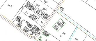
Duty cadastral map of the territory
— a special map that displays current information about the location of cadastral registration objects.
To carry out cadastral zoning based on planning and cartographic material and maintain current records, a series of duty cadastral maps and plans are created.
The duty cadastral map of a district (city) is intended to display on it the boundaries of blocks with their numbering, starting with one.
The duty cadastral map of the quarter is intended to display on it the boundaries of land plots with their numbering, starting with one.
The cadastral plan of cadastral registration objects (land plots and territorial zones) is a fragment of the duty cadastral map (plan) of the territory of a populated area showing the registration object.
Since cadastral maps and plans are a graphic display of legal descriptions of land plots, they require a mandatory similar image on a given scale of the main structural elements of the territory: the boundaries of a city or other settlement, hydrography, road network, boundaries of neighborhoods and land plots.
Real estate
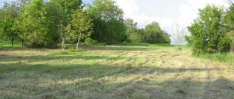
- these are land plots and all objects and parts of such objects firmly connected to the land, the movement of which is impossible without significant damage to the latter. Currently, the most studied type of cadastral work in the city is cadastral work, which ensures the formation of various forms of ownership of land plots and real estate, the implementation of paid land use, etc. Such work includes: • creation of a cadastral geodetic network; • implementation of the urban design; • structuring of the city territory; • land inventory; • land acquisition and consolidation of their boundaries on the ground; • establishing land use boundaries in existing city buildings; • cadastral survey; • qualitative and economic assessment of urban lands; • formation of land ownership.
As part of land cadastral work, a special place is occupied by:
• work to create a reliable cadastral geodetic network, continuously maintained in working condition; • removal of the city boundary project, which consists of establishing on the ground the exact position of the city boundaries and fixing the turning points of the boundaries with boundary signs.
Koroteeva L.I. “Land cadastral work. Technology and organization. Tutorial"
Read the article Land cadastral work in built-up areas. General provisions and definitions. Part 1
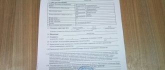
Application for cadastral registration
Registration of a cadastral file begins with the submission of an application by the owner of the land plot or the body authorized to manage state lands. The application form is simple, written, on a special form. Applications in any other form will not be accepted by the bodies authorized for registration in the cadastre.
If one form is not enough to present the full text part of the application, it is compiled on several sheets, each of which is numbered.
Applications on regular sheets are allowed only in exceptional cases. But even so, the logic and structure of the presentation must correspond to the form of the form, and all the necessary details of the document must be completed.
Upon receipt by the cadastral authority, the application receives certain details:
- registration mark;
- registration number;
- date of receipt of the application.
The “Author” column is required to be filled out in the application.
In this column you must indicate the following information:
- surname, name and patronymic of the applicant - an individual;
- abbreviated form of name and OKPO (All-Russian Classifier of Enterprises and Organizations) code for the applicant - a legal entity;
- TIN (taxpayer identification number), and in case of its absence - identity card details;
- signature.
When submitting a group application, for example, when registering common or shared property, one of the owners is indicated in this column.
Body registering cadastral records
Cadastral files for plots must be drawn up for the following purposes:
- determine the boundaries of the site;
- control land resources;
- when accounting, primary or secondary.
Two bodies are responsible for creating a cadastral file:
- land management committee;
- land management.
The main array of sites is documented by the Department's employees. All cases related to private land ownership for the purposes of individual housing construction, registration and deregistration of private land plots within settlements fall under the authority of the Office.
We recommend that you read:
What is land surveying and where to get it
The Land Management Committee carries out documentation of land plots, the intended use of which is determined by law. For example, plots for summer cottages, agricultural land, etc.
During the secondary registration of a land plot, the cadastral file of the land plot is not compiled anew. A separate inventory act is drawn up for it, and the site plan is checked, which will become the main part of the cadastral file.
The cadastral file number of the land plot must fully correspond to the cadastral number of the plot itself.
It is presented in the form of two components:
- district number according to the country's cadastral plan;
- plot number from the unified register.
The numbers are written in the specified sequence and separated by a fraction.
When preparing documents to register a land plot, it is necessary to hire private specialists accredited to carry out cadastral work. This condition also applies to government bodies when accounting for plots of public property. Particular attention must be paid to filling out documents. Documents in which corrections or additions are found will be considered invalid, and cadastral work will need to be carried out again.
At the request of the owner or as part of the planned registration of public land, land plots will be registered within one month from the date of submission of the application by the owner or from the date of the relevant decision of the authorized body.
Composition of documents required for cadastral registration
This norm provides an exact list of documents required for cadastral registration, submitted to the cadastral registration authority along with the application:
1) a document confirming payment of the state duty for cadastral registration, or a copy of a document confirming, in accordance with the legislation of the Russian Federation on taxes and fees, the existence of grounds for exemption from payment of the specified duty (when registering a property). In the second case, persons specified in the tax legislation of the Russian Federation are exempt from paying state duty. The document must be notarized;
2) a boundary plan in the case of registration of a land plot, when registering a part of a land plot or cadastral registration in connection with a change in the unique characteristics of the land plot. The document must be notarized;
3) a copy of the document confirming the resolution of the land dispute on the approval of the location of the boundaries of the land plot in the manner established by land legislation (if, in accordance with Article 38 of the commented Law, the location of such boundaries is subject to mandatory approval and the boundary plan submitted taking into account this paragraph does not contain information about the agreement on the location such boundaries). The document must be notarized;
4) technical plan of a building, structure, premises or an object of unfinished construction (when registering such a real estate object, recording part of it or taking into account its changes. The exception is a change in information: about the purpose of the building (non-residential building, residential building or apartment building), if the real estate object is a building, and the purpose of the premises (residential premises, non-residential premises), if the real estate object is a premises, or a copy of the permit to put a capital construction project into operation (during registration or when taking into account changes to such a capital construction project, with the exception of the above information)). The document must be notarized;
5) an inspection report confirming the termination of the existence of a property (when deregistering such a property);
6) a document confirming the relevant powers of the applicant’s representative (if the application is submitted by the applicant’s representative), and accordingly, this is a notarized power of attorney;
7) a copy of the document establishing or certifying the applicant’s right to the relevant property (if changes in such a property are taken into account, the address of the copyright holder is taken into account or such property is deregistered and there is no information about the registered right of this applicant to such a property in the state real estate cadastre), for example, a certificate of ownership of a particular property. The document must be notarized;
a copy of the document establishing or certifying the applicant’s ownership of the property or confirming the established or established restriction (encumbrance) of real rights to such property in favor of the applicant (when taking into account part of such property, except if the applicant is the owner of such property and The state real estate cadastre contains information about the registered ownership of this applicant for such a property). The document must be notarized;
9) a copy of a document confirming, in accordance with federal law, that the land plot belongs to a certain category of land (during cadastral registration in connection with a change in information about the category of land to which the land plot is assigned, if the property is a land plot). The document must be notarized;
10) a copy of a document confirming, in accordance with federal law, the established permitted use of a land plot (in case of cadastral registration of a land plot in connection with a change in information, the permitted use, if the real estate object is a land plot). The document must be notarized;
11) a copy of a document confirming, in accordance with federal law, a change in the purpose of a building or premises (during cadastral registration in connection with a change in information about the purpose of the building (non-residential building, residential building or apartment building), if the property is a building, or the purpose of the premises (residential premises, non-residential premises), if the property is a premises). The document must be notarized. Submission of a notarized copy is not required if the applicant or his representative personally submits the corresponding document in the original to the cadastral registration authority. This document, after being copied by the cadastral registration authority, must be returned to the applicant or his representative when issuing a receipt.
If we are talking about submitting the necessary documents to the cadastral registration body in the form of an electronic document using public communication networks, the accuracy of the electronic image of this document must be certified in the manner established by the regulatory body in the field of cadastral relations.
code for inserting into the forum - bbCode:
embed code - HTML:
Cadastral information
Documents in the cadastral file must be reflected in the public register data and provide the following information about the land allotment:
- number of the plot according to the cadastre;
- actual location (address data);
- size(area);
- information about the permitted type of land use and the category assigned by law;
- text and graphic description of allotment delimitation;
- rights of persons to land allotment;
- qualitative characteristics of the economic profitability of the site;
- information about buildings and structures located within the boundaries of the allotment.
In addition, the date of formation of the land allotment is indicated, which is the date of inclusion of the relevant information in the unified register.
This information must be confirmed by original documents in which they are indicated. But some documents, for example, title documents, can be presented in the cadastral file only as notarized copies.