How are the purposes and purpose of land determined?
The procedure for use does not depend on the size and area of the land plot, the number of owners and powers over it. When determining the order, each co-owner gets a certain share of the territory. But after its establishment, it remains undivided, the right of common ownership to it is not canceled, its component parts can be used together to move along it to the main building and other buildings.
When determining the order of land use, it is necessary to take into account the status of the object. If the land is owned by several persons, then its only condition on the basis of which the use of joint ownership is determined is the totality of the participants’ shares in the right to the common territory. At the same time, the established practice does not determine the established regulations for use, but the one that is determined by agreement of the parties. In fact, the area can be exploited by only one co-owner, while others are not interested in this or are deprived of such opportunities due to objective reasons.
The law does not establish an obligation to register the ownership of a land plot. This is a very common type of civil case and its establishment is carried out regardless of the type of rights to the object. It can be determined both between copyright holders and for those using it under the right of perpetual use or lifelong inheritable possession.
Requirements to determine the regulations for use are satisfied in lawsuit proceedings and are considered by justices of the peace. The applicant may be the owner or user of the territory whose rights are violated, and the defendant may be a co-owner or other users. In such cases, the court requires a construction and technical report to identify other ways of using it.
Determining the procedure for using a land plot
To the magistrate of the judicial district No. 867 of the Polesensky district of the Vladimir region 131214, Russian Federation, Vladimir region, Polesensky district, r.p. Polesie, st. Skosyreva, 31
Plaintiff: Osaev Igor Viktorovich, born 10/01/1976, Place of birth: Vladimir Place of residence: Russian Federation, Vladimir region, Polesensky district, r.p. Polesie, st. Leninskaya, 27. Works as technical service manager at Sovinservice LLC Tel. +7(899) 1714523
Defendants: Paluev Oscar Ramilievich, born 10/11/1963, Place of birth: Vladimir Place of residence: Russian Federation, Vladimir region, Polesensky district, r.p. Polesie, st. Odd, 171. Works as head of the HR department of PoiskKomplekt LLC Tel. +7(899) 1774121
Ilya Igorevich Natvorov, born March 30, 1981, Place of birth: Vladimir Place of residence: Russian Federation, Vladimir region, Polesensky district, settlement. Polesie, st. Stepnaya, 3. Temporarily closed. Tel. +7(899) 8507913
The cost of the claim is 10,000 rubles. State duty 400 rubles.
Statement of claim to determine the procedure for using a land plot
The plaintiff and defendants, by right of shared ownership, own a land plot with cadastral number 31:303676:98:98, with an area of 450 square meters. m., category of land: lands of settlements, type of developed use: for gardening and horticulture by citizens, located at the address: Russian Federation, Vladimir region, Polesensky district, r.p. Polesie, st. Leninskaya, 29.
Shares in the ownership of the land plot are distributed between Osaev I.V., Paluev O.R., Natvorov I.I., are equal and amount to 1/3 for each participant in the property.
The indicated shares are ideal and not allocated in kind.
In accordance with Article 2 of the Law of the Vladimir Region dated September 7, 2004 No. 139-OZ “On the maximum size of land plots provided to citizens in the Vladimir Region”, the minimum size of a land plot in the Vladimir Region for gardening purposes cannot be less than 0.06 hectares, for gardening purposes - at least 0.02 hectares.
In addition, in accordance with paragraph 13 of the Land Use and Development Rules of the Polesensky District of the Vladimir Region, approved by the Decision of the Polesensky District Duma of August 26, 2010 No. 451, regulations apply to the land plot. In accordance with the specified regulations, the minimum size of a land plot cannot be less than 0.06 hectares.
The size of 1/3 share of the disputed land plot is 0.015 hectares. In this regard, resolving the dispute between the plaintiff and the defendants by allocating a land plot in kind is not possible, since the resulting plots will have an area less than the minimum stipulated size.
In accordance with Article 247 of the Civil Code of the Russian Federation (hereinafter also referred to as the Civil Code of the Russian Federation), ownership and use of property in shared ownership is carried out by agreement of all owners, and if agreement is not reached, in the manner determined by the court.
By virtue of paragraph 2 of Article 247 of the Civil Code of the Russian Federation, a participant in shared ownership has the right to be provided for his possession and use of a part of the common property commensurate with his share.
The disputed land plot is adjacent to the land plots owned by the plaintiff as sole property (cadastral number 31:303676:98:101, area 660 sq. m., land category: lands of settlements, type of degraded use: for gardening by citizens and gardening, located at the address: Russian Federation, Vladimir region, Polesensky district, rural settlement Polesie, Leninskaya St., 31) and the defendant Natvorov I.I. (cadastral number 31:303676:98:37, area 680 sq. m., land category: lands of settlements, type of developed use: for gardening and vegetable gardening by citizens, located at the address: Russian Federation, Vladimir region, Polesensky district, r. Polesie village, Leninskaya street, 27).
In this regard, the owners of the land plot have partially developed the actual procedure for using the plot. This use is expressed in the fact that the plaintiff uses a strip of the disputed land plot adjacent to his land plot with cadastral number 31:303676:98:101, and Natvorov I.I. Accordingly, he uses a strip of land adjacent to his land plot with cadastral number 31:303676:98:37. On these strips, the soil has been cultivated, cultivated agricultural plants have been grown, and temporary facilities have been constructed that are not related to capital construction projects and are used for crop production.
Defendant Paluev O.R. practically does not use the land plot (part of the plot), which is in shared ownership of the plaintiff and defendants. However, in every possible way he interferes with the plaintiff’s use of it. Namely, it destroys plantings, clutters the site with garbage and objects incompatible with the intended purpose of the site.
In paragraph 37 of the Resolution of the Plenum of the Supreme Court of the Russian Federation No. 6 of 07/01/1996 “On some issues related to the application of Part One of the Civil Code of the Russian Federation”, it is explained that when determining the procedure for using property in common shared ownership, actual facts must be taken into account the established order of use of property, the need of each of the owners for this property and the real possibility of joint use.
In this regard, the plaintiff invited the defendants to enter into a written agreement on the procedure for using the land plot.
The main terms of the agreement are the following:
- Determine part of the land plot for the use of Igor Viktorovich Osaev with an area of 150 square meters. meters with turning points at coordinate points according to the local coordinate system (MSK-33)
| Point number | X | Y |
| 1 | 100000.01 | 200000.01 |
| 2 | 100000.02 | 200000.02 |
| 7 | 100000.07 | 200000.07 |
| 8 | 100000.08 | 200000.08 |
Determine part of the land plot for the use of Paluev Oscar Ramilievich with an area of 150 square meters. meters with turning points at coordinate points according to the local coordinate system (MSK-33)
| Point number | X | Y |
| 2 | 100000.02 | 200000.02 |
| 3 | 100000.03 | 200000.03 |
| 6 | 100000.06 | 200000.06 |
| 7 | 100000.07 | 200000.07 |
Determine part of the land plot for the use of Ilya Igorevich Natvorov with an area of 150 square meters. meters with turning points at coordinate points according to the local coordinate system (MSK-33)
| Point number | X | Y |
| 3 | 100000.03 | 200000.03 |
| 4 | 100000.04 | 200000.04 |
| 5 | 100000.05 | 200000.05 |
| 6 | 100000.06 | 200000.06 |
Inside the plot, establish the boundaries of use of the land plot by the participants in shared ownership along lines with points 2, 7; 3, 6; 4, 5.
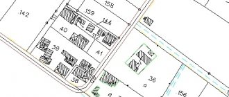
Schematic representation of parts of the land plot designated for use by Osaev I.V., Paluev O.R. and Natvorov I.I., is presented in the diagram of the boundaries of the land plot (appendix to claim No. 1).
- Install fencing of the land plot, including along the boundaries between parts of the plot, determined in favor of the parties to the agreement.
- Prohibit the construction of capital construction projects. From the boundaries of parts of the land plot, the construction of non-capital construction objects is allowed no closer than 1 meter to the fences.
- The type of permitted use of the land plot is crop production.
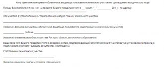
A written tripartite agreement was sent to the defendants for review, approval and proper execution (signature).
The agreement was received by the defendants, which is confirmed by the note in the postal notice dated November 24, 2019 addressed to O.R. Paluev, in the postal notice dated November 26, 2019 addressed to I.I. Natvorov.
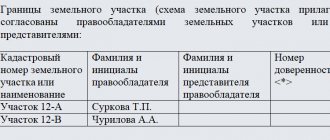
However, the agreement was not signed by the defendants. Natvorov I.I. did not provide any response, including orally. Paluev O.R. also did not sign the agreement. At the same time, in response to the proposal, he submitted a written refusal and his own version of the configuration of the boundaries of parts of the land plot (appendix to claim No. 2).
The proposed option for using the site involved defining parts of the land plot in equal strips parallel to the rear border of the site, designated by characteristic points 5, 6, 7, 8. Moreover, each strip was limited by the lateral boundaries of the site.
Considering that there is a wetland on the rear border of the site and access to the site is possible only from the front part - the village road (indicated by characteristic points 1, 2, 3, 4), access to its parts of the site is given to Osaev I.V. and Natvorov I.I. will be possible either through adjacent adjacent plots, or through the portion of the plot designated for the use of Paluev I.I. Thus, a stripe is formed.
In accordance with paragraph 6 of Art. 11.9 of the Land Code of the Russian Federation, the formation of land plots should not lead to wedging, interspersing, broken boundaries, interstriations, the impossibility of placing real estate objects and other shortcomings that impede the rational use and protection of land, and also violate the requirements established by this Code and other federal laws.
In this regard, the option for using the land plot proposed by the defendant Paluev I.I. leads to irrational use of the land, upsets the balance of interests of shared owners and, in this regard, cannot be acceptable.
At the same time, it was not possible to reach agreement on the use of the land plot, either in the wording of the agreement proposed by the plaintiff, or in any other version by the participants in shared ownership.
According to Art. 12 of the Civil Code of the Russian Federation, one of the ways to protect civil rights is to award obligations in kind.
Protection of civil rights in the current situation is possible in court.
Article 11 of the Civil Code of the Russian Federation protects violated or disputed civil rights in accordance with the jurisdiction of cases established by procedural legislation by a court, arbitration court or arbitration court.
By virtue of Article 30 of the Code of Civil Procedure of the Russian Federation, claims for rights to land plots, subsoil plots, buildings, including residential and non-residential premises, structures, structures, and other objects firmly connected with the land, as well as for the release of property from seizure, are brought to the court at the place location of these objects or seized property.
The price of the claim is determined based on the cadastral value of the land plot. According to an extract from the Unified State Register of Real Estate in relation to the disputed land plot, the cadastral value is 10,000 rubles. In this regard, the state duty is 400 rubles.
Considering the above, guided by Art. Art. 3, 23, 131, 132 Code of Civil Procedure of the Russian Federation
I beg:
1) Determine the procedure for using a land plot with cadastral number 31:303676:98:98, with an area of 450 square meters. m., category of land: lands of settlements, type of developed use: for gardening and horticulture by citizens, located at the address: Russian Federation, Vladimir region, Polesensky district, r.p. Polesie, st. Leninskaya, 29 in the following order:
allocate part of a plot of 150 square meters for the use of Igor Viktorovich Osaev. meters with turning points at coordinate points according to the local coordinate system (MSK-33)
| Point number | X | Y |
| 1 | 100000.01 | 200000.01 |
| 2 | 100000.02 | 200000.02 |
| 7 | 100000.07 | 200000.07 |
| 8 | 100000.08 | 200000.08 |
allocate part of a plot of 150 square meters for the use of Oscar Ramilievich Paluev. meters with turning points at coordinate points according to the local coordinate system (MSK-33)
| Point number | X | Y |
| 2 | 100000.02 | 200000.02 |
| 3 | 100000.03 | 200000.03 |
| 6 | 100000.06 | 200000.06 |
| 7 | 100000.07 | 200000.07 |
allocate part of a plot of 150 square meters for the use of Ilya Igorevich Natvorov. meters with turning points at coordinate points according to the local coordinate system (MSK-33)
| Point number | X | Y |
| 3 | 100000.03 | 200000.03 |
| 4 | 100000.04 | 200000.04 |
| 5 | 100000.05 | 200000.05 |
| 6 | 100000.06 | 200000.06 |
Install the fencing of the land plot in accordance with the contours of the parts of the land plot, allocating costs to the participants in shared ownership in equal shares;
Establish a restriction on the construction of non-capital construction objects no closer than 1 meter from the boundaries of parts of the land plot.
2) To recover from the defendants the costs incurred by the plaintiff in paying the state fee for the consideration of the case by a magistrate.
Application:
- A copy of the postal receipt for sending copies of the claim to the defendants;
- Extract from the Unified State Register of Real Estate in relation to the land plot;
- The text of the tripartite agreement on determining the procedure for using the land;
- Copies of postal receipts confirming the sending of the agreement to the parties;
- Copies of postal notifications of receipt of letters by the defendants;
- Scheme of the boundaries of the land plot (annex to claim No. 1);
- Configuration of the boundaries of parts of the land plot, proposed by Paluev O.R. (Appendix to claim No. 2).
01.12.2019
Plaintiff ____________ Osaev I.V.
What types of uses are there?
Download the classifier of types of permitted use of land plots.
The provisions of the current regulatory framework establish the delimitation of all lands in the state into territorial zones.
Their list is determined by the Land and Town Planning Law .
They have the following categories :
- Social and business;
- Residential;
- For transport and engineering communications;
- For agricultural purposes;
- Production;
- Special purposes;
- For the construction of military facilities;
- Specially protected lands;
- Recreational and others.
But this does not mean that such a distinction can influence the possibility of using territories only for their original purpose, since their composition is very heterogeneous.
These categories are further divided into species and subspecies . There are situations when it is permitted to use a plot not for its intended purpose, but as part of the lands to which they belong. For example, the law does not allow the construction of dachas on agricultural lands.
The town planning law defines the following types of use :
- Basic. They are determined by the owners independently and do not require additional approval;
- Conditionally permitted. Can be used after the issuance of a permit, presented following the results of public hearings held on the basis of the charter of the municipality;
- Auxiliary (supplementing the first two and not used without them).
The type of land use is determined depending on:
- Varieties of allotment, based on zoning of territories:
- Its purpose.
Grounds for the emergence and termination of rights to land plots
The grounds for use arise when an economic entity determines the possibility of granting such a right by allocating an allotment. If you wish to obtain a plot of land for use, you need to contact the authorized body, which can choose the appropriate option for the plot to be provided to you.
Contact your local administration with a request for your intention to enter into use rights. As a rule, if opportunities exist, land is provided for use without hindrance.
We can also highlight the grounds that arose as a result of a property transaction:
- When purchasing a plot of land;
- When purchasing a house (part of a house) with a plot allocated for its construction;
- Acquisition by donation, exchange or inheritance of a plot or house (part of a house) with a plot;
- Other estate plan transactions.
If you already own the site, depending on the form of title, you may be able to continue to use it based on existing precedent. However, if the land user does not have ownership rights to the land, it is best for him to obtain this right.
The general basic provisions for determining property rights are practically no different from the petition for obtaining an allotment. But the right of ownership will give additional guarantees to the landowner that the right to use the site will be defined as a permanent program that allows for continued possession of it by children and grandchildren. Other types of rights cannot guarantee this.
Accordingly, the right of use, at the discretion of the business entity, can be terminated after the death of the owner and not transferred to the heirs, if the land has not been registered as ownership. At the discretion of the authorized commission, lands may be seized by a court decision. And also, through redemption, in conditions of state necessity.
Use restrictions may be imposed on the site if an easement is established. Its establishment can be challenged in court, but this is not realistic in all cases. Judicial disputes over land issues are, in principle, quite common. This is not accidental, since a considerable share of the establishment of rights to use plots is carried out on the basis of court decisions.
The court decision regarding the right of use plays a role similar to other title documents. Therefore, when other options do not work in defending rights , the court may be the last basis for confirming them. Similarly, only through the court can the local administration terminate the right to use the site by a negligent owner.
Misuse and possible consequences
When purchasing land or acquiring the right to dispose of it, the land user must manage it in good faith, carrying out its systematic and timely processing.
When a site is presented for residential construction, it can be used to build a permanent house. Agricultural lands presented for private plots cannot be used for construction. Arbitrary construction is considered unauthorized construction and can have various legal consequences, ranging from the imposition of fines to a decision on forced demolition. In exceptional cases, things may go so far as to confiscate land .
The state regulates the operational management of plots by putting them into circulation and withdrawing them. , the requirements for their processing apply . Unused arrays are transferred to the ownerless category and returned to municipal ownership.
For violations committed by the land user, administrative liability , which is determined by the land protection inspection or the administrative commission.
The Code of Administrative Offenses determines the amount of fines depending on the type of offense committed and the category of the participant:
- For individuals – from 10 to 20 thousand rubles;
- For officials – from 20 to 50 thousand rubles;
- Organizations – from 100 to 200 thousand rubles.
Such rates are applied if it is impossible to determine the cadastral value of the property. If available, the calculation is made as a percentage of it.
Rented space may only be used in accordance with the terms of the rental agreement. Any unregulated actions with them are not allowed without the consent of the owner. The agreement may be terminated if the provisions on which it was concluded are not observed. In this regard, the right to use real estate is also terminated. Termination of the agreement is possible after the parties attempt to resolve the claim. If a conflict situation arises, the issue is referred to the courts.
Withdrawal can only be carried out after termination of the contractual relationship, and the basis for this may be:
- Coordination of the parties' actions;
- Administrative resolution;
- By the tribunal's decision.
Land is regarded by the state as one of the ways to increase the welfare of society. Owning it provides undeniable advantages and is considered by particularly enterprising citizens as an investment item to maintain their financial stability and increase capital. Such treatment of land resources is regarded as unfair and is suppressed by government services.
In addition, sometimes having received a plot of land as personal property, the owner loses the opportunity to cultivate the soil or spoils it by poisoning it with chemicals, and so on. These measures reduce the value of the soil. Such plots are transferred to the category of ownerless on the basis of an act and resolution of a special commission. If the imposed fines are not paid, the order is not fulfilled and the order of use is not returned, the owner is sent an order to recognize it as ownerless or not used in accordance with its intended purpose.
The seizure procedure is carried out by court decision.
Change of destination
The process is not easy, but it can be done.
To do this you need :
- Prepare the necessary documentation: Application for changing the type of use of the land area;
- Applicant's identity card;
- Papers establishing rights to the object;
- Documents for buildings located on the territory;
- Cadastral documentation;
- Technical passport for the building or design of the structure planned for construction;
- Information about the planned object:
- Consent of neighboring land users;
- Coordination with other land rights holders.
- Administration consent;
Changes are made within 20 days and based on the results of such actions, the copyright holder is issued an extract for the object .