Expertise related to the resolution of legal disputes occurs quite often in our work. Many have already used our services for preparing the examination and received the desired result. It is achieved through an integrated approach to measurements and competent application of legislation. This is why Land Surveyor LLC is recommended by our former Customers.
If the court, on the basis of the submitted documents, cannot make a decision in anyone’s favor in land disputes, a land management examination is appointed. More often it is briefly called “land. “The expert is appointed by the court, but participants in the process can petition for the appointment of an expert of their choice. Expertise of this type is carried out by qualified specialists (cadastral engineers). The process uses advanced techniques, geodetic equipment and specialized software.
In what cases is a land management examination carried out?
Almost always, land disputes arise due to the unlawful use of a land plot or buildings on it. That is, the boundaries of the site or building according to the documents do not correspond to the actual ones. Although there are other options. An examination may be needed in the following cases:
- if you need to establish or restore the boundaries of a land plot. If established , it means that the boundaries have not yet been registered in the cadastre and their location is determined in court. That is, in the future, land surveying and cadastral registration will be carried out by court decision. If restored , it means that the boundaries have already been cadastrally registered and for some reason do not correspond to actual use. This may be the result of a cadastral error (that is, the cadastral information is erroneous) or a deliberate violation of boundaries by third-party land users (that is, the actual boundaries are violated).
- if the survey results are questioned by the plaintiff. That is, if your own or a neighboring plot was registered in the cadastral register using a boundary plan, then its results can be challenged in court. The main thing is to find sufficient reasons.
- if it is necessary to provide passage or access to the land plot. This occurs when adjoining owners unauthorizedly occupy land intended for a right of way. Although there are cases that cadastral engineers put land plots on the cadastre without taking into account the possibility of travel to neighboring ones. According to the law, each plot of land that is not in public use must have a passage or driveway to public lands.
- if there is no direct access to public lands, the issue of establishing an easement on the neighboring plot is resolved.
- if the building erected on the site does not comply with construction regulations or fire safety. That is, if its location on a given land plot is illegal.
- if it is not possible to divide or allocate a land plot in a pre-trial manner. That is, if the owners or shareholders of the land cannot determine the boundaries peacefully.
To summarize this section, we can say that a judicial land survey is needed by the court to obtain detailed and reliable information about the location, area and other significant characteristics of the site in order to make a decision. After all, the judge himself is not always well versed in land relations, especially in terms of the actual use of the land plot. Cadastral engineers preparing forensic examinations help make the right decision.
Land management examination.
Land management examination or land examination is a complex of technical and legal work to determine the compliance of the previously completed survey with the existing documents for the disputed object, as well as the compliance of the actual use of the land plot, building, structure with the legal documents. The most common is the examination of land plots, the need for which arises when resolving territorial disputes between adjacent land users and dividing land plots. Land examination can be carried out both by a court decision ( judicial land management examination ) and out of court under an agreement between the land user and an expert organization.
A land survey is carried out to establish the following circumstances:
1) compliance of the actual area of the land plot with its area in accordance with the legal documents;
2) determination of the area of the land plot necessary for the use of the property located on this plot for its intended purpose;
3) the presence of real estate owned by the plaintiff on the land plot that is the subject of the dispute - when considering disputes about compulsion to conclude a contract of sale or lease of a land plot, disputes about recognizing contracts of sale or lease of a land plot as invalid or not concluded;
4) the presence of an overlap between the boundaries of land plots owned by the plaintiff and the defendant - when considering disputes regarding the recognition of lease or purchase and sale agreements for land plots as invalid in connection with the overlap of the boundaries of the land plots of the plaintiff and the defendant;
5) the fact that the defendant’s property is located on the plaintiff’s land plot - when considering negative claims related to the protection of property rights.
6) determination on the ground of the boundaries of the land plot, determination of its actual area.
7) determining the location of the property relative to the boundaries of the land plot.
 division (allocation of share) of a land plot.
9) obtaining an expert opinion on the division of the land plot.
Stages of land management examination:
1. Collection and analysis of title documents;
2. Establishing the boundaries of a land plot on the ground;
3. Drawing up an expert opinion;
Until 2009, land management expertise was combined with construction and appraisal expertise into a single expert specialty No. 16.1 “Investigation of construction sites and the territory directly related to them, including for the purpose of their assessment.”
At the end of 2009, the leading center for the training of forensic experts, which is the NP "Chamber of Forensic Experts", by its internal decision raised land management examination to a new level, giving it the following names, depending on the goals and objectives of the study: No. 16.7 Research of land plots for the purpose determination of boundary boundaries and establishment of their correspondence to actual boundaries and No. 16.3 Study of households in order to establish the possibility of their real division between the owners in accordance with the conditions set by the court; development of options for this section. From January 1, 2011, any type of cadastral work based on the results of which boundary plans are prepared can only be carried out by individuals who have passed the qualification exam and received a qualification certificate as a cadastral engineer. Boundary plans prepared after January 1, 2011 by a person who has not received a qualified cadastral engineer certificate, in accordance with clause 7, part 2. Art. 27 of the Federal Law of July 24, 2007 No. 221 “On the State Real Estate Cadastre”, the cadastral registration authority decides to refuse to carry out cadastral registration.
As part of judicial and extrajudicial land management examinations, experts from NEOO EXPERT LLC will perform expert work on:
- land surveying: establishing and restoring the boundaries of land plots (by court decision);
- determining the location of the boundaries of land plots on the ground, restoration according to the state real estate cadastre;
- determining how the boundaries of land plots should be restored if inconsistencies in the documents are identified;
- identifying the presence of cadastral errors in the information of the state real estate cadastre (overlapping boundaries of land plots);
- compliance with the actual area of the land plot - the area in accordance with title or title supporting documents, a certificate of state registration of rights, in accordance with the cadastral passport;
- determining options for dividing home ownership (research of home ownership in order to establish the possibility of their actual division between owners in accordance with the conditions set by the court; development of options for this division);
- determining the procedure for using the land plot;
- determining the availability of real estate on the disputed land plot;
- and other questions.
- In addition to expert activities, the organization provides geodetic services, in accordance with the license for geodetic activities No. 61-00010G.
LIST OF SAMPLE QUESTIONS SOLVED BY EXAMINATION
(section: “land management examination issues”)
- Determine how much area of land is occupied by a particular construction project?
- Determine how much land area is free from development?
- Determine whether it is possible to erect a particular construction project with such and such parameters on the land plot under study? If impossible, then for what reasons?
- Determine what special rules, methods and norms in the field of land management, land cadastre, urban planning and construction were violated during the construction of a certain construction project (house, cottage, cottage or fence) on the territory of the land plot under study?
- Determine what special rules, methods and norms in the field of land management, land cadastre, urban planning and construction were violated during the preparation of the following land management documentation?
- Determine the exact cartographic (geographical) boundaries (coordinates) of the land plot under study?
- Determine whether the boundaries of the land plot under study overlap the border of the neighboring land plot, and if so, what is the area of such overlap?
- Submit for consideration by the court options for dividing the land plot in accordance with their shares established in the title documents, taking into account (or without taking into account) the actual order of use of the land plots.
- You can also pose the following questions to the expert: (approximate list, questions may vary depending on the situation under the section “land management examination questions”).
1) Determine the actual location of the boundaries of land plots at the address: Rostov-on-Don, st. Krasnykh Zori, building ___ and Rostov-on-Don, st. Red Dawns, house____. 2). Does the actual area of the land plot located at the address: Rostov-on-Don, st. Krasnye Zori, house, cadastral number 61:44:0180305:57, area in accordance with the title or title document (indicate with which document, for example: resolution No. ___ dated "___" ___20__, purchase and sale agreement No.____ dated "____ " ______1966, certificate of state registration of rights, series No. _____ dated "____"_____ 20__), and in accordance with cadastral passport No. _____ dated "__" _____ 20__. 3). Do the actual areas of land plots at the address: Rostov-on-Don, st. Krasnykh Zori, house cadastral number: 61:44:0180305:57, and at the address: Rostov-on-Don, st. Krasnye Zori, house cadastral number: 61:44:0180305:58 area according to title documents (indicate which title documents No.) 4) Do these land plots overlap each other, and what is the area of overlap? 5) Are there any shifts in the boundaries of the land plot at the address: Rostov-on-Don, st. Krasnykh Zori, building 75 cadastral number: 61:44:0180305:57, in accordance with land management file No. ____ dated “__” ___ 20__ and cadastral extract of the land plot No. ___ dated “___” ______ 20__. 6) Do the boundaries, configuration and dimensions of the disputed land plots comply with the location diagram No.___ from “___” ____ 20_, issued by the Administration. 7) If inconsistencies between boundaries are identified, determine how the boundaries of land plots at the address: Rostov-on-Don, st. Krasnykh Zori, house, and at the address: Rostov-on-Don, st. Krasnykh Zori, house Provide the court with options for restoring the boundaries of the land plots, at the address Rostov-on-Don, st. Krasnykh Zori, house and address Rostov-on-Don, st. Red Dawns, house. 9) What are the reasons for the imposition of boundaries of land plots (cadastral or technical error). 10) Is it possible to eliminate the reasons for crossing the boundaries of land plots without changing the area and configuration of land plots at the address: Rostov-on-Don, st. Krasnykh Zori, house, and at the address: Rostov-on-Don, st. Red Dawns, house.
 - You can see on the forum a list of questions for the expert, a cadastral error (overlapping land boundaries) and how to correct it!
https://www.neooexpert.ru/forum/index.php?/forum/20-zemleustroitelnaia-ekspertiza-ili-zemelnaia-e/
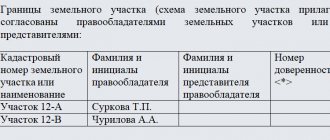
In accordance with Art. 34. Federal Law No. 221 of July 24, 2007 “On the State Real Estate Cadastre”, cadastral engineers have the right to create, on a voluntary basis, non-profit associations in the form of a non-profit partnership based on the membership of cadastral engineers, in order to ensure conditions for the professional activities of cadastral engineers, establishing mandatory for members of such associations, rules for carrying out cadastral activities, rules of conduct when carrying out these activities, rules of business and professional ethics of cadastral engineers, as well as for the purpose of monitoring compliance with these rules, improving the qualifications of cadastral engineers (hereinafter referred to as self-regulatory organizations in the field of cadastral activities) . According to paragraph 2 of Art. 35 of the Federal Law of July 24, 2007 No. 221 “On the State Real Estate Cadastre”, in cases provided for by the legislation of the Russian Federation, cadastral work can be performed by a cadastral engineer based on a court ruling. The court is independent in choosing the appropriate cadastral engineer. Expenses associated with the implementation of such cadastral work and monetary remuneration to the relevant cadastral engineer are subject to reimbursement and payment in the manner established by the legislation of the Russian Federation.
As a result of cadastral work, the cadastral engineer transfers the following documents to the customer:
1) boundary plan (when performing cadastral work, as a result of which the preparation of documents is ensured for submission to the cadastral registration authority of an application for registration of a land plot or land plots, for recording changes in a land plot or for registering a part of a land plot);
2) technical plan (when performing cadastral work, as a result of which the preparation of documents is ensured for submitting to the cadastral registration body an application for registration of a building, structure, premises or object of unfinished construction, for accounting of its changes or accounting of its part);
3) an inspection report (when performing cadastral work, which results in the preparation of documents for submission to the cadastral registration body of an application for deregistration of a building, structure, premises or unfinished construction site).
LAND MARKETING
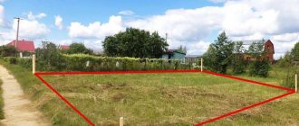
To carry out land surveying, you need to contact a cadastral engineer with documents for the land and conclude an agreement to perform cadastral work. Land surveying must be carried out in accordance with the Land Code of the Russian Federation, the Town Planning Code of the Russian Federation, Federal Law of June 18, 2001 N 78-FZ “On Land Management”, Regulations on the procedure for establishing land use boundaries in the development of cities and other settlements, instructions for land surveying and others regulatory and technical documents in the field of territorial land management. Land surveying is a set of works to establish, restore and secure the boundaries of a land plot on the ground, determining its location and area. Land surveying (establishing and securing boundaries) on the ground is carried out when citizens and legal entities receive new land plots, when buying and selling, bartering, donating all or part of a land plot, as well as at the request of citizens and legal entities, if documents certifying them rights to a land plot were issued without establishing and securing boundaries on the ground. Restoration of the boundaries of a land plot is carried out in the presence of boundary disputes, as well as at the request of citizens and legal entities in the event of complete or partial loss of boundary signs and other signs of the boundaries of their land plots on the ground.
DIVISION OF LAND
The division of land plots is carried out in accordance with the Land Code of the Russian Federation. When preparing documents for land plots, copyright holders encounter this method of creating land plots quite often. For example, when dividing a privately owned land plot, when the owner of real estate located on it needs to sell one or more such objects. It should also be noted that the division of land plots is possible provided that the original land plot is divisible. In accordance with clause 4. Art. 11.9 of the Land Code of the Russian Federation, division is not permitted if the encumbrances (restrictions) remaining in relation to the land plots being formed do not allow the use of these land plots in accordance with the permitted use. If these conditions are not met, it will be necessary to draw up documents for shared ownership. When a land plot is divided, its owner acquires the right of ownership to all such land plots formed as a result of the division. When dividing a land plot that is in common ownership, the participants in common ownership retain the right of common ownership to all land plots formed as a result of such division, unless otherwise established by agreement between such participants. In accordance with clause 11.4, clause 4 of the Land Code of the Russian Federation, the division of a land plot provided to a horticultural, gardening or dacha non-profit association of citizens is carried out in accordance with the project for organizing and developing the territory of this non-profit association or another document establishing the distribution of land plots in this non-profit association. When dividing such a land plot, one or more land plots may be formed, intended for a citizen to carry out gardening, gardening or dacha construction, or related to public property. In this case, the land plot, the division of which was carried out, remains within the changed boundaries (changed land plot). When dividing a land plot provided for complex development for the purposes of housing construction, the implementation is carried out by the person with whom the lease agreement for the land plot for complex development for the purposes of housing construction is concluded, in accordance with the territory surveying project approved in the manner established by the legislation on urban planning activities. To formalize the rights of each owner of a real estate property to a separate land plot on which the real estate is located, including through purchase (privatization), it is necessary to form such land plots (to carry out land surveying) and register them with the state cadastral register (GCU).
ASSOCIATION OF LAND PLOTS
The consolidation of land plots must be carried out in accordance with Article 11.6 of the Land Code of the Russian Federation. The result of combining adjacent land plots is the formation of one land plot. In this case, the existence of such adjacent land plots ceases. Consolidation of land plots is necessary, for example, when one person owns several adjacent land plots and this person needs to carry out construction on such land plots. In the case of a merger of land plots, the owner acquires the right of ownership to the resulting land plot, and when merging land plots owned by different persons, such persons acquire the right of common ownership of the resulting land plots. If land plots belong to the right of common ownership to different persons, then when the land plots are united, they have the right of common ownership of the resulting land plot in accordance with civil law. It is also necessary to pay attention to the fact that the consolidation of land plots is not allowed if they are provided on the right of permanent (indefinite) use, the right of lifelong inheritable possession or the right of free fixed-term use, except in cases where all of these land plots are provided on the right of permanent (indefinite) use, the right of lifelong inheritable possession or the right of gratuitous fixed-term use to one person. It is allowed to combine a land plot encumbered with a mortgage with a land plot not encumbered with a mortgage. In this case, the right of pledge extends to the entire land plot being formed, unless otherwise provided by agreement of the parties.
ALLOCATION OF LAND PLOTS
The allocation of a land plot is carried out in the case of the allocation of a share or shares from a land plot that is in shared ownership. When a land plot is allocated, one or more land plots are formed. In this case, the land plot from which the allocation was made remains within the changed boundaries (changed land plot). When a land plot is formed by allotment, the participant in shared ownership, upon whose application the land plot is allocated, acquires the right of ownership to the land plot being formed and the said participant in shared ownership loses the right of shared ownership in the changed land plot. Other participants in shared ownership retain the right of shared ownership of the changed land plot, taking into account the changed size of their shares in the right of shared ownership. The specifics of allocating a land plot against land shares are established by the Federal Law “On the Turnover of Agricultural Land”. Redistribution of land plots. When several adjacent land plots are redistributed, several other adjacent land plots are formed, and the existence of such adjacent land plots ceases. When redistributing privately owned land plots, their owners acquire ownership rights to the corresponding land plots being formed in accordance with agreements between such owners on the formation of land plots.
You can get advice from our specialists or order an examination:
— by a single telephone (calls within Russia are free) 8-800-500-32-03
- by email;
— by filling out an online application on our website.
Photo: ya.ru
land management expertise, land management expertise in Rostov, land management expertise in the Rostov region, land management expertise in Voronezh, land management expertise in the Voronezh region, land management expertise in Volgograd, land management expertise in the Volgograd region, land management expertise in Stavropol, land management expertise in the Stavropol Territory, land management expertise in Krasnodar, land management expert Iza Yeysk, land management expertise in Krasnodar region, land management examination in Crimea, land management examination in the Republic of Crimea, land management examination in Simferopol, land management examination in Grozny, land management examination in Chechnya, land management examination in Vladikavkaz, land management examination in RSO Alania, land management examination in Moscow, land management examination throughout Russia, land management examination for the court, land placement examination for Rostov courts, land management expertise for the Voronezh court, land management expertise for the Rostov-on-Don court, land management expertise for the Volgograd court, land management expertise for the Stavropol court, land management expertise for the Krasnodar court, land management expertise for the Yeisk court, land management expertise for the Simferopol court, land management expertise for Crimea courts, land management expertise for the Simferopol court, land management expertise for the Chechnya court, land management expertise for the Grozny court, land management expertise for the RSO Alanya court, land management expertise for the Vladikavkaz court, land management expertise for the court throughout Russia, land management expertise for the Moscow court, land management expertise questions for the court, land management examination for the court questions Russia, land management examination for the court questions throughout Russia, land management examination for the court cost, land management examination questions for the expert, land management examination registry error questions for the expert, land management examination is, land management forensic examination, land management forensic examination Rostov , land management forensic examination in Rostov-on-Don, land management forensic examination in Voronezh, land management forensic examination in Volgograd, land management forensic examination in Stavropol, land management forensic examination in Krasnodar, land management forensic examination in Yeisk, land management forensic examination in Crimea, land management forensic examination in Simferopol, zemleu construction forensic examination in Grozny, land management forensic examination in Chechnya, land management forensic examination in Vladikavkaz, land management forensic examination in RSO Alania, land management forensic examination throughout Russia, land management forensic examination in Moscow, land management forensic examination in the Moscow region, land management documentation, land examination, land examination in Rostov, land management forensic examination in Rostov-on-Don, land expert isa Voronezh, land examination in Volgograd, land examination in Stavropol, land examination in Krasnodar, land examination in Yeysk, land examination in Simferopol, land examination in Crimea, land examination in Chechnya, land examination in Grozny, land examination in Vladikavkaz, land examination in RSO Alania, land examination throughout Russia, land examination of the Russian Federation, land examination in Moscow, land examination for the court, land examination for the court of Rostov, land examination for the court of Rostov-on-Don, land examination for the court of the Rostov region, land examination for the court of Voronezh, land examination for the court of the Voronezh region, land examination for the court Volgograd, land examination for the court of the Volgograd region, land examination for the court of Stavropol, land examination for the court of the Stavropol Territory, land examination for the court of Krasnodar, land examination for the court of the Krasnodar Territory, land examination for the court of Yeysk, land examination for the court of the Crimea, land examination for courts in Simferopol, land examination for the court throughout Russia, land examination for the court in Grozny, land examination for the court in Chechnya, land examination for the court in Vladikavkaz, land examination for the court in the Republic of North Ossetia, Alania, land examination for the court in Moscow, land examination for the court in the Moscow region, land examination for the court price, land examination for the court cost, land examination for the court questions, land examination for the court who pays, land examination is, surveying a land plot, surveying a land plot in Rostov, surveying a land plot in Voronezh, surveying a land plot in Rostov-on-Don, surveying land plot in Volgograd, land survey in Grozny, land survey in Stavropol, land survey in Chechnya, land survey in Crimea, land survey in Simferopol, land survey in RSO Alania, land survey in Vladikavkaz, land survey throughout Russia, land survey Moscow, surveying a land plot is, surveying a land plot is a definition, surveying a land plot is defining boundaries, division of land plots, division of land plots, division of a land plot, consolidation of land plots, consolidation of land plots into one from one owner, consolidation of land plots into one one owner procedure, merging land plots with different permitted uses, merging land plots with different permitted uses in a lease, merging land plots into one with one owner, merging land plots into one with one owner documents, merging land plots leased, consolidation leased land plots are prohibited, association of land plots leased by auction, association of land plots owned, association of state-owned land plots, association of privately owned land plots, association of land plots land code, association of land plots what is it , allocation of a land plot, allocation of a land plot is, allocation of a land plot is a transaction, allocation of a land plot is an example of a boundary plan, allocation of a land plot from a common shared property, allocation of a land plot from a common shared property, judicial practice, allocation of a share in kind of a land plot from a common shared property property, judicial practice, allocation of a share of a house and land plot in kind, judicial practice, allocation of a share of a house and land plot in kind, court decision, allocation of a share of a house and land plot in kind, allocation of a land plot to large families, allocation of a land plot to disabled people, allocation of a land plot in in kind, allocation of a land plot in kind from common shared ownership, allocation of a land plot in kind is, allocation of a land plot from a single land use, allocation of a land plot on account of a land share, allocation of a land plot on account of a land share, what is it, allocation of a land plot under an apartment building , allocation of a land plot for a residential building, allocation of a land plot to disabled people, allocation of a land plot to disabled people of group 1, allocation of a land plot to disabled people of group 2, allocation of a land plot to disabled people of group 3, allocation of a land plot from municipal property, allocation of a land plot for construction, allocation of a land plot for the construction of a residential building, allocation of a land plot for the construction of a residential building in a rural area, allocation of a land plot for the construction of a garage, allocation of a land plot for a garage cooperative, allocation of a land plot for premises, allocation of a land plot for non-residential premises, allocation of a land plot from another land plot , allocation of a land plot from another land plot in Russia, allocation of a land plot without bidding, allocation of a land plot without bidding for subsoil use needs, judicial practice, allocation of a land plot for free, allocation of a land plot from common shared ownership, allocation of a share of a land plot from common shared property property, allocation of a share of a land plot from common shared ownership through the court, allocation of a share of a land plot in kind, allocation of a share in kind from common shared ownership of a land plot
Who can prepare a forensic land survey?
Unfortunately, the law does not clearly regulate the specialization of a land expert. Order of the Ministry of Justice of the Russian Federation dated December 27, 2012 No. 237 contains a list of specialties for all types of examinations. In particular, it is indicated for land examination - “the study of land management objects, including the determination of their boundaries on the ground.” That is, someone who can determine the boundaries on the ground. And in the main Federal Law on Forensic Expert Activities No. 73, Article 13 quite “generally” lists the requirements for an expert: he must be a citizen of the Russian Federation, have a higher professional education and training in a specific expert specialty.
It will be difficult for a simple surveyor-topographer to carry out such an examination, because his specialty does not include knowledge of the legal subtleties in real estate registration. Based on the above, only a cadastral engineer can be an expert. By the nature of his activity, he is precisely engaged in determining the boundaries of objects on the ground and further supporting and preparing documents for registration of land plots and buildings. When choosing an expert, the key point should be the length and experience of the cadastral engineer. Therefore, we recommend that the customer first communicate with the proposed contractor. Find out his opinion on your case and evaluate his answers.
What is the advantage of land management examination of a land plot?
After conducting a land management examination of the land plot, the owner receives a document that proves the correctness of all specified data on it. Using such a document, you can solve a number of problems that have arisen, for example:
- disputes between neighbors based on the imposition of boundaries of adjacent land plots, since after the procedure they will be clearly defined;
- eliminate the presence of inconsistencies in the actual area of the land plot and the data available in the cadastral passport;
- exclude the presence of other people's property on the land plot;
- If it is necessary to divide a land plot, a land management examination will help determine possible options for the procedure.
What guides a land expert?
There are several fundamental documents that directly regulate or indicate the procedure and content of land management examination:
- First of all, this is the Land Code of the Russian Federation of October 25, 2001.
- Federal Law “On Land Management” dated June 18, 2001. Describes the basic principles and concepts in land management.
- Federal Law “On the State Real Estate Cadastre” dated July 24, 2007. Describes cadastral and legal relations with the state.
- Federal Law “On State Forensic Expert Activities in the Russian Federation” dated May 31, 2001. This defines the requirements directly for experts.
- Criminal Code of the Russian Federation of June 13, 1996. Here the expert is concerned mainly with Article 307 on giving deliberately false testimony in court.
Naturally, all these documents have undergone many edits and changes since the first edition (the date in the list) through new federal laws. When conducting an examination, experts are always guided by the latest editions.
Questions for land management examination when challenging the surveying of a land plot
When challenging the results of erroneous land surveying in court, special knowledge in the field of land management is always required. This makes it necessary to conduct a judicial land management examination in such cases.
In accordance with Part 2 of Art. 79 of the Code of Civil Procedure of the Russian Federation, each of the parties and other persons participating in the case has the right to present to the court issues to be resolved during the examination. The final range of issues on which an expert opinion is required is determined by the court. The court must provide reasons for rejecting the proposed questions.
In reality, judges usually formulate questions for experts in their own wording and almost never motivate the rejection of questions proposed by the parties to the dispute. At the same time, in my practice it has happened more than once that judges accepted my version of questions for experts. In this regard, I believe that posing questions for examination should be approached responsibly, and a petition with questions should be drawn up in writing so that it remains in the case file.
An approximate list of questions that can be raised for resolution by an expert in a case of challenging the results of an erroneous land survey looks like this:
- take measurements of land plots No. ... and No. ... located at the address: ...;
- what are the actual areas of the plaintiff’s land plot with cadastral number ... at the address: ... and the defendant’s land plot with cadastral number ... at the address: ...? Do they correspond to the areas of land plots according to title documents? If not, what was the reason for the discrepancy and how to eliminate it?
- does the location of the actual boundaries of the plaintiff’s land plot with cadastral number ... at the address: ... and the defendant’s land plot with cadastral number ... at the address: ... correspond to the title documents and land surveying documents? If not, what was the reason for the discrepancy and how to eliminate it?
- whether the location of the boundaries of the plaintiff’s land plot with cadastral number ... at the address: ... and the defendant’s land plot with cadastral number ... at the address: ... corresponds to the general plan (or other territorial planning documents available in the case): ... according to actual use and according to the state real estate cadastre ? If not, what was the reason for the discrepancy and how to eliminate it?
- is there an overlap (intersection) of the boundaries of the plaintiff’s land plot with cadastral number ... at the address: ... and the defendant’s land plot with cadastral number ... at the address: ... according to actual use and according to the state real estate cadastre? If yes, then indicate the area and boundaries of the overlap area, indicating the coordinates of the characteristic points of such boundaries. Indicate the reason for the overlap of boundaries and how to eliminate it?
- prepare possible options for establishing the boundaries of the plaintiff’s land plot with cadastral number ... at the address: ... and the defendant’s land plot with cadastral number ... at the address: ... indicating the areas and coordinates of characteristic points of the plot boundaries.
I repeat that this list is approximate. The specific questions depend on the circumstances of the case.
What does an expert need to conduct an examination?
In court proceedings, experts work within a clearly defined legal framework established by law. This is important to understand when applying for an examination.
- The main document is the court case. It is important that the expert does not have the right to use any materials other than those that appear in the court case. Also, in his conclusion, he cannot answer additional questions from the plaintiff and defendant that are not listed in the list of questions for the forensic expert. An important rule follows from the above: it is necessary to carefully approach the documents presented to the court and the questions formulated for examination. Moreover, you can apply to include the issue you are interested in on the list for examination. The expert land surveyor will not answer legal questions. That's what a judge is for.
- The court case must contain: - Geodetic coordinates of the land plot - Dimensions of the plot and its topographical characteristics - Time limits within which the expert opinion must be submitted - Questions posed by the court to the forensic expert - Title documents for the land plot - Other documents related to the land plot (previous examinations, topographic plans, technical passports for real estate, etc.)
- The expert himself must have a valid cadastral engineer certificate and all the necessary equipment and software for field survey and determination of the location of characteristic objects on the ground.
- To prepare a conclusion, the expert must conduct field work at the disputed site. Accordingly, he must be provided with access to all places where he considers it necessary to go for measurements. If access is deliberately denied by one of the parties to the proceedings, the forensic expert will definitely include this in the examination. Subsequently, the court will consider this a concealment of evidence and make a decision not in favor of the offender (as in the case of refusing a medical examination of a drunk driver).
So, to work, an expert needs a court case, specialized devices and programs, and so that his work is not interfered with by either interested or outsiders. Next we will put them in order.
The procedure for conducting the examination
The following describes the procedure for passing the initial land management examination:
- appointment of a forensic expert by the court at its discretion, or at the request of one of the parties
- study of judicial issues posed to the expert and verification of documents provided by the court for the examination
- reconnaissance and inspection of an object on the ground. Checking the compliance of documents with the situation on the ground,
- geodetic survey of the disputed land plot indicating all buildings, communications and fences. It is worth making sure that the measurements are carried out by the appointed expert. You can also ask about the name and serial numbers of the devices used during the work. They must correspond to those specified in the examination.
- processing of field measurement results using specialized software products,
- drawing up an expert opinion providing answers to the questions posed by the court and a graphical application for a visual representation of the essence of the dispute. Drawed up in at least 2 copies - 1 to the court, the rest to the Customer’s representative.
After receiving a copy of the examination, it would be useful to check what materials and data the expert used to make his conclusion. If third-party sources were used, this is a reason to recognize the examination as unlawful. In some cases, you can and should disagree with the conclusion.
Geodetic work on land management expertise
A geodesy examination by court decision (land management forensic examination) is appointed by a judge at the request of one of the parties to a land management dispute when considering a civil claim in court, if it was not possible to reach a settlement of the dispute in pre-trial order. Such a petition establishes a list of land management examination questions to which unambiguous answers must be received. Full-scale geodetic measurements carried out by the forensic expert make it possible to control land surveying: checking the location (allotment) of the site, checking the boundaries of the site (the presence or absence of overlapping sites), checking the area and other necessary conclusions. The cost of the land survey, as well as the state duty for filing a claim, attorney fees and possible moral damages are recovered from the guilty party by court decision.
© Geodetic, Moscow, Russian Federation.
Terms and cost of land management examination
The deadline for preparing the conclusion of the land forensic examination is set by the court. This usually ranges from 2 weeks to several months, depending on the amount of work facing the expert. On average, 1 month is prescribed.
The cost of the examination also varies greatly depending on the number and complexity of questions asked by the court for the expert. Therefore, before applying for a forensic examination in general or to engage a specific expert, you need to understand how much it will cost. To do this, you need to call the supposed expert and bring him up to date. An objective price will be offered based on your specific case. On average, the examination costs from 40 thousand rubles. in the Moscow region and from 80 tr. in Moscow.
will carry out work on land issues of any complexity.
Our experience, developed material and technical base and high qualifications of our specialists allow us to carry out work at the highest level and in the shortest possible time.
Even if you do not dare to contact our company, do not fall for big discounts and super-profitable offers - most likely these are scammers or unscrupulous performers. Quality work will not cost very little.
Prices of our services
You can just write
Our social networks:
Phone: 8 (903) 253-35-84, Ilya
Land Surveyor LLC For you!
In some areas of the Moscow region, services for preparing a forensic land management examination are somewhat cheaper. This is due to lower transport costs. Here is their list: Leninsky, Lyuberetsky, Kotelniki, Dzerzhinsky, Domodedovo, Ramensky, Zheleznodorozhny, Balashikha, Noginsky, Odintsovo, Podolsky, Podolsk, Klimovsk, Krasnogorsky. Check the price by calling 8-903-253-35-84, Ilya.