A land plot that is already registered has its own unique cadastral code. If not, then to get it, you need to carry out a land surveying procedure. It implies fixing the exact boundaries of the selected area, allowing any dispute over the boundaries of land owned privately or publicly to be resolved in advance.
Obtaining a state registration number for a plot begins with the immediate formation of its boundaries. This procedure is carried out by employees of the Cadastral Chamber, and the procedure itself will require the following package of documents:
- application for assignment of a number;
- approved boundary plan;
- documents confirming the identity of the applicant or a correctly drawn up power of attorney, if there is a case of representing the interests of third parties;
- for the merger, redistribution or division of plots, a document confirming the consent of all owners is required;
- a written statement from users, tenants or mortgagees, including banks, whose rights relate to the areas in respect of which the application has been submitted.
Site number changes
In order to assign another unique number to a land plot or deregister it, a number of formalities must be observed. Each case requires a special package of documents. A change or restoration of the number is required if the unique data of the land plot or other characteristics are lost or no longer correspond to those specified in Rosreestr. In order to receive it again, you will need to submit an application and relevant documents from the owners and the Cadastral Chamber.
Deregistration will be required if the land or dacha plot has ceased to exist as such. The reasons for initiating the withdrawal procedure are usually:
- technical error in the cadastral registration system;
- the appearance of tears or overlaps between adjacent areas;
- rights and encumbrances on registered land, the statute of limitations for the formation of plots on which exceeded two years or was not registered.
Dear readers!
Our articles talk about typical ways to resolve legal issues, but each case is unique. If you want to find out how to solve your specific problem, please contact the online consultant form on the right →
It's fast and free!
Or call us by phone (24/7):
If you want to find out how to solve your particular problem, call us by phone. It's fast and free!
+7 Moscow,
Moscow region
+7 Saint Petersburg,
Leningrad region
+7 Regions
(free call for all regions of Russia)
The meaning of the numbers in the number
The first two digits in it indicate the region where the land plot is located, the next two indicate the district, then comes the number of the block in which the plot itself is located and, finally, the final combination of numbers refers to the numbering of a specific plot in this location.
Knowing the cadastral number, any plot can be easily identified on the ground, even if its boundaries are not registered. For example, 69:10:0000008:749 means the following:
- 69 - Tver region.
- 10 - Kalininsky district.
- 0000008 - the block in which the object is directly located.
- 749 - memory number.
However, some objects are registered without the coordinates of their boundaries . This applies to those land plots that were entered into the database on the basis of available archival data or registered before the introduction of a new coordinate system by the cadastral chamber in 2008.
In both cases, such objects cannot be taken into nature, that is, their boundary points on the ground cannot be accurately determined. Therefore, in order to avoid misunderstandings, you need to contact an engineer who will carry out work to clarify the boundaries of the site. In the process of this work, it may be necessary to sign an act of coordination of boundaries with neighbors, if it has not been signed previously.
About the cadastral number
When registering an acquired land plot, every Russian was faced with the need to register it with the cadastral register.
The need for this action is directly indicated in the Federal Law “On the State Real Estate Cadastre”. Its provisions state that each land plot is subject to registration within the cartography and cadastre departments of Rosreestr and the Federal State Registration Service. Therefore, each plot is registered, where it is assigned a specific registration number and entered into a special passport.
You can find out the cadastral number by address using the widget:
How to get a cadastral number for land
In the case of a new plot, the owner of the land plot must have the following documents on hand:
- resolution of the Administration in case of allocation of settlements from land;
- decision of the general meeting (for agricultural land);
- a court decision, for example, in the case of recognition of a right by law due to the period of use of the object for more than 15 years.
To obtain the necessary documents for the object, he turns to a cadastral engineer, who must prepare a boundary plan, including in it:
- act of coordination of boundaries with the owners of adjacent lands;
- title document for land;
- formulas for calculating the boundary points of a site;
- passport details of the owner or a copy of the notarized power of attorney of his representative;
- owner’s statement of consent to the processing of his data.
Where to submit documents
The boundary plan is submitted by the owner of the site or his authorized representative electronically to the nearest branch of the MFC. Two applications are attached to it: for cadastral registration and for registration of rights, as well as a receipt for payment for registration. Both application forms are prepared by an MFC employee; you only need to check the correctness of the data specified in them and confirm them with a personal signature.
If the object is formed on account of a share, then the application for registration of the right will need to be accompanied by an agreement of the shareholders on the termination of shared ownership and the procedure for allotment for each participant.
Registration deadlines
The entire registration procedure, including registration of the site and registration of rights, takes at least 14 working days. During this time, employees of the cadastral chamber check the accuracy of calculations of the location of the land plot for the presence of intersections and overlaps with neighboring lands, and if everything is normal, then the land plot is assigned a unique cadastral number, with which it is entered into the country’s unified state real estate register.
If errors are detected, the applicant receives a notice of suspension of registration actions with a list of all shortcomings that need to be eliminated. After correction, he submits new documents to the MFC as an addition to the first package.
There are situations when, for some reason, it is necessary to deregister a land plot. This can only be done at the request of the owner of the land plot or by a court decision .
Structure
The cadastral registration code for land is a set of numbers with which you can find any piece of land in Russia, whether in public or private ownership, without much difficulty. The digital code of cadastral numbers conventionally looks like this - AA:BB:CCLLEE:JJ.
Each group of numbers contains a special clarification about the dacha or land plot, allowing you to obtain accurate information about its location and purpose:
- the group of numbers AA is the designation of the district (it coincides, as a rule, with the region code of the subject of the Russian Federation; for the Moscow region this is the number “50”, for the Stavropol region - 26);
- group of numbers BB - clarification of the region of the selected district (for example, the Aleksandrovsky cadastral district of the Stavropol district has a code AA: BB equal to 26:18; the code of any section of the specified region will begin with the specified numbers).
- the group of numbers CCLLEE denotes cadastral blocks, which are the smallest unit of such a division of territories (they can be both blocks of settlements and undeveloped territories with natural or artificial boundaries; the CCLLEE number for each block is unique);
- the final group of numbers JJ is a direct reflection of the number of a specific land plot.
Can they refuse to assign a cadastral number?
They can refuse for various reasons. Possible grounds for refusal include the following cases:
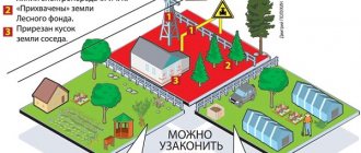
- The declared land plot cannot be registered in the cadastral register under the current legislation (for example, forest fund lands, etc.).
- The applicant is a person who does not have rights to the claimed land plot.
- The applicant has disputed rights to the said land. For example, if other citizens claim the allotment on equal rights (children, tenant, heirs, etc.).
- The site crosses the territory of a government agency.
- The site extends beyond the boundaries of the populated area or crosses its territorial border.
- The plots that were merged have different land categories. In order to seamlessly combine plots, the same category of each of them is required.
- The unified register contains other information regarding the claimed land plot. For example, if its area is significantly smaller or larger than indicated in the register. The maximum permissible error is 10% of the declared area.
- The site is not equipped with an entrance or passage, namely the absence of an easement. This is a special agreement between the owners of neighboring plots, according to which the landowner, who does not have his own access to the plot, has the right to limited use of someone else’s territory to ensure access. The passage should be no narrower than two meters.
Some of these grounds can be corrected. After correcting the reason for refusal, you can submit documents again. If the refusal is unlawful and you have evidence of illegal actions by employees of institutions, contact the judicial authorities to assert your rights.
Not every violation can cause a refusal. Some minor discrepancies become grounds for suspending the assignment of a cadastral number. If such a decision was made, the situation can be corrected and the registration can be resumed within a year.
The following grounds are possible for suspending the assignment of a cadastral number:
- The boundaries of the registered plot are superimposed on the territory of the plot, which is already registered in the cadastral register in Rosreestr.
- Technical error by institutional staff.
- Inaccurate information provided about the land plot.
- The documents were not provided in full.
In the first case, it may be possible to eliminate the error by contacting the landowner of the neighboring plot with all the documents. It is likely that incorrect data was entered into the register. If everything is done correctly, then repeated surveying will be required to accurately set the boundaries.
When an error is made by Rosreestr or MFC employees, it can be corrected upon application. If the institution refuses to correct your information, you will have to go to court to protect your rights and interests.
If you have any difficulties obtaining a cadastral number for a land plot, contact a lawyer for advice. Free legal assistance can be obtained on our website. Ask a question to an expert in a special window.
As a rule, employees of institutions do not bring conflict situations to court. Most likely, the issue can be resolved without going to court.
Why is a cadastral passport important?
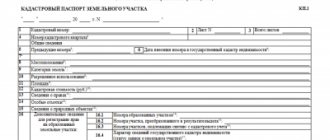
Any change in ownership rights to the selected plot, be it a desire to buy, sell, donate or exchange land, requires the owner to have a cadastral passport. This document contains the cadastral registration code of the selected land, information about the owner and the form of ownership, if any, information about the legality of the owner’s rights. The document consists of four main sections B.1 – B.4, each of which contains its own type of information.
Form B.1 allows you to find out basic data, namely:
- area, category and intended purpose of the land - individual housing construction, agricultural land and others;
- cadastral number and cadastral value assigned to the land plot;
- information about the owner or possessor.
Form B.2 is a drawn plan for the land. It is issued only if land surveying has been carried out. Resolutions, clarifications regarding the use of land, all possible restrictions and encumbrances are indicated in forms B.3 and B.4. As a rule, they contain information about the location of utility networks or an environmental zone. If there are none, forms B.3 and B.4 are not issued.
How to assign a cadastral number to a land plot
According to Part 6 of Article 120 of the Land Code of Ukraine, an essential condition of an agreement providing for the acquisition of ownership of a residential house, building or structure is the cadastral number of the land plot, the right to which is transferred in connection with the acquisition of ownership of these objects. The assignment of cadastral numbers to already privatized land plots under the existing state act of the “old model” occurs on the basis of technical documentation on land management, as well as by entering information about the land plot into the database of the automated system of the state land cadastre.
Obtaining a cadastral number of a plot of land
Having a title document in hand, the owner often does not know where to start or where to get a cadastral number for the plot. First he must come to an organization engaged in geodetic work. It is advisable that this company be located as close as possible to the property in question. Here he expresses in writing his desire to survey the land.
The cadastral specialist will carry out all the necessary measurements of the site, mark its boundaries, and officially record the coordinates. As a result, a whole package of documentation will be developed, which is called land surveying.
Next, the owner needs to collect the following package of documents necessary to issue a state number to the site:
- Any document confirming the legal right to land;
- An act of coordination of the extreme lines of the site with neighbors;
- Cadastral plan (provided in text and topographic format with the obligatory presence of information about the turning points of the plot);
- Passport of the citizen who submits the application. If this is done by the owner’s representative, a notarized power of attorney is required;
- Statement of desire to register a plot of land;
- Paid receipt.
It is best to contact a nearby multifunctional center with this list of documents. Take a ticket with the queue number and after the call go to the indicated window of the MFC specialist.
After all these manipulations have been completed, the land owner receives a receipt with a list of documents received and an indication of the date of the return visit to the office.
The MFC specialist transfers the received documentation to the registration authority, which records the changes associated with the site in the electronic list of information, and then reflects this data on paper. When performing these works, it is customary to be guided by the rules and regulations of Federal Law 221.
In order to correctly draw up property documentation, it is necessary to assign a unique cadastral number to the plot. It is recorded in accordance with the already established numbering of plots in the specified cadastral quarter in such a way that the number is not repeated anywhere else. Now this land will always be considered under this number.
In the event that a division, merger, or seizure of a plot of land occurs, the outdated cadastral number is moved to the archive along with old information regarding the characteristics of the plot. As a result of the above-described manipulations with the land, new cadastral numbers are issued to the plots. After completing a sale or purchase or any other type of alienation, the existing cadastral number will be transferred to the new owner.
So, after the relevant data has been recorded in the records, the real estate cadastre engineer prepares for issuance the relevant documents officially confirming the rights to the land - an extract from the Unified State Register of Real Estate and a land cadastral passport. A similar procedure will be required when obtaining a cadastral number through State Services.
The time it takes to complete the entire registration procedure is usually 21 days.
From the above it follows that obtaining a state number for your plot is quite simple. After its appropriation, the owner has the right to any transactions with land - sale, donation, leaving it as collateral in the bank, receiving full information about his allotment. And in extreme cases - receiving compensation for the site.
Receipt procedure
Documentation
To obtain a cadastral number, you first need to prepare the necessary documents :
- a certificate confirming land ownership or an extract from the Unified State Register of Real Estate;
- a document that is the basis for acquiring the right to use real estate (this can be a purchase and sale or lease agreement, a certificate of inheritance, a deed of gift);
- if the land ownership is located on the territory of a gardening association, a certificate of membership in this association will be required;
- if you need to rent an object from the state or municipality, you must obtain the written consent of the municipality and other tenants, if any;
- when one of the owners is a minor, it may be necessary to obtain the consent of the guardianship authority;
- a duly certified certificate of assignment of an identification code;
- technical plan;
- boundary plan;
- identification document of the interested citizen (civil passport.
The technical plan and the surveying procedure can be ordered from a geodetic company , making sure that such work is permitted by its license.
In certain situations, the owner of the land does not have the opportunity to act personally for himself. In such cases, according to the described procedure, a representative may act on his behalf, for whom it is necessary to issue a power of attorney certified by a notary.
Read more: Application to change the defendant in civil proceedings
Where is it issued?
A cadastral number can be obtained by submitting a package of documents to the local branch of Rosreestr or to the MFC .
A prerequisite is preliminary land surveying; to carry out this procedure, you will need to contact a geodetic company.
An agency official will ask the applicant to complete an application, also called a request.
Then the citizen must be given a receipt for payment of the state duty. Its size today is 200 rubles .
An employee of the institution takes the documents, in return for which he gives the applicant a receipt. It must contain a list of all transferred papers, as well as the date when you can pick up the extract with the cadastral number. If you submit an application through the MFC, you can receive the finished document there.
Starting from 2020, cadastral passports are no longer issued as they have been abolished. Now the applicant is given a single extract from Rosreestr.
Deadlines for preparing an extract
If there are no errors or inaccuracies in the documents, the extract will be made within 21 working days . If inconsistencies are found in the papers, this can greatly delay the procedure.
The finished extract with the cadastral number looks like this:
Online issuance
Today such an opportunity exists. To use it, you need to go to the Rosreestr website by entering https://www.rosreestr.ru in the address bar of your browser, and then going to the “Individuals” section (for citizens).
In the window that opens, on the right we find the link “State cadastral registration” and follow it.
In the form that opens, mark the items we need and move on, following the instructions displayed on the screen.
After completing all the steps (there are 4 in total), an application will be submitted to register the land plot for cadastral registration.
When the documents are ready, they can be obtained at the applicant’s choice:
- as a link to an electronic document;
- in the form of a regular paper document (in the division of the body for registration of rights, in the MFC, or by sending by mail).
You can get an extract for an already registered object by selecting the corresponding command on the right side of the window in the previous screenshot (it is the top one in the column). A page will open with a form to fill out, where you must enter the relevant information.
Next, you should go through 3 more steps, following the instructions.
After completing the form and confirming the entered information, the request is sent for processing.
Depending on the user's choice, the finished statement will be received :
- as a link to an electronic document;
- to the e-mail address.
How to find out the number by address
Each CN corresponds to only one piece of real estate, so you can get information about its number by looking at the address. You can find out the KN of a land plot by address in several ways:
- by contacting Rosreestr;
- on a public card;
- for the territory surveying project.
To receive a CN at an address, you need to contact the Rosreestr department or any MFC with a passport and request background information about the site number.
In Rosreestr branches the service is provided free of charge; in MFCs standard fees approved by the regional government may be charged (within 200 rubles).
To determine the CN at the address of a plot of land, you need to perform the following steps:
- go to the public map website;
- select and zoom in on the desired region of the Russian Federation;
- find on the map of the region the settlement or area in which the site is located;
- In the upper left search field, enter the location address and click the “Find” icon;
- The cadastral number of the selected plot will be displayed in the window on the left.
When you enter an address, the site will begin to suggest addresses from the database of that area. You can only specify the street and select the desired house from the drop-down list on the left.
If the plot belongs to a garden or country house, then information about the number can be found on the land surveying project , a copy of which is available on the partnership board. The original survey project is kept in the archives of the local municipality.
Read more: Call to work due to production needs