What it is
The addition of a land property is considered to be an increase in the boundaries of the existing area through the unauthorized annexation of adjacent territories.
Considering that the number of unauthorized lands was rapidly increasing, the Russian Government adopted amendments to the Land Code of the Russian Federation, which came into force on March 1, 2015.
They introduced into legislation the concept of redistribution of land territories, that is, the addition of land legally.
Thus, any person who has an allotment received or acquired for vegetable gardening, horticulture, agricultural activities, or the construction of a personal home has the right to apply for the legalization of municipal territory.
Please note: The rules of redistribution are regulated by Art. 39.29 of Chapter 4 of the Land Code of the Russian Federation.
What to do if the area has increased during land surveying
What to do after land surveying? Upon completion of the preparation of the boundary plan, you need to register the result of clarifying the location of land ownership boundaries in Rosreestr - submit documents for making changes to the Unified State Register of Real Estate. This can be done by the owner or the cadastral engineer himself.
- the landowner applies to the authorized body with an application for the redistribution of plots in private and public ownership;
- the authority sends him consent to such redistribution if there are no grounds for refusal (the land has not been withdrawn from circulation, not provided to another person, etc. - a total of 13 grounds for refusal);
- the applicant hires a cadastral engineer to record the resulting lands and registers them in the Unified State Register of Real Estate;
- a redistribution agreement is signed, which specifies the fee for which the lands are transferred from public to private ownership.
Interesting read: How to find out the address of the owner of the house
How to add land to an existing site
The redistribution of territories is carried out through the consistent implementation of measures, the implementation of which can guarantee a positive result:
- Drawing up and submitting an application. It should contain the following information:
- passport details of the applicant or details of a legal entity;
- cadastral numbering of land areas involved in the addition;
- information about the land surveying project (if it will be carried out on the basis of the project);
- contact details of the person applying.
- Preparation of the necessary documentation. Send it along with the application to the local municipality. Papers can be sent electronically or on paper.
- Consideration of the appeal and making a decision on it. In the absence of violations of the requirements established by land legislation, a decision may be made to approve the land layout plan. In this case, the applicant is sent approval for the execution of an agreement on the annexation of additional land based on the survey project. Municipal authorities may refuse to redistribute land for the reasons established in paragraph 9 of Art. 39.29 of the Land Code of the Russian Federation.
- After receiving approval, the person ensures that the necessary work is carried out to account for the land objects created as a result of the increase. To do this, you must contact the cadastral chamber with a corresponding application.
- Within one month, an agreement on the accession of additional space is prepared and sent to the applicant for signatures. This must be done no later than thirty days.
- The signed agreement must be submitted for registration to Rosreestr and an extract from the unified register must be obtained confirming the owner’s rights to the newly formed plot.
Lawyers recommend knowing what the inventory value of an apartment is.
Who can benefit from redistribution?
In most cases, this procedure applies to citizens who own a plot for individual housing construction (IHC), personal subsidiary farming (LPH), gardening, dacha farming or vegetable gardening.
Land legislation also provides grounds for redistribution for the development of built-up areas in order to bring the land into compliance with the approved land surveying project.
They also use this opportunity to build facilities, seizing land for state or municipal needs.
How many acres can be added to a plot of land?
free of charge without bidding if this “additional” share is of a size not exceeding the minimum size of the plot determined for objects of a specific purpose. This rule is provided for in Art. 27 of the Law “On the State Real Estate Cadastre”.
For example, for the construction of dachas in the main part of the subjects of the state, a standard territory size of 6 acres is provided. Therefore, it will be possible to legalize no more than 6 additional acres.
But for the area for individual housing construction, no more than 3 acres are allocated, and it will be possible to increase it only by this amount, which is actually already used.
It is worth noting: the minimum sizes of plots are determined by regional standards and the legal framework of local authorities. If such norms are not adopted, then no more than 10 percent of the area is allowed to be connected free of charge.
The procedure for cutting off a land plot and the cost of registration
- You should start by consulting with cadastre engineers, who will assess the situation regarding the cut-in. They will begin preparing a layout plan for the facility, in the absence of a land surveying project. At the same time, the extension territory cannot violate the requirements of civil, land and other legislation. At this stage, the existence of easements, third parties having the right to this territory, etc. is clarified;
- Submitting an application for redistribution of plots;
- The owner's application is considered for about 10 days, during which the authorities are obliged to identify the grounds for refusal.
Also read: Car Taxes in the Chernobyl Zone
The person receives notification of the result of consideration of the application for an increase in the form specified when submitting. If a positive result is issued, the applicant ensures the cadastral registration of all new properties that appeared as a result of redistribution. The redistribution agreement is signed within a month after submitting the application.
Land redistribution scheme - example
Let's give some example. The owners of adjacent lands in the village of Pavel and Peter turned to the land management organization to conduct a cadastral survey, prepare and carry out boundary work of their territories, without revealing the true motives.
After paying for the work and receiving ready-made documentation, the men prepared and submitted to Rosreestr an application for registration of the areas, while redistributing them. Within the prescribed period, they were given a refusal, since the new areas did not meet the requirements of land legislation and by-laws of municipal acts.
It turned out that during the redistribution, the territory of Pavel was significantly reduced, and this cannot be done, since a residential building was erected on it, and the area under it cannot become less than 0.6 hectares.
Subsequently, the men had to re-apply to the survey organization to conduct a repeat topographic survey, taking into account the established requirements. And then they were given new documentation for their plots.
We draw up the addition of a land plot: procedure, terms, cost of the service
You can find out the cadastral price from the Public Cadastral Map available on the Rosreestr web resource. To obtain information you need to know the address and the plot number. It is also possible to send an electronic request to Rosreestr. A response from the department should be expected within five days after submitting the application.
The cost of an addition to a land plot is determined exclusively by the owner of the land - in this case, a subject of the federation, the state, or a municipal entity. To the question “how much does cutting cost?” It is difficult to answer unequivocally, since much depends on the ownership of the plot.
Sample application for redistribution
The appeal is in a simple written format and must include the necessary information.
It should be noted that only neighboring lands can take part in the cutting procedure, and they must meet certain requirements.
To implement it, the consent of all owners of the territories, drawn up in writing, indicating information about the participants in the process and the essence of the issue, is required. The process of land redistribution is quite simple, but it takes a long period of time spent on paperwork.
Watch the video that explains how to attach a plot of land to the main one:
How much land can be added to the main plot
The amount of the additional fee is equal to 15% of the cadastral price for the municipal plot, which becomes the property of the citizen (clause 3 of the Rules for determining the amount of the additional fee, approved by Resolution No. 1308). The cadastral value can be found out from the cadastral passport of the land, from the local administration or from the public cadastral map of Rossreestr.
Aivazovsky turned to a lawyer to clarify how to register an addition to a land plot in 2020 . Having received the necessary information, the citizen wrote an application for the addition of a municipal allotment and submitted it to the city administration for land issues. Along with the application, a copy of the title document for the land owned by Aivazovsky was presented.
27 Jun 2020 stopurist 2044
Share this post
- Related Posts
- Monthly allowance for 2020 for the third child
- Pristova Immediately Take Things Away Lidovit Term
- From What Amount Can Bailiffs Seize
- After What Period of Non-Payment for Utilities
How to add ownerless land to your plot
Acquisitive prescription means that a person who is not the owner of the property, but who conscientiously, openly and continuously owns real estate as his own for fifteen years, acquires the right of ownership of this property (acquisitive prescription).
We bought a plot of land. Immediately behind it there is a plot of ownerless land (about 6 acres), 15 meters long and exactly as wide as our plot (about 40 meters), i.e. This land looks like a logical continuation of our site, but is not formalized in any way. Behind the ownerless land runs a stream, behind the stream there is a neighbor's plot, fenced off from the stream by a fence. There is no access to the abandoned land on either side, because... It is surrounded by a stream on two sides, a neighbor’s fence on the third side, and our property on the fourth. In fact, we use this land for a vegetable garden, but I would like to formalize it.
What to do if the land plot is actually larger than according to the documents
When re-registering “additional acres” in your name, you should take into account the legal nature of these lands. Is it possible to obtain private ownership of this plot of land? This is the question every land user should ask when registering their rights to the “extra acres.” The Land Code contains a rule limiting the turnover of a certain category of land.
There are often cases when lands from the forest fund are adjacent to dacha plots. Taking advantage of the situation, citizens are taking over forest lands. Despite this, the Forest Code prohibits the registration of ownership of such lands. In this case, the length of time the land is in the use of the summer resident does not matter. It should be borne in mind that Article 71 of the Forest Code of the Russian Federation allows for the provision of land from the forest fund for free use for a certain period and for lease .
26 Jun 2020 glavurist 304
Share this post
- Related Posts
- What are the Documents for Tax Deductions When Buying an Apartment in 2020
- How to Check Ownership of an Apartment
- Sample application to founders for dismissal of LLC director
- Application for transition to the simplified tax system from 2020
How to register an adjacent land plot as property
But there are also caveats. It is important that the land is not privately owned and under encumbrances; in addition, local authorities have the right to legally establish additional restrictions on the size of the addition of land plots.
Adding a land plot to the main plot in 2020, design features
Please note that the described procedure refers to the 4th basis, that is, the addition to a plot of individual housing construction, private household plots, vegetable garden, gardening, in the absence of an approved land surveying project. 1st stage. The first step is to prepare a layout diagram of the land plot. You can prepare the diagram yourself.
If the decision of the authorized body is positive, the citizen must organize and pay for the work on cadastral registration of all land plots that are formed as a result of redistribution (Clause 11, Article 39.29 of the Land Code of the Russian Federation). As the Ministry of Economic Development of Russia explained to the GARANT.RU portal, we are talking not only about a plot that belongs to a citizen and whose boundaries have been expanded, but also about state (municipal) land, due to which such an expansion took place. At the same time, such work will have to be paid for regardless of the area of the state (municipal) site used for redistribution. “The cost of a cadastral engineer’s services varies greatly depending on the complexity of the work and the region where it is performed. For example, in the Mozhaisky district of the Moscow region, registering a plot of land with cadastral registration will cost approximately 10 thousand rubles, and in the Leningrad region - already 30 thousand rubles. These expenses are an inevitable payment for the applicant for the opportunity to legally increase the territory and acquire land ownership on preferential terms,” notes Alexander Agafonov.
Land payments
According to the legislation, Decree of the Government of the Russian Federation dated From here we can conclude that information on land reservation should be displayed on the Public Cadastral Map. However, given how our laws are implemented, it would be reckless to rely solely on Rosreestr and the PKK. The availability of an announced auction can be checked on the torgi website. You can determine the presence of decisions on preliminary approval in 3 ways, which I showed in 2 videos.
A complete list of options to increase your summer cottage plot at the expense of adjacent lands
If you have received a positive decision and an approved scheme, then you can move on to the next 5th stage. The administration sends this consent if you have declared the redistribution of the site on the 3rd basis, that is, in the territory where the land surveying project has been approved. Since we are considering the procedure for cutting off land according to the 4th basis, that is, for plots of private household plots, individual housing construction, vegetable gardening and horticulture, where there is no approved land surveying project, we will not focus on this point.
- an extract from the Unified State Register of Real Estate for land;
- a copy of the title document for land ownership (certificate of state registration of rights);
- a copy of the documentation on the basis of which the property belongs to the owner (various contracts, certificates of inheritance, acts of state and municipal bodies, etc.);
- a project to survey the territory within which the land is located. In its absence, a layout diagram of the site being formed is attached to the project;
- identification document of the applicant.
Thus, the procedure for annexing land is understood as the process of adding plots to the territory belonging to the owner, carried out in accordance with the provisions of the law.
Definition
- when it is necessary to build up and improve an area requiring development;
- when the construction of capital buildings is required;
- if necessary, cultivation of vegetable and fruit crops on a site located in SNT;
- in the case when the landowner wants to build a private household or start running private household plots.
A request on a cadastral map can be made by entering the coordinates of a specific area or its cadastral number. In the latter case, you will not even need to obtain an address, since the cadastral number is unique.
It is also prohibited to redistribute land plots located in or between each other and with the lands of private individuals, except in cases where this is necessary to change the cadastral plan of the general territory, for example, during development. Otherwise, the contract will be declared invalid.
Cutting off a plot of land - latest news
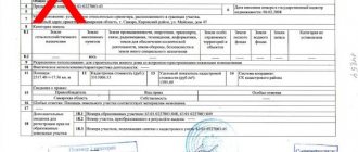
To register the concluded agreement, the following documents will be needed: the owners’ decision to carry out redistribution; title papers for plots; cadastral passport for the land plot; identification document of the applicant; protocol for making a decision on concluding an agreement; a statement from one of the participants in the procedure (you can view and download it here: []); agreement on redistribution of land plots;
And such work is carried out at state expense. The law will come into effect 90 days after its publication and will allow owners of land plots to register surplus land in use. Amendments to the Federal Law “On Cadastral Activities” will remove barriers to complex cadastral work.