Home / Land, dacha, construction / Documents and legislation / Land plot / Categories and VRI / Individual housing construction
Back
Published: 02.22.2018
Reading time: 7 min
0
1743
Owners of land plots may be faced with the need to attach a SPOZU, or a diagram of the planning organization of the land plot.
- SPOZU for individual housing construction: concept and definition
- Requirements for SPOZU for individual housing construction
- Self-preparation of SPOSU
- Individual housing construction projects
It is required to begin construction work, to carry out additional architectural work, to reconstruct a residential building and buildings, to make changes to the house design during the construction phase.
What is a land planning organization scheme?
In short, this is a paper that contains information about those objects or structures that have already been erected and still exist on the plot of land we are considering or are planned and will be built in the near future. In other words, the SPOSU simultaneously combines real objects plus designed structures , resulting in a clear composition of structures, on the basis of which one can assess the possibility of implementing the plan and what it will roughly look like. If the plot of land has not yet been developed, then the SPOZU acts as a graphic plan , according to which buildings will be located in a certain place in the future after construction is completed.
What requirements does the legislation put forward before you start preparing the SPOSU?
- It is necessary that the plot of land undergo a land surveying procedure.
- In addition, you will need to hire specialist surveyors and conduct topographic surveys.
SCHEME OF LAND PLANNING ORGANIZATION (SPOS)
The land plot planning organization scheme (LPOSU) is a document reflecting all finished objects or structures under construction on a plot of land with reference to communications. If the owner decides to plan a personal plot, then the presence of such a scheme will become a necessary condition.
The document is needed in order to obtain permission to construct an object and it is submitted along with an application for permission to develop a land plot. SPOZU is a topographical document with survey on a scale of 1:500 and reference to underground utilities.
inexpensively and efficiently provides services for drawing up a plan for the organization of a land plot, the price for the service is low, and you can order it by calling our specialists. We employ only highly qualified engineers with extensive practical experience.
SPOSU and its contents
The schema contains several required parameters:
- data on the planned object;
- number of the land development plan;
- parameters of the site indicating the area;
- object parameters (number of storeys, height, area);
- fencing characteristics;
- symbols.
When is a planning organization diagram needed?
The document is required in several situations:
- the beginning of construction of an object (structure or building);
- making various important architectural decisions;
- modernization of the facility or its reconstruction;
- when changes need to be made to the construction plan.
The parameters of the object under construction or planned for construction are taken as initial data: number of floors, area (living and usable), height, etc., information about the boundaries of the site and topographic survey.
All information must be processed by a professional, knowledgeable cadastral engineer with sufficient experience and skill, who will take responsibility for the correctness of the document being drawn up and the accuracy of all calculations.
The quality of planning of a plot of land will directly determine the speed of collecting the necessary papers for issuing a building permit, and the amount of time that the customer of the service will spend waiting for this permit.
The finished planning organization diagram contains basic important information about the existing building or object that is planned to be built. Such a document must be available to all developers working in the legal field. The scheme has legal force, so it is often used to achieve various goals.
The land owner can order a plan for the organization of a land plot independently. Professional engineers, having received an application for a service, will draw up a document in accordance with the norms and rules of cadastral affairs.
Where can I order a plan for the planning organization of a land plot?
provides high-quality and inexpensive services for the development of a planning organization scheme for a land plot in the city of Chekhov, Chekhov district, Moscow region.
You can find out more about how to order SPOZU, the price of the service and the cost of work from our specialists. Call us and get a completely free consultation!
Why do you need a land planning organization diagram?
Only persons who have at least one of the powers included in the right of ownership (use, possession, or disposal) in relation to the plot of land on which they wish to erect outbuildings or a building for housing have the right to initiate the production of SPOZU. In the case of individual housing construction, you will need SPOZU if you:
- construction has already begun;
- want to change the project. Moreover, this can be done at any time while construction is underway;
- want to make additional changes to the architectural plan;
- Are you planning to reconstruct your residential building?
What does SPOSU consist of?
The legal requirements for SPZU are specified in special instructions developed on the basis of Federal Law No. 221, which regulates how the real estate cadastre should be carried out in the Russian state.
The most important requirement for the SPOZ is to apply directly to the topography of a plot of land a schematic plan of those objects that will soon be built on it.
Form
The type of paper sheet depicting a diagram of the planning organization of a land plot, an example of which will be clearly discussed below, consists of three main elements:
- The central part of the sheet is occupied by the diagram itself, presented in the form of a drawing.
- In the upper right corner you can see the following data, usually written in a column: Address of the site where construction is planned.
- Explication.
- Various symbols and explanations for them.
- Parameters of future structures.
Structure
If we explain what it is in simple words, then the structure shows exactly what sections the SRAM is divided into. These sections include, for example, the following:
- schematic drawing of a plot of land;
- title page;
- appendices to the SPROM, further explaining the graphically presented information.
Compound
This is a list of everything that makes up a logically integral document called a “scheme of planning organization of a land plot.” As a rule, its elements are information obtained by surveyors during their topographic surveys or taken from the cadastral register. Such elements include:
- The total area of the site.
- Cadastral number.
- Diagram of elements that are part of the infrastructure located above or below ground or on the ground.
- Number for the building plan.
- Adjacent elements of neighboring plots of land, for example, sidewalks or roads.
- Other parameters that can significantly affect future construction, for example, current legal norms require that information explaining how a private plot of land and the public territory adjacent to this plot will be exploited must be included in the plan that is being made for individual housing construction.
The cost of developing a SPOZU - a scheme for the planning organization of a land plot
| Included in the price | Price | Deadline |
| Development of SPOZU - a scheme for the planning organization of a land plot. Signing the SPOS of your digital signature using the Crypto-PRO and CryptoArm programs in accordance with the requirements of Mosgosstroynadzor (for New Moscow). | 5,000 rub. | 1 day |
INCLUDED IN THE PRICE:
- Planting a house project on a plot at a scale of 1:500.
- Calculation of technical and economic indicators.
- Signing the SPOZU of your digital signature using the Crypto-PRO and CryptoArm programs in accordance with the requirements of Mosgosstroynadzor. Requirement for sites located in New Moscow.
Requirements that apply to SPRUS
The first category of requirements that must be met includes how to correctly draw up a diagram. As a rule, it is drawn on sheets of either A4 or A3 format; if it is done on a computer, it must in any case be printed on paper; if the diagram is first drawn on paper, then it can be transferred to electronic format if desired; It is not allowed to write letters and other symbols in any way other than the printed version of their writing; to apply graphic objects, special ink should be used, and the lines should be drawn without overlaps and monolithically; There should be no corrections or typos in the text of notes or designations.
The second category of requirements that must be fulfilled relates to issues that arise between a citizen and state authorities when certifying the SPRSU. In most cases, the interested person needs to go through the following steps to achieve the desired result:
- Go to the architectural department or town planning committee or department performing similar functions in the municipal administration that is in charge of the plot of land for which the diagram was prepared.
- Give them the prepared SPOS or order its production.
- Receive it after the time required by law for verification and certification, with the necessary seals and signatures of the persons responsible for this.
What documents will the applicant need to order SPRSU, prices and production time?
You can order the production of a diagram either from the municipal administration or by submitting an application to an organization or individual entrepreneur who is engaged in the preparation of urban planning documentation or draft architectural documents.
Once the approval is completed, before starting work on the production of the SPRUS, you will need to provide :
- Your own passport or other equivalent document.
- If you are a representative of the applicant's interests, then bring with you a power of attorney that has been certified and confirmed by a notary.
- A document that proves that you have title to the piece of land for which you want to produce a diagram, or proves that you have some other right over that land, such as a right of use.
- Topographic survey of the land plot you own.
- The extract that you received from the competent state authorities from the urban planning plan.
Prices and terms
The range ranges from three thousand rubles to five to six thousand rubles paid for production in large cities in non-capital regions, and from five to six thousand rubles required to prepare a high-quality scheme in the two largest Russian cities and their surrounding areas.
The usual time period required to prepare a diagram ranges from fourteen to forty-five days. It all depends on how big the excitement is among customers at the moment, and also largely on the current season, i.e. In spring or summer, the number of people wishing to make SPOZU increases.
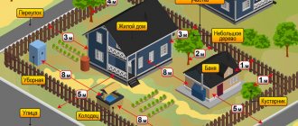
What does the planning organization of a land plot look like?
If you want to draw the SPOZU with your own hands and not pay third-party contractors, then your intention can be realized, since the law does not pose an insurmountable barrier for you, directly prohibiting non-professionals from making the diagram. The only limitation that you must consider before starting graphic work is the following question: can your future building in any way be dangerous and potentially cause significant harm to people living next to it ? If your answer is no, then you can begin to implement your plan after reviewing the example of an OPMS provided below.
What specific steps do you need to take to make your own SPOZU? Go through the following steps sequentially:
- To ensure that your diagram can be used for its intended purpose in the future, please note that under no circumstances should you change the data obtained from the cadastre about your site and absolutely any parameters reflected in the urban planning plan.
- Bring the graphical data from the urban planning plan to a scale of one to five hundred in order to copy them, or if you have a topographic survey with a scale of one to five hundred, then use it.
- You need to transfer already constructed structures onto your diagram using lines that are smooth and clear , in which there are no overlaps, only in ink with acceptable colors, namely purple or blue .
- What is planned to be built on your plot in the future must be displayed using a dashed line .
- Please clarify symbols that may be misunderstood in the notes below the diagram. In addition, it is necessary to indicate the parameters of future construction objects, for example, the number of floors, the coordinates of their location, and area.
- Data must be entered in accordance with the rules that govern the form of the SPRUS.
- After you complete this work, you will need to take this diagram to the city planning department or other government agency involved in performing similar tasks to have it certified.
- Having passed the certification stage, you can use this scheme in order to obtain permission to build objects of interest to you.
Of course, there can be no question of any SPOZU certificate if you neglected the required scale or made corrections in the drawing or text notes, or made any mistakes, for example, with the display of cadastral information.
Scheme of planning organization of a land plot
SPOZU, which stands for “Land Plot Planning Organization Scheme,” is one of the sections of project documentation necessary for effective territory planning, creating optimal relief and establishing locations for laying utility lines. The purpose of completing this document is to obtain a construction permit.
The diagram reflects:
- placement of existing and planned buildings and structures on the site allocated for development, with all the necessary distances, sizes and premises;
- routes of approach and access to the site and objects;
- plan for transport movement throughout the construction area;
- objects that should be demolished;
- site planning, landscaping, beautification;
- dividing the territory into zones;
- stages of construction.
This section should also describe technical and economic indicators that comply with established standards and requirements.
SPOZU contains calculations of the necessary indicators: the total area of the object, elevations, building area, etc.
Source data for SRAM
To implement the planning organization scheme for land plots, individuals need to collect the following documents and data:
- characteristics of existing and designed buildings and structures (number of floors, dimensions, area of the site, living area, etc.);
- urban development plan of the allocated land plot, approved and introduced in a regulated manner;
- reliable copies of documents for the real right of ownership of the territory (certificate of ownership, lease agreement, land use act, etc.);
- a copy of the registration passport of the landowner;
- topographic survey diagrams, where the boundaries of the required area are clearly marked - if available;
- photocopy of the land survey file – if available.
For legal entities, the list of documents is somewhat longer:
- application for execution of the scheme;
- a copy of the document, which is the basis for making a decision on the preparation of design and estimate documentation;
- project development assignment;
- urban planning plan;
- documents indicating ownership of the land plot;
- register passports and extracts;
- topographic survey indicating the boundaries of the site;
- certificate of state approval of rights to structures located on the territory of the facility;
- copies of passport and charter;
- completed sketch;
- completed architectural plans;
- characteristics of the location of the site and its functional purpose;
- traffic and pedestrian traffic patterns;
- expected frequency of cargo movement along future routes;
- report on the results of engineering research and testing.
Subsections of the SRAM
An ORAM section usually consists of a text part and a graphical application.
The text subsection includes:
- characteristics of the site on which the object will be built;
- justification for the layout of the land plot in accordance with established standards or documents on the operation of this territory, if it is not subject to urban planning regulations;
- motivation for determining the boundaries of sanitary, security zones, sanitary gaps in accordance with norms and requirements - if necessary;
- description of landscaping and beautification activities.
Graphic materials depict:
- locations of existing and planned buildings and structures;
- designation of existing and projected access routes and approaches to the above objects;
- limits of public easement areas – if any;
- boundaries of areas requiring special operating conditions;
- objects subject to demolition;
- decisions made regarding the improvement of the territory.
Execution Features
The composition and content of the planning organization scheme of the land plot may vary depending on the purpose for which it is drawn up.
When construction of residential real estate by individuals, the SPOZU must contain:
Information in text form:
- description and features of the land plot allocated for construction;
- justification of the limits of protective sanitary zones;
- an explanation of the scheme itself in accordance with urban planning standards;
- description of activities aimed at landscaping and landscaping;
in the form of drawings are presented:
- places intended for the placement of existing and designed buildings and structures, mark the paths of approaches and approaches to them;
- boundaries of the scope of the imposed easements - if any;
- decisions taken to improve the territory;
- boundaries of sanitary, security zones and dignity. ruptures.
SPOZU for OKS carried out by legal entities includes:
in description:
- detailed characteristics of the land plot allocated for development;
- detailed motivation for the established limits of sanitary zones;
- justification of the scheme in accordance with the regulations;
- feasibility study of SPOSU;
- thorough argumentation of the adopted technical and technological decisions to prepare the territory for construction, protect the site from the negative results of natural disasters and dangerous geological processes;
- determination of vertical layout relief;
- justification of the places allocated for the construction of main and additional buildings and structures;
- decisions made on landscaping;
- description and explanation of external and internal transport routes, their technical characteristics;
in the graphic part:
- designation of existing and planned objects, roads leading to them;
- boundaries of influence of public easements;
- indication of structures to be demolished;
- organization diagram of site planning, landscaping, lighting;
- plan for developing the territory with objects (by stages);
- schematic representation of the routes for movement of construction vehicles around the site;
- displaying transport roads and connecting them to existing communications;
- earth distribution plan;
- branching diagram of engineering communications;
- a situational plan depicting the location of the facility on the territory, indicating the boundaries of adjacent lands with special requirements for use, settlements.