Architecture and urban planning are among the most ancient industrial sectors, where compliance with all legislative, technical, functional and operational standards and regulatory restrictions is mandatory.
Each nation today has its own traditions of the location and mutual localization of streets, squares and other elements of urban planning:
- In relatively new urban formations, this is generally a rectangular arrangement, where the streets are strictly perpendicular to each other and the intersections form clear right angles.
- No less often, especially in ancient cities located in warm climatic zones near trade land and waterways, a radial arrangement of streets occurs when they diverge in different directions from one center. It could be a palace, a temple, a square or a market, usually also located in the square.
It was during those times that many definitions appeared in the urban planning industry, which remain relevant today.
First of all, in addition to highly specialized terms, there are generally accepted ones that are used by literally all people, even those very far from the construction industry. This is a widely used term in completely different guises - the red line.
Despite the fact that the name is quite old, its essence has not changed at all over the course of several centuries. To know exactly the features of this term, it is necessary to consider it in theoretical and practical aspects.
What is a red line in construction?
The construction and development of the architectural industry involves a variety of interpretations of the names used and considers the concept of the red line as follows:
- As a certain designation of existing, planned, changed, newly formed boundaries of the territory for general use.
- In addition, the line can also be the boundary of a land plot on which power lines, communications, various linear cable structures and structures, and pipelines of various purposes are located.
- It limits the network of highways and highways, railway lines and other similar linear structures.
- It separates the public and public parts of the territories from the plots of land that are being developed by private individuals.
- In terms of documentation, the red line is approved as part of the territory planning project and is displayed on the drawing of the territory surveying project.
- General plans of the settlement, city district boundaries, zones with various functional purposes are legally defined in relation to the red lines, and the territorial zoning boundaries are established in relation to these lines.
Legislatively, this category of planning and construction was first reflected in 1998 by the Town Planning Code of the Russian Federation, and the expansion of the concept and the introduction of new features into it was made in a new edition of 2004 in paragraph 11 of Art. 1.
Today, there are several aspects of life and production activity when it is extremely important to know the features of dislocation, that is, how and where the red line runs.
What are red lines?
Red lines
— lines that indicate existing, planned (changed, newly formed) boundaries of public areas and (or) boundaries of territories occupied by linear objects and (or) intended for the placement of linear objects (Article 1 of the Urban Planning Code of the Russian Federation).
The red line represents the border separating the territory designated for general use (streets, alleys, driveways, etc.) from the territory designated for individual land plots for individual use.
The establishment of red lines is carried out through the development and approval of territory planning documentation.
More details
The preparation of territory planning projects is carried out to highlight the elements of the planning structure, establish the boundaries of public areas, the boundaries of the zones of the planned placement of capital construction projects, determine the characteristics and priority of the planned development of the territory.
The territory planning project consists of the main part, which is subject to approval, and materials for its justification.
The main part of the territory planning project includes:
1) drawing or drawings of the territory layout, which displays:
- red lines (the procedure for establishing and displaying red lines marking the boundaries of territories occupied by linear objects and (or) intended for the placement of linear objects is established by the federal executive body exercising the functions of developing and implementing state policy and legal regulation in the field of construction, architecture, urban planning);
- boundaries of existing and planned elements of the planning structure;
- boundaries of zones of planned placement of capital construction projects;
2) regulations on the characteristics of the planned development of the territory, including the density and parameters of development of the territory (within the limits established by the town planning regulations), on the characteristics of capital construction projects for residential, industrial, public, business and other purposes and the necessary support for the operation of such objects the life activity of citizens of objects of communal, transport, social infrastructure, including objects included in the programs for the integrated development of communal infrastructure systems, programs for the integrated development of transport infrastructure, programs for the integrated development of social infrastructure and those necessary for the development of the territory within the boundaries of the element of the planning structure;
3) provisions on the priority of the planned development of the territory, containing the stages of design, construction, reconstruction of capital construction facilities for residential, industrial, public, business and other purposes and the stages of construction, reconstruction of utility, transport, social infrastructure facilities necessary for the functioning of such facilities and ensuring the livelihoods of citizens , including facilities included in the programs for the integrated development of utility infrastructure systems,
4) programs for the integrated development of transport infrastructure, programs for the integrated development of social infrastructure (Article 42 of the Town Planning Code of the Russian Federation).
Order of the Ministry of Construction of Russia dated April 25, 2017 No. 742/pr approved the Procedure for establishing and displaying red lines marking the boundaries of territories occupied by linear objects and (or) intended for the placement of linear objects.
Preparation of a land surveying project is carried out in relation to a territory located within the boundaries of one or more adjacent elements of the planning structure, the boundaries of a territorial zone defined by the rules of land use and development and (or) the boundaries of the established territorial planning scheme of a municipal district, the master plan of a settlement, an urban district functional zone.
Preparation of a land surveying project is carried out for:
1) determining the location of the boundaries of the land plots being formed and changed;
2) establishing, changing, canceling red lines for built-up areas within the boundaries of which it is not planned to place new capital construction projects, as well as for establishing, changing, canceling red lines in connection with the formation and (or) change of a land plot located within the boundaries of the territory , in relation to which the implementation of activities for the integrated and sustainable development of the territory is not provided, provided that such establishment, amendment, or cancellation entail exclusively a change in the boundaries of the public territory (Part 2 of Article 43 of the Town Planning Code of the Russian Federation).
The text part of the territory surveying project includes:
1) a list and information about the area of land plots to be formed, including possible methods of their formation;
2) a list and information on the area of land plots being formed that will be classified as public areas or public property, including in respect of which reservation and (or) withdrawal for state or municipal needs is expected;
3) the type of permitted use of the land plots being formed in accordance with the territory planning project in cases provided for by this Code;
4) the intended purpose of the forests, the type(s) of permitted use of the forest area, quantitative and qualitative characteristics of the forest area, information about the location of the forest area within the boundaries of specially protected forest areas (if the preparation of a land surveying project is carried out in order to determine the location of the boundaries of the formed and (or) modified forest areas);
5) information about the boundaries of the territory for which the land surveying project has been approved, containing a list of coordinates of characteristic points of these boundaries in the coordinate system used to maintain the Unified State Register of Real Estate. The coordinates of the characteristic points of the boundaries of the territory in respect of which the land surveying project has been approved are determined in accordance with the requirements for the accuracy of determining the coordinates of the characteristic points of the boundaries established in accordance with this Code for territorial zones.
The territory survey drawings show:
1) the boundaries of the planned (if the preparation of the territory surveying project is carried out as part of the territory planning project) and existing elements of the planning structure;
2) red lines approved as part of the territory planning project, or red lines approved or changed by the territory surveying project in accordance with clause 2, part 2, art. 43 of the Town Planning Code of the Russian Federation;
3) indentation lines from the red lines in order to determine the locations of permissible placement of buildings, structures, structures;
4) the boundaries of the land plots to be formed and (or) changed, the conventional numbers of the land plots to be formed, including in relation to which they are expected to be reserved and (or) withdrawn for state or municipal needs;
5) boundaries of public easements.
The placement of capital construction projects is prohibited within the red lines.
The territory that separates the building from the red line belongs to the owner. Its name comes from the color used to indicate borders on maps. They mark the boundaries of territories and land plots. They separate areas from the following structures: power lines; gas pipelines; communication lines; roads; railway roads, etc. Privately owned areas are separated in red from public areas. Now the functions of the red line have been expanded and include determining the permissible proximity when land plots are adjacent. The distance is also taken into account when constructing residential and other buildings on a site that is privately owned.
The essence of the red line is absolutely the same as the essence of the border of the land plot. But the red line has stronger legal force than the usual land boundary. Only after the red line has been established is the location of the boundaries of the land plots determined. A segment of the border of a plot of land adjacent to a public area must necessarily correspond to the contours of the red line.
Red lines are mandatory for compliance by all subjects of urban planning activities involved in the design process and subsequent development and development of the territories of cities and other settlements.
Compliance with red lines is also mandatory when surveying and inventorying built-up or subject to development lands within the boundaries of a city or other settlement, when drawing up documents by citizens and legal entities for the right of ownership, possession, use and disposal of land plots and other real estate objects, their state registration.
Red lines are subject to mandatory reflection and accounting:
- in master plans combined with detailed planning projects, detailed planning projects, development projects, highway planning projects, streets and squares, territory planning projects;
- in engineering and transport communications projects;
- when establishing land use boundaries;
- in land development projects;
- in land surveying projects.
(RDS 30-201-98 Instructions on the procedure for designing and installing red lines in cities and other settlements of the Russian Federation).
When is it important to know the location of the red lines?
It has been determined that public lands are limited in circulation and cannot be made available for private ownership. In addition, the construction of new facilities and the reconstruction of existing ones must comply with the red lines. The facility under construction should not cross the red lines, and in some cases construction should be carried out with a specified deviation from them. Thus, it is important to know where the red line is when forming and clarifying the boundaries of land plots. Formation of the boundaries of a land plot without taking into account the red lines may lead to the impossibility of providing such a plot for private ownership.
To determine the calculated indicators when forming the boundaries of a land plot, when planning construction, it is necessary to correctly draw up regulatory documents. These include the following:
- Scheme of planning organization of land plots (land plot development plan) (SPOZU) is a diagram of a plot of land. It has boundaries drawn before permission is received for the construction of a building, structure or any other object. Allows you to further determine the zone permitted for construction.
- urban development plan (GPZU). It shows the red lines and overall layout in detail. Serves to carry out work on its site. Most often, a detailed plan of a land plot serves as a source of information about what restrictions there are in this area. The plan indicates high-rise buildings, parks, large complexes, squares and streets. The new object must be correctly included in this plan.
The red development line is not only the border separating private land ownership from other territories. It has another important function: before building a house or other structures, it is against it that the standards for distances between buildings and structures, as well as between the building and the border of the neighboring site, are checked:
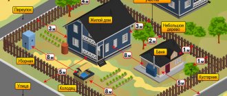
- brick houses should be 6 meters apart from each other;
- between a wooden and a brick house a distance of 10 meters is determined; log houses should be 15 meters apart from each other;
- sheds and garages can be built 1 meter from the property line.
Such requirements are determined by fire safety rules. In the event of fires at individual facilities, the risk of fire in neighboring structures will be minimized. Such distances are also justified when extinguishing fires. The need for fire trucks to approach and turn around between buildings requires certain standards.
Determining exactly where the red lines are is very important for the developer; starting to build a house without this information, the owner of the site exposes himself and his building to a certain risk. If during the construction of an object the norms for the distance from the red lines are not met, then in the future this may lead to the demolition of the construction site. To avoid such troubles, you need to familiarize yourself with the requirements of Building Codes and Regulations (SNiP). It spells out the basic rules for the proper placement of objects.
If the owner plans to build a residential building, then according to SNiP it must be located at a distance of at least 5 meters from the road and 3 meters from the street.
Housing cannot be located in the center of the site. This has a practical explanation: to fully service the building, it must be located close to the border, but no less than a meter from the fence.
Outbuildings should be located deep in the plot.
When building a garage, you need to measure the distance to the red line with the doors open so as not to violate the boundaries.
To comply with fire safety measures, the distance between houses should be from 6 to 15 meters.
Buildings for poultry and animals should not be higher than 2.4 meters in height. They can be attached to housing, but separated by three utility rooms.
How can you familiarize yourself with the passage of red lines?
You can get acquainted with the passage of red lines by obtaining Information from the State Information System for Supporting Urban Development Activities (ISOGD). This information is publicly available and upon receipt of a corresponding request, you will be provided with information about the passage of the red lines (in the form of a certificate, map fragments).
The application can be submitted by you personally or by your representative, including through the MFC, or by mail with acknowledgment of receipt, by e-mail or through the Unified Portal of state and municipal authorities.
The service is provided free of charge.
When is it important to know the location of the red lines?
When planning an individual development, you need to take into account a lot of things that will fundamentally decide the success of your project.
In addition to choosing a general architectural solution, a suitable design, orientation of the future building relative to the cardinal directions, an assortment of building and finishing materials, construction on the site of small architectural forms corresponding to the general concept and other nuances, you should pay attention to one very significant nuance.
This is the location of the future object relative to the red line, which is especially important for the following reasons:
- Construction work must be carried out in relation to the plot boundaries plan.
- When starting preliminary design, you should immediately calculate the plans of buildings or structures in such a way that the red line does not cross.
- In accordance with established standards, the plan of the future building must be located at some distance from the zone designated by the line.
In order to avoid problematic situations in the future, designers, developers and everyone who will take part in the construction or reconstruction of buildings and other objects need to approach these issues very carefully and extremely seriously.
The red building line is
Red lines are lines that are used to designate actual boundaries and those in development plans, between public land plots, between areas with power and communication lines, pipelines, highways, railway lines, etc. ( paragraph 1 of article 1 of the Town Planning Code of the Russian Federation).
Areas of settlements, streets, river and sea embankments, driveways, parks, squares and boulevards are areas accessible for use by a large number of citizens (clause 12 of article 1 of the Civil Code of the Russian Federation).
Territory planning documents contain red lines. They are also found on maps and diagrams of general development plans (Chapter 5 of the Civil Code of the Russian Federation). To determine the location of any site, red lines are used (paragraph 2, paragraph 7, article 36 of the Land Code of the Russian Federation).
The basis for determining red lines are the norms of the Civil Code of the Russian Federation and the Instructions regarding the procedure for designing and identifying red lines on the territory of any populated area in Russia.
This instruction was approved by the Resolution of the State Construction Committee of the Russian Federation in 1998 and is valid in the part that does not contradict the Civil Code of the Russian Federation.
What distance should be between houses?
Read about the rules for developing a land plot for individual housing construction here.
Read about the rules for developing a summer cottage site at the following link:
According to the Instructions (clause 3.4), red lines are used by all entities carrying out work on the construction of buildings, creating relevant construction projects, and developing territories allocated for development in various settlements.
When land surveying takes place, an inventory of lands on which various buildings have long been located, or those plots where future development is planned within a specific settlement, red lines must be observed.
The same situation occurs when individuals and legal entities prepare documents on the right of ownership, use, and disposal of land plots or other real estate.
Documents on territory planning, rules for the use of land plots, identification of part of the territory for the construction of buildings, master plans for construction also include red lines.
In cases where the rules for land use and development, as well as the master plan, do not contain red lines, there is a need for their approval. This procedure is carried out by municipalities that establish regulatory legal acts. Further, this plan must be published without fail.
How do “red lines” affect the fate of a land plot?
Compliance with the rules for localizing capital construction projects significantly influences how the further exploitation of land plots will develop.
Indicators regarding the development of the residential sector, public and business areas are determined by a document that regulates all distances and their ratio.
This is SNiP RK 3.01-01-2008 “Urban Planning”.
The document indicates that the property is not supposed to cross the border marked by the red line.
If this happens, then the building may be partially or completely located in a public area.
Which in turn very seriously affects the possibilities of further land privatization. Clause 12 of Art. 85 of the Land Code of the Russian Federation, a plot of land that is in social use is not subject to the privatization process.
The consequence is the following:
- It is impossible to privatize the land on which the real estate you own is located . Crossing the red line completely and categorically negates the possibility of ownership, even in court.
- The only solution is to rent land, but this complicates possible manipulations with the house - providing it as collateral.
Red development line: what is it? How they are located – Description
Residential and non-residential premises, streets and squares of populated areas are not installed randomly. They fit into the master plan developed by the architects and approved by the head of the local administration.
In technical documentation, the concept of “red line” is used. It is well known to the average person, but not every owner of a land plot (LP) has a reliable idea of what it is.
The designated concept in all situations of application is based on a single meaning - a border that is not crossed during the construction of buildings and transport connections.
It is determined in the context of zoning territories that divide a settlement into parts, each of which reflects its own characteristics and rules for the construction of objects.
The concept is used in the following cases:
- Determining the boundaries of the line of structures being built in a populated area, street, square, district, etc.
- Dividing the storage area into zones when drawing up design documentation or reading drawings.
- Conditional division of territory with different types of permitted use among themselves.
- Conditional separation of highways, roads, areas from other territories used for development.
In addition, it can mean the structure of the construction of a street or block and act as an organizing principle - a feature that building designers do not interfere with.
The red line concerns not only the conditions of the context of a settlement, in which the municipality and the architectural department allocate zones for the construction of high-rise buildings, two-story, three-story houses or transfer land to owners for individual housing construction (IHC).
If the territory is used for personal subsidiary plots (LPH) and is classified as agricultural land, the designated standards do not apply to it.
However, in the case of dacha land plots, there are locally developed regulations approved by the meeting of owners or the administration, if it is adjacent to a populated area.
Such storage facilities are subject to standards defining the intended uses:
- To ensure the order of public use of land property, and also to preserve the right to use land plots by each owner, without external negative influences.
- Ensure fire (and other) safety for dacha rights holders.
It determines the detailed coordinates of the permissible proximity between the owners of land plots during the construction of capital and other facilities at their dachas.
To determine acceptable standards, they present regulations on indentation standards (see What can be built in a country house and how to do it correctly).
To establish regulations and standards, regulatory documentation is required.
SPOZU – scheme of planning organization of a land plot. A red line is drawn on it, prior to the construction of the facility, separating the area where the buildings will be installed.
GPZU is an urban planning plan for a land plot, which defines the red building lines in detail. In accordance with them, it is permitted to begin, conduct and continue further work.
GPZU of a specific territory is carried out on the basis of an interactive map: after copying a snapshot of the projected area from it, topographic signs are applied on it, placing in their places the multi-storey buildings, sports and cultural complexes, parks, squares, streets and neighborhoods located in the area of the projected territory.
After land surveying, buyers of land plots have the opportunity to erect permanent structures, sheds, garages, and plant greenery on the site.
The red line narrows the user capabilities of the memory, following the established regulations:
- between brick houses – 6 m;
- brick and wooden house - 10 m;
- two log houses – 15 m;
- sheds, garages - 1 m to the boundary.
Inside the site, capital and utility facilities are located at the discretion of the owners. The listed standards are determined by compliance with fire safety.
They provide for the intervention of the Ministry of Emergency Situations in emergency situations and the permissibility of fire trucks approaching buildings. And also fire prevention.
Regarding the distance between the red line and boundary boundaries, the following regulations were established:
- between the house and the boundary - at least 3 m;
- between the garage and the boundary - at least 1 m.
Boundary strips are placed between areas, separating them with a fence.
This condition is mandatory, since the fence becomes a reference point for the standard distance for building plots.
The listed conditions are observed voluntarily by the owners, otherwise - by administrative decree or through the court (see Disputes during land surveying).
The definition of red lines is under the jurisdiction of urban planning departments of municipalities or architectural departments, as, for example, in Moscow.
We invite you to familiarize yourself with: Types and varieties of peony flowers with photos, names and descriptions, what types of peonies there are
Citizens who acquire ownership of land plots, before starting to organize work on land plots, are included in the urban planning plan of the region and receive a building permit with an approved project.
Without regulations and the establishment of standards by the municipality, such activities have no right to be carried out.
SPRZU and GPZU are purchased at the request of the applicant:
- In the local department of cadastre and cartography of the region in the form of an extract plan.
- From the cadastral engineer after carrying out cadastral work on the land plot.
All of the above parameters determine the regulations for the construction of buildings and other structures.
They are reflected in SNiP standards, which are taken into account when designing a territory for buildings erected on it.
These include but are not limited to:
- Article 11 of the Civil Code of the Russian Federation;
- Article 36 of the Land Code of the Russian Federation;
- Article 85 of the Land Code of the Russian Federation;
- Resolution of the State Construction Committee of the Russian Federation dated 04/06/1998 N 18-30;
The red development line is a boundary with the help of which the permissible extreme development zone in a city or other populated area is marked on diagrams and plans for the development of urban areas.
The decision to install such a red line is made by local authorities.
There are situations when the red building line can show the boundary not only from the outside, but also in some way limit enclosed areas inside the building site.
This may be the case if pipelines, power lines and other structures pass through such a development site.
...then, first of all, we mean the plot of land itself within these boundaries. Land may include areas that are owned by someone, such as private or municipal, and there are places with areas of public land.
Plots of public land also have their own owner, but are used by a large number of people. This becomes important when the owner of the plot wants to build a house on his territory.
The house should be built on his land, not on the sidewalk. When building a house, the legislation provides for the concept of a red line; it is on this concept that the requirements for choosing a building site are based.
Such a red line is needed to determine the boundary between the site where the house will be built and other areas that are used for public purposes.
Important! The red building line shows the territory of not a single plot of land for building a house on it, but shows the border of a whole block of similar plots. The territory is delineated in such a way that plots of land are located inside the enclosed territory, and behind this contour there is a public area.
Such a red building line is usually drawn when high-voltage transmission lines, pipelines, gas pipelines, heat pipelines and others pass through a plot of land. Construction is prohibited inside such areas.
These lines began to be called that because they are drawn in red on urban planning documents. When the authorities decide to draw such red lines, they take into account not only what currently stands, but also what can be built on this territory in the future.
In what places a residential building or other outbuildings can be built is determined by various building codes, regulations, and on the basis of the Russian town planning code.
This means that you cannot build a house or other structure in absolutely any place inside one piece of land. Let's take a closer look at the legal requirements.
Previously, there were situations when citizens first built a house or other buildings on a piece of land, and only then went to local authorities to legalize it. And local authorities treated such situations quite leniently, even if the rules for applying the red line were violated.
Therefore, it is important to choose the right sequence of actions. First you need to collect all the basic documents, which will indicate the location on which the house and outbuildings will be built.
With these documents you need to go to the local authorities to obtain permission. After this, you can begin building a house or building, since you will have documents in your hands in accordance with the requirements of the law.
Also, during construction, one should not forget about fire safety standards, according to which there is a strictly defined distance between houses on adjacent plots of land.
If urban planning standards are violated during the construction of houses and outbuildings, various situations are possible.
Let's consider the cases that occur most often:
- – if the construction of a house or other building was carried out in violation of the required standards, then such development may be considered illegal if the building lines are violated;
- – also, if the neighbors prove that your construction of the house caused damage, that is, they were not able to fully use their own plot after this, then a lawsuit may begin, as a result of which some buildings may be declared illegal and subject to demolition, or by a court decision you must will pay the plaintiff monetary compensation for damage;
- – you also need to take into account the fact that even if the norms of the construction law are not violated, there may be inconsistency of buildings between neighboring areas. For example, an owner wants to build a bathhouse on his property in a certain place, and his neighbor will build a toilet on his property nearby. In this case, the rules of the law have not been violated, but when planning the construction of your house or bathhouse, you need to take into account the possibility of such inconvenient moments;
- – it is possible that when building a house on your own site in accordance with all the norms of the law, taking into account distance standards, the roof may be positioned in such a way that it will interfere with someone else’s site or snow will fall from it onto the neighboring site. This will be a violation and may result in a fine.
The need to take into account the location of “red lines” during construction
Why is it so important to take into account the location of the red line grid and its location on the terrain if the proposed construction will be carried out in areas remote from the city?
After all, most of the plots of land that are offered for individual development these days are located at a great distance from city streets and may at first glance seem completely unimproved.
The need for construction planning is as follows:
- It is unacceptable to locate buildings within the red line.
- Control is carried out by the norms of permitting documents for development, which clearly define the scheme and plan for working with the land plot.
- At the same time, the scheme regulates the boundaries of the site, its relationship to the red line and the actual location of the proposed object.
If the red line crosses a building
This situation is possible when planning the reconstruction or expansion of streets or roadways in old areas of large cities.
At the time of commissioning, which could have been from fifty to twenty years ago, the red line was located within slightly different limits.
Therefore, renovation and other work lead to the fact that the new line may well cross one or another building or structure.
The document stipulated the inadmissibility of infringing on the right of the building owner to acquire his property under these conditions. In the vast majority of cases, the courts are on the side of the owner of the capital facility.
What is the “red development line” (RDL)
The designated concept in all situations of application is based on a single meaning - a border that is not crossed during the construction of buildings and transport connections.
The concept is used in the following cases:
- Determining the boundaries of the line of structures being built in a populated area, street, square, district, etc.
- Dividing the storage area into zones when drawing up design documentation or reading drawings.
- Conditional division of territory with different types of permitted use among themselves.
- Conditional separation of highways, roads, areas from other territories used for development.
In addition, it can mean the structure of the construction of a street or block and act as an organizing principle - a feature that building designers do not interfere with.
The red line concerns not only the conditions of the context of a settlement, in which the municipality and the architectural department allocate zones for the construction of high-rise buildings, two-story, three-story houses or transfer land to owners for individual housing construction (IHC).
Such storage facilities are subject to standards defining the intended uses:
- To ensure the order of public use of land property, and also to preserve the right to use land plots by each owner, without external negative influences.
- Ensure fire (and other) safety for dacha rights holders.