Home / Land, dacha, construction / Documents and legislation / Land plot / Land surveying
Back
Published: 01/09/2018
Reading time: 5 min
0
952
Land delineation is carried out with the aim of establishing and officially confirming all boundaries of the property. This measure helps to prevent potential encroachments on an unmarked plot by neighbors, to divide a plot that was inherited, etc. Since 2020, the land surveying procedure is mandatory if the owner intends to carry out any transactions with the land: sell, donate , exchange, inherit. What documentary base is prepared for land surveying procedures?
- List of necessary documents for land surveying: where to get them?
- What documents will be needed if the plot already has a cadastral number?
- What is a “power of attorney for land surveying”, and how to draw it up correctly?
Legislation on land surveying
The functioning of land real estate surveying activities is carried out under the application of the following legislative acts of Russia:
- “On the state land cadastre.”
- "On land management."
- “On the State Real Estate Cadastre” Order of the Ministry of Economic Development of the Russian Federation (Ministry of Economic Development of Russia) dated January 25, 2012 No. 32.
- And others.
- It is also necessary to follow the “Instructions for land surveying” dated April 8, 1996.
The current legislation takes a thorough approach to this process. If there is non-compliance with the laws, then all activities related to and carried out with the plot of land may be declared invalid. Carrying out land surveying may enable the owner of the plot to conduct land use of personal property at his own discretion.
The main rules that apply to this event are the same throughout Russia, however, their sequence may change. In larger cities, the delimitation of territory is a little more complicated compared to nearby provincial cities. In order to correctly identify the boundaries of a land plot, you should use the services of the territorial branch of the state register and obtain the necessary information there according to the specified procedure.
Identifying the lower and upper boundaries, size and location of the site cannot be done on your own. All of the above procedures have the right to be carried out only by those individuals and organizations that have a license to conduct relevant activities in the field of geodesy and cartography. The cost of the land surveying process is individual for each specialized body. The price depends on several circumstances, one of which is the region where the events are held.
How much does a land surveying plan cost?
The price depends on how many areas will be used and how much work will be performed. How much does a land surveying plan cost:
- One plot – amount from 6 thousand rubles.
- Allotment area up to 4 thousand m² - amount from 6 thousand rubles.
- Registration of rights – amount from 9 thousand rubles.
- Preparation of documentation – amount from 14 thousand rubles (this includes registration).
- Shooting of clothes - amount from 14 thousand rubles.
The amount of shooting depends on the scale of the typographic image and how much land it covers.
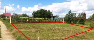
New land owners often require land surveying . This is the name of a set of works to determine the boundaries of a land plot within an area, establishing its size, area and geographical location.
Expert opinion
Kurtov Mikhail Sergeevich
Practitioner lawyer with 15 years of experience. Specializes in civil and family law. Author of dozens of articles on legal topics.
Land surveying is sometimes necessary for legal registration of land ownership, its cadastral registration with government agencies, as well as for the construction of a house.
This is important to know: Cadastral value of a property: how to calculate, what it affects
How and when does the land surveying procedure take place?
Carrying out boundary measures regarding land plots should be carried out by specialized organizations that are equipped with the appropriate permits for this type of activity. Information regarding whether any authorities have permission to conduct the land surveying process can be found on the official website of the cadastral service.
During the procedure under consideration, the following list of works should be carried out:
- verification work is carried out with documents for the agricultural plot and their compliance with the specified parameters;
- design documentation for land surveying is created;
- all persons involved in the specified process are notified, and confirmation is also attached in the form of appropriate notifications;
- a visit of a cadastral worker to the place of implementation of activities is being prepared;
- the area of land real estate is measured;
- a geodetic survey of the agricultural plot is carried out, boundary signs are placed and coordinates are established;
- the size of the plot is calculated in detail;
- a land surveying plan is developed and subsequently approved;
- a land survey is being drawn up.
Upon completion of survey activities, the initiator of the application must be given a survey plan in 2 copies. The first copy must be in the Cadastre service, and the second copy must be with the owner of the land plot.
Boundary measures are provided in the following cases:
- Land redistribution. Dividing one large plot into several small ones included in it, or combining it into one large plot.
- Amendments to the delimitation of the site. This procedure is often needed by persons who purchase real estate; they need to see and know exactly how much area they can dispose of.
- Confirmation of ownership rights to the plot. If you receive a plot of land by purchase, gift or inheritance, you must make title documents for it, register it with a cadastral number and carry out mandatory land surveying.
Connection of an adjacent land plot to the main one
For example , for the construction of a country house in most regions of the country, an allotment of six acres is provided. Therefore, it will be possible to legitimize no more than this additional territory. But for individual housing construction, land of no more than 3 acres and it can only be increased by such an allotment.
What is?
Therefore, any owner of land received or acquired for the purpose of gardening, vegetable gardening, agricultural work or construction of an individual house can apply to legalize the territory belonging to the municipality.
Two neighbors, Maria and Veronica, contacted a surveying company and ordered a geodetic survey and drawing up a boundary plan for their adjacent plots, without explaining to the performers that this was being done for the purpose of further redistribution of the territory.
- registered in the state cadastre in accordance with the established procedure;
- belong to the same administrative district, because during redistribution there should be no change in the boundaries of municipal lands;
- belong to the same target category of land.
This is interesting: How to register an individual housing construction house without a building permit in 2020
List of documents
Thus, the redistribution of a land plot is a rather complex procedure that must be approached responsibly. To avoid errors, it is strongly recommended to enlist the help of a highly qualified lawyer
. This will help you significantly speed up the entire process and protect yourself from mistakes.
Attention! If you have any questions, you can consult with a lawyer for free by phone in Moscow, St. Petersburg, and throughout Russia the call is free. Calls are accepted 24 hours a day. It's fast and convenient!
The cutting of a land plot is carried out on the basis of Art. 39.29 Land Code of the Russian Federation . This procedure is available to citizens who own and use a plot of land intended for private housing construction, for gardening and vegetable gardening.
List of documents for registration
A resident of the Amur region, Mr. Semenov Valery Gennadievich, as an individual entrepreneur, is engaged in the cultivation of fruit and berry crops on his plot for the purpose of further processing them in his own canned food production enterprise. Due to the expansion of capacity, the entrepreneur needed new areas for growing fruits and vegetables. The choice was made in favor of an empty plot nearby. After studying the public cadastral map, the entrepreneur determined that the lands belonged to the local municipality. Mr. Semenov appealed to the authorized body with a request to add a nearby plot of land to his plot.
Owners of plots often declare their intention to annex additional areas related to municipal property to their territory. Lands added in this way are often called additions.
Is land surveying possible without documents?
There are cases when permitting documentation for land real estate is not issued or is lost. If this does happen, then it is necessary to prepare for the process of restoring papers, which is an activity that requires time and money.
It is necessary to submit an application to the local BTI for the issuance of parameters of the land plot, and also enter into an agreement with a specialized organization to carry out boundary work on the territory of agricultural real estate and cadastral work.
Before the land delimitation procedure, it is necessary to make a cadastral passport and resolve all possible issues with the neighbors on the site.
Restoring the package of documents and further surveying the territory may take about three to four months. Upon completion of the above procedures, documents for the property and the plan provided after land surveying must be sent to Rosreestr, which will ensure that the owner of the plot has full ownership of the land.
Sample application for land plot expansion
How to write an application to change the territory of a piece of land? A sample application is quite easy to find on the Internet. It can be downloaded without any problems from the official portal of the Multifunctional Center of any region. The form is sent to the MFC at the place of its registration.
The most popular questions and answers to them regarding the cutting of land
The procedure for increasing the territory is carried out in accordance with Federal Law No. 93, some provisions of which are called the law on dacha amnesty. This is a simplified scheme, which is allowed for plots acquired after 2001 since the introduction of the Land Code of the Russian Federation. The additional plot registered as a property under this scheme is called an extension.
This is interesting: Issuance of personal protective equipment by profession, standard standards for healthcare for 2020
The Land Use and Development Rules of your locality state that the maximum area of a plot for individual housing construction cannot exceed 15 acres. This means that you can add no more than 3 acres of land to your plot, provided that there is free land around your plot with such area. Please note. If you want to add a fairly large piece of land to your plot, then the risk of being refused increases. In such a situation, in order to increase the chances of receiving additional land, it is advisable not to attach the land to the existing plot, but to receive it as a separate plot. You can obtain a plot of land without bidding through preliminary approval. The first step in this direction is to create an Application for preliminary approval of the provision of a land plot. A bonus to the finished application is a brief step-by-step instruction. Let's consider this basis in more detail, but preliminary
Submission of papers is possible both on paper and electronically; The application will be considered within ten days after its presentation. If there are errors in the document or non-compliance with the provisions of land legislation is detected, the competent authority will return it;
How to register an addition to a land plot 2020
According to the adopted law, if during the cadastral work the engineer discovers that the customer is actually using for his needs an area larger than indicated in the documents, the excess can be officially registered for use.
The owner submits a land surveying plan and an application on the appropriate form, in which he asks to produce a new layout of the site, already with the cutting included. Local authorities within 30 days, by making a decision by the commission, approve or deny the applicant’s request.
- consider the application, make a positive decision regarding approval of the site layout;
- send the applicant a decision on approval of the scheme with an appendix;
- submit your own consent to the redistribution of land plots taking into account the territory surveying project.
Land addition - for 50% of the cadastral value
Alexander Agafonov says that in the West there is no experience in redistributing land between citizens and the state - in most European countries all plots have long been privately owned.
On March 1, a law came into force that gave citizens the opportunity to expand the boundaries of their land plots adjacent to state and municipal lands by registering “additions” (Federal Law of June 23, 2014 No.
Therefore, the concept of redistribution of land plots is the addition of an allotment on a legal basis. The Department of City Property of the City of Moscow calculates what the price will be for annexing a part to the main plot using the following formula: “Price = cadastral value of land with an increased size - cadastral value of the applicant’s property on the day he submits an application for redistribution.” The person receives notification of the result of consideration of the application for an increase in the form specified when submitting.
Necessary documents for carrying out boundary work on a plot of land
In accordance with the current land legislation, there is the following list of necessary documents for carrying out boundary work:
- Identification document of the initiator of the application. The applicant can be either an individual or an authorized person from the owner of the property with the obligatory presence of a power of attorney to apply to specialized authorities. Organizations, in turn, must have a constituent agreement of the company, a charter, a resolution characterizing the appointment of a certain person to a leadership position, as well as a document confirming the registration of the organization and the actual availability of tax records.
- SNILS (individual personal account insurance number).
- All possible documents in accordance with which the right to carry out any actions related to the land plot will be confirmed. These can be documents on inheritance, a purchase and sale agreement, exchange, donation or privatization, etc.
- A document confirming the existence of ownership rights to a land plot. Such a document is a certificate from Rosreestr or an extract from the Unified State Register of Real Estate when registering rights to real estate after January 1, 2017, which can be obtained by contacting the MFC.
- Application according to the provided sample on conducting boundary work on a land plot.
- Justification of the identified boundaries of the agricultural allotment in the form of a cadastral plan or an extract from the Unified State Register of Real Estate, including the parameters of the allotment, as well as certificates from the BTI, which will confirm the absence of buildings on the territory.
Before contacting an organization specializing in boundary work, you must collect all of the above documents, which will allow you to complete the upcoming procedures a little faster. Documents must be submitted both in original form and copies thereof.
Some owners of agricultural territories are interested in the question of what documents are needed to carry out boundary work on a summer cottage if there is a decision from the local administration on the perpetual use of the land.
Of course, if the owner of such real estate has expressed a desire to carry out demarcation on it, then he must submit to the authorized organization an application for work, as well as all documents confirming the legal ownership of the plot.
We fill out a claim for establishing the boundaries of a land plot according to the sample
- Claims for rights to land plots, subsoil plots, buildings, including residential and non-residential premises, structures, structures, and other objects firmly connected to the land, as well as for the release of property from seizure, are filed in court at the location of these objects or seized property .
- Claims of the testator's creditors brought before the heirs accept the inheritance are subject to the jurisdiction of the court at the place where the inheritance was opened.
- Claims against carriers arising from contracts of carriage are filed in court at the location of the carrier against whom the claim was filed in the prescribed manner.
- Disagreement between neighbors about where exactly the border between their plots should be.
- Reluctance of the owner of a neighboring plot of land to participate in resolving a boundary dispute.
- A cadastral error, which the owner corrected, but the owner of the neighboring plot refused to voluntarily agree on the new location of the boundaries.
Interesting: How to get income tax from buying an apartment with a mortgage
Application form, content and sample
Before carrying out the delimitation procedure, it is necessary to draw up and submit an application to the authorized bodies. There are no specific rules on how this document should be drawn up. An application is drawn up in free form, but if there is a need for familiarization, a sample of the paper can be viewed in organizations that accept such documents and will issue ready-made papers in the future.
The official websites of such institutions also contain samples and forms of the necessary applications, which can be downloaded completely free of charge.
It is necessary to remember that the petition is drawn up on A-4 paper, grammatically and spelling correctly, using a black pen.
The document must contain information about the territorial location of the land, as well as all documentation related to the site.
The following have the right to free land surveying:
- owner;
- user of land with the right of lifelong inheritable possession or perpetual use;
- a tenant who has entered into an agreement for a long term.
When the landowner learns about the complex work being carried out, he can contact the cadastral organization (the work contractor) with an application to have his plot surveyed. The application is written in free form, it indicates the address, technical characteristics of the land, information about the owner (his full name, passport details, registration, telephone, email, etc.).
This is important to know: The nuances of banning hostels in residential buildings
What documents are needed for land surveying?
Land surveying is an obligatory part of the paperwork when buying or selling a land plot, leasing it or privatizing it. It is connected with the establishment of the boundaries of the site. It happens that the exact boundaries are unknown, and the demarcation marks are set as it was convenient for the owners of neighboring lands. With the help of land surveying, these boundaries can be restored. In addition, the obtained data is compared with a map of the area and legally documented.
The same situation arises when receiving a plot of land, the boundaries of which were established a long time ago and the documents for which do not indicate its area and address. The only boundaries are the erected fence, but no one can guarantee that it is installed correctly and does not violate the boundaries.
Power of attorney for land surveying
If for one reason or another, if the owner is not able to collect documents for land surveying and participate in geodetic work, he can draw up a power of attorney for a representative (attorney) who will act as a guarantor of his property interests.
Representatives may be:
- professional lawyers;
- realtors;
- relatives of the owner of the land plot;
- acquaintances of the owner whom he trusts.
If the plot is jointly owned, on the basis of powers of attorney from the co-owners, one of them can act.
An organization or enterprise, as well as a dacha cooperative, designate an authorized employee or member of the board of SNT, who acts under a power of attorney issued by the institution. This power of attorney is approved by the signature of the head and a round official seal.
A notarized power of attorney is presented:
- individuals;
- legal entities that do not have a round official seal.
The attorney presents the documents of the principal who issued the power of attorney for land surveying. The exception is a civil passport. In this case, he requires identification of the attorney.
Survey work complements the existing documentation for the site with a survey document that reflects all the characteristics of the land plot within the established boundaries. After carrying out the cadastral work, a land surveying act and a land survey plan are drawn up depending on the required type.
Read more about land surveying in our section.
What documents are needed for land surveying?
Land surveying of real estate is carried out by land management organizations, a list of which is presented on the Rosreestr website. When signing a contract for the provision of services, it is necessary to familiarize yourself with the cadastral engineer’s license and evaluate completed orders. The registration authority will not accept a boundary plan that does not meet the requirements.
- technical parameters (area, category, coordinates);
- graphic plan;
- registration number and date of assignment;
- cadastral value;
- information about the owner;
- details of the document according to which the territory was acquired as property;
- information about existing restrictions and encumbrances (if any).
List of documents for land surveying
The owner may not have any documents, especially if the land was received a long time ago. In this case, it will take time to process or restore them. Therefore, you need to collect a package of documents in advance. If the customer considers the process of collecting certificates too complicated, he can entrust it to the authorities that will carry out land surveying. But this will increase the cost of work. When everything is ready, an application for land surveying is written and a contract for the provision of services is drawn up.
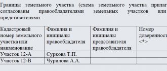
If desired, the owner can carry out the approval not at a general meeting, but personally go around all the neighbors and ask them to sign the prepared act. But if the neighbor refuses to sign for it, you will need to organize an official procedure with sending out notifications.
Nuances of paperwork for land surveying
If a citizen makes a request for land surveying not on his own behalf, but through a representative, then he will definitely need to issue a power of attorney, as well as a package of copies of documents certified by a notary, otherwise land surveying in a representative way will not take place.
If we talk about the cost of preparing documents, then the expenses will go to a notary who certifies the documents (if the registration is carried out through a representative). As for the cost of surveying work, it will depend on the labor intensity and the price per standard hour. The price per standard hour is determined depending on the salary of the cadastral engineer.
How to obtain the consent of neighbors when surveying a plot of land
- The neighbor ignored the notice of planned boundary work, sent three times by registered mail with a frequency of at least three weeks.
- The neighbor was duly notified about the land survey, but did not express any complaints or did not respond at all. Notification of the neighbor's receipt of the notice must be attached to the deed. If disputes arise, it will confirm the rights to the site.
- The neighbor is missing, his whereabouts are unknown and cannot be determined. For example, he left for another country and does not maintain any contact.
- The neighbor is absent for a long time for a valid reason, for example, he is in another region on a business trip or on vacation. In this situation, he needs to be notified of the planned land surveying. If he does not mind, he can confirm his consent with an electronic signature or through legal representatives - close relatives. The act of consent should also be supported by the case.
The owner of the property, who finds himself in a conflict with his neighbors after the boundary line has been placed on the plan, can also notify about the crossing of boundaries. Properly registered real estate can be deregistered if its existence ceases, for example, when the territory is divided into several plots.